Bergstedt
Bergstedt | |
|---|---|
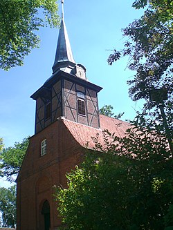
 The church of Bergstedt in 2011 | |
| Coordinates: 53°40′16″N 10°07′37″E / 53.671111°N 10.126944°E | |
| Country | Germany |
| State | Hamburg |
| City | Hamburg |
| Borough | Hamburg-Wandsbek |
| Area | |
| • Total | 7.1 km2 (2.7 sq mi) |
| Population (2023-12-31)[1] | |
| • Total | 10,855 |
| • Density | 1,500/km2 (4,000/sq mi) |
| Time zone | UTC+01:00 (CET) |
| • Summer (DST) | UTC+02:00 (CEST) |
| Dialling codes | 040 |
| Vehicle registration | HH |

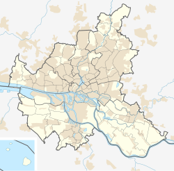
Bergstedt () is a quarter of Hamburg, Germany, in the borough of Wandsbek. It is located on the northeastern border of the borough and of the city. It is part of the area of Walddörfer (lit. forest villages). In 2023 10,855 lived in Bergstedt.
Geography
Bergstedt borders the quarters of Lemsahl-Mellingstedt, Wohldorf-Ohlstedt, Volksdorf, and Sasel. The streams and rivers of Furtbek, Lottbek, Rodenbek, and Saselbek flow through Bergstedt. There are two nature reserves, Hainesch/Iland and Rodenbeker Quellental.
Politics
These are the results of Bergstedt in the Hamburg state election:
| Election | Bergstedt | ||||||
|---|---|---|---|---|---|---|---|
| SPD | Greens | CDU | FDP | Left | AfD | Others | |
| 2020 | 40,7 % | 27,3 % | 11,8 % | 6,0 % | 5,4 % | 4,7 % | 4,1 % |
| 2015 | 48,0 % | 13,7 % | 15,3 % | 8,5 % | 5,8 % | 5,8 % | 2,9 % |
| 2011 | 49,9 % | 13,2 % | 20,6 % | 8,6 % | 3,9 % | – | 3,8 % |
| 2008 | 31,3 % | 12,6 % | 44,1 % | 5,9 % | 4,5 % | – | 1,6 % |
| 2004 | 26,1 % | 16,2 % | 49,2 % | 3,9 % | – | – | 4,7 % |
| 2001 | 34,0 % | 10,9 % | 30,0 % | 5,8 % | 0,3 % | – | 19,0 % |
| 1997 | 30,7 % | 17,2 % | 35,4 % | 4,0 % | 0,3 % | – | 12,4 % |
| 1993 | 32,1 % | 18,6 % | 28,5 % | 4,7 % | – | – | 16,1 % |
History
In 1248 Bergstedt, formerly a Saxonian Rundling, was first recorded under the name of Bericstede. It does not relate to a Berg (mountain), but to a founder named Beric. Also the part -stedt in the name refers to a Saxonian foundation, meaning safe settlement or safe residence.[2] The Church of Bergstedt (Bergstedter Kirche) was also first recorded in 1248, its oldest parts originating from 13th century. Therefore it is one of the oldest church buildings in Hamburg.
Nature reserves

In the southeast of Bergstadt lies the natural monument of Timmermoor, roughly 4 hectares in area, a bog pond surrounded by heathland and woods, which was formed in the last ice age about 20,000 years ago, probably as a result of the sinking of the soil layers over thawing dead ice.[3]
In the southwest of the quarter, between the Alster tributary of the Saselbek and its tributary, the Furtbek, lies the Hainesch/Iland Nature Reserve.
In the north lies the Rodenbeker Quellental Nature Reserve.
References
- ^ "Bevölkerung in Hamburg am 31.12.2023 nach Stadtteilen". Statistisches Amt für Hamburg und Schleswig-Holstein. May 2024.
- ^ Horst Beckershaus: Die Namen der Hamburger Stadtteile. Woher sie kommen und was sie bedeuten, Hamburg 2002, ISBN 3-434-52545-9, p. 19
- ^ "Freie und Hansestadt Hamburg, Behörde für Stadtentwicklung und Umwelt: Timmermoor". Archived from the original on 2016-03-27. Retrieved 2017-04-07.
External links
- Bergstedt, Hamburg.de


