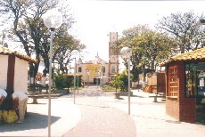
Biritiba-Mirim
Appearance
This article needs additional citations for verification. (October 2008) |
Biritiba Mirim | |
|---|---|
 Biritiba Mirim plaza | |
 Location of Biritiba Mirim | |
| Coordinates: 23°34′22″S 46°02′20″W / 23.57278°S 46.03889°W | |
| Country | |
| Region | Southeast |
| State | |
| Metropolitan Region | São Paulo |
| Government | |
| • Mayor | Walter Hideki Tajiri (PTB) |
| Area | |
• Total | 317.41 km2 (122.55 sq mi) |
| Population (2020 [1]) | |
• Total | 32,936 |
| • Density | 86.77/km2 (224.7/sq mi) |
| Time zone | UTC−3 (BRT) |
| HDI (2000) | 0,750 – medium |
| Website | Biritiba Mirim |
Biritiba Mirim is a Brazilian municipality of the state of São Paulo. It is part of the Metropolitan Region of São Paulo.[2] The population is 32,936 (2020 est.) in an area of 317.41 km².[3] Its limits are Guararema in the north, Salesópolis in the east, Bertioga to the south and Mogi das Cruzes in the west and northwest.
Media
In telecommunications, the city was served by Companhia de Telecomunicações do Estado de São Paulo until 1973, when it began to be served by Companhia Telefônica da Borda do Campo. In July 1998, this company was acquired by Telefónica, which adopted the Vivo brand in 2012.[4]
The company is currently an operator of cell phones, fixed lines, internet (fiber optics/4G) and television (satellite and cable).[4]
References
- ^ IBGE 2020
- ^ "Lei Complementar nº 1.139, de 16 de junho de 2011". Archived from the original on 2015-10-01. Retrieved 2015-09-30.
- ^ Instituto Brasileiro de Geografia e Estatística
- ^ a b "Our History - Telefônica RI". Telefônica. Retrieved 2024-05-26.
External links
- (in Portuguese) Biritiba Mirim Official Site


