Linnei
Appearance
23°45′33″N 120°37′06″E / 23.75911°N 120.618355°E
Linnei Township 林內鄉 | |
|---|---|
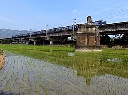
 Rail bridge crossing the Zhuoshui River in Linnei Township | |
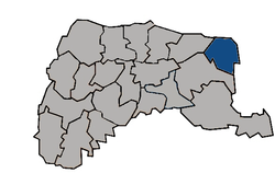
 Linnei Township in Yunlin County | |
| Location | Yunlin County, Taiwan |
| Area | |
| • Total | 38 km2 (15 sq mi) |
| Population (February 2023) | |
| • Total | 16,856 |
| • Density | 440/km2 (1,100/sq mi) |
Linnei Township (traditional Chinese: 林內鄉; simplified Chinese: 林内乡; pinyin: Línnèi Xiāng) is a rural township in Yunlin County, Taiwan. It is the second smallest township in Yunlin County after Baozhong Township.
History
During the Japanese era, Toroku Town (斗六街) covered modern-day Douliu and Linnei and was under Toroku District of Tainan Prefecture.
Geography
It has a population total of 16,856 and an area of 37.6035 km2.
Administrative divisions
Linnan, Linzhong, Linbei, Pingding, Linmao, Jiuqiong, Huben, Wutu, Wuma and Zhongxing Village.
Tourist attractions
- Baima Temple
- Farming and Irrigation Artifacts Museum
- Linnei Park
- Mount Xiao Huang
- Pingding Ruins
- Tian Shen Temple
- Wutu Power Plant
Transportation

The township is accessible by Linnei Station of Taiwan Railways.
References
External links
Wikimedia Commons has media related to Linnei Township, Yunlin County.

