Pakdasht County
Pakdasht County
Persian: شهرستان پاکدشت | |
|---|---|
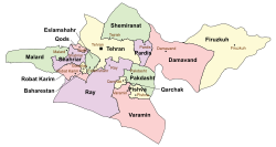
 Location of Pakdasht County in Tehran province (center right, green) | |
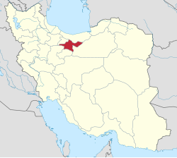
 Location of Tehran province in Iran | |
| Coordinates: 35°29′N 51°46′E / 35.483°N 51.767°E[1] | |
| Country | |
| Province | Tehran |
| Capital | Districts |
| Districts | Central, Sharifabad |
| Population (2016)[2] | |
• Total | 350,966 |
| Time zone | UTC+3:30 (IRST) |
| Pakdasht County can be found at GEOnet Names Server, at this link, by opening the Advanced Search box, entering "9206101" in the "Unique Feature Id" form, and clicking on "Search Database". | |
Pakdasht County (Persian: شهرستان پاکدشت) is in Tehran province, Iran. Its capital is the city of Pakdasht.[3] Pakdasht is a center of flower production in Iran. About 800,000 hectares of greenhouses for producing flowers exist in this area.[citation needed]
History
After the 2006 National Census, the village of Ferunabad was elevated to the status of a city.[4]
Demographics
Population
At the time of the 2006 census, the county's population was 240,841 in 61,234 households.[5] The following census in 2011 counted 291,397 people in 81,402 households.[6] The 2016 census measured the population of the county as 350,966 in 103,542 households.[2]
Administrative divisions
Pakdasht County's population history and administrative structure over three consecutive censuses are shown in the following table.
| Administrative Divisions | 2006[5] | 2011[6] | 2016[2] |
|---|---|---|---|
| Central District | 203,050 | 249,456 | 286,528 |
| Ferunabad RD | 17,065 | 5,723 | 6,136 |
| Filestan RD | 14,622 | 16,147 | 15,926 |
| Hesar-e Amir RD[a] | 45,082 | 6,659 | 6,465 |
| Ferunabad (city) | 14,437 | 21,682 | |
| Pakdasht (city) | 126,281 | 206,490 | 236,319 |
| Sharifabad District | 37,791 | 41,941 | 64,433 |
| Jamalabad RD | 12,718 | 13,426 | 29,684 |
| Karimabad RD[b] | 7,325 | 6,933 | 7,106 |
| Sharifabad RD | 8,878 | 9,250 | 9,362 |
| Sharifabad (city) | 8,870 | 12,332 | 18,281 |
| Total | 240,841 | 291,397 | 350,966 |
| RD = Rural District | |||
Climate
According to the information of the State Meteorological Organization of Iran, the long-term average annual rainfall of Pakdasht is around 153.2 mm[7]
See also
![]() Media related to Pakdasht County at Wikimedia Commons
Media related to Pakdasht County at Wikimedia Commons
Notes
- ^ Formerly Behnampazuki-ye Shomali Rural District[3]
- ^ Formerly Behnamsokhteh-e Shomali Rural District[3]
References
- ^ OpenStreetMap contributors (20 September 2024). "Pakdasht County" (Map). OpenStreetMap (in Persian). Retrieved 20 September 2024.
- ^ a b c Census of the Islamic Republic of Iran, 1395 (2016): Tehran Province. amar.org.ir (Report) (in Persian). The Statistical Center of Iran. Archived from the original (Excel) on 12 December 2021. Retrieved 19 December 2022.
- ^ a b c Habibi, Hassan (6 July 2014) [Approved 11 March 1375]. Creation and establishment of several rural districts and districts in Tehran province. rc.majlis.ir (Report) (in Persian). Ministry of the Interior, Political-Defense Commission of the Government Board. Notification 54560/T17820K. Archived from the original on 27 June 2014. Retrieved 26 December 2023 – via Islamic Parliament Research Center.
- ^ Rahimi, Mohammad Reza (13 August 2019). "Six new cities were added to the map of country divisions; with seven changes in the geography of several provinces of the country". dolat.ir (in Persian). Ministry of the Interior, Political and Defense Commission. Archived from the original on 3 August 2020. Retrieved 2 April 2023 – via Secretariat of the Government Information Council.
- ^ a b Census of the Islamic Republic of Iran, 1385 (2006): Tehran Province. amar.org.ir (Report) (in Persian). The Statistical Center of Iran. Archived from the original (Excel) on 20 September 2011. Retrieved 25 September 2022.
- ^ a b Census of the Islamic Republic of Iran, 1390 (2011): Tehran Province. irandataportal.syr.edu (Report) (in Persian). The Statistical Center of Iran. Archived from the original (Excel) on 20 January 2023. Retrieved 19 December 2022 – via Iran Data Portal, Syracuse University.
- ^ https://tehranmet.ir/uploads/tahghighat/140201.pdf [bare URL PDF]

