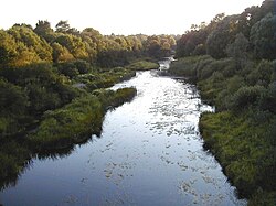
Bārta
This article includes a list of general references, but it lacks sufficient corresponding inline citations. (May 2022) |
| Bārta / Bartuva | |
|---|---|
 Bārta in Latvia | |
 | |
| Location | |
| Country | Lithuania and Latvia |
| Physical characteristics | |
| Source | |
| • location | Plungė district |
| Mouth | |
• location | Liepāja lake |
| Length | 103 km (64 mi) (56 km in Lithuania; 47 km in Latvia) |
| Basin size | 2,016 km2 (778 sq mi) (980 km2 in Lithuania; 1036 km2 in Latvia) |
| Discharge | |
| • average | 11.1 m3/s (390 cu ft/s) |
Bārta (in Latvian), also named Bartuva (in Lithuanian), is a river in western Lithuania and Latvia. It originates in the Plungė district, 3 km to north of Lake Plateliai. The Bārta flows in a northwesterly direction, passing through the Skuodas district and the city of Skuodas, before entering Latvia. The Bārta flows into Liepāja lake, which is connected with the Baltic Sea. In its upper courses the valley formed by the Bārta is deep and narrow, while in its lower courses it is much wider.
Bārta's main tributaries are the Eiškūnas, Erla, Luoba, Apšė, Vārtāja.
Major settlements along the river: Nīca (Latvia), Skuodas (Lithuania), Mosėdis (Lithuania), Bārta (Latvia).
The etymology of the name Bārta/Bartuva is unclear. Kazimieras Būga it derived from the Baltic tribe name Bartians. Another version is that it is archaic name which may be connected to Old Russian бара ('puddle'), Ukrainian: бар ('damp place between hills'), Illyrian *bar(b)- ('puddle').[1]
56°24′59″N 21°03′04″E / 56.41639°N 21.05111°E
References
[edit]- ^ Vanagas, Aleksandras (1981). Lietuvių hidronimų etimologinis žodynas (in Lithuanian). Vilnius: Mokslas. p. 59.
External links
[edit]- "Bartów". Geographical Dictionary of the Kingdom of Poland (in Polish). 1. Warszawa: Kasa im. Józefa Mianowskiego. 1880. p. 113.
