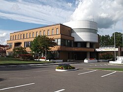
Rankoshi, Hokkaido
Appearance
(Redirected from Rankoshi, Hokkaidō)
Rankoshi
蘭越町 | |
|---|---|
Town | |
 Rankoshi Town Office | |
 Location of Rankoshi in Hokkaido (Shiribeshi Subprefecture) | |
| Coordinates: 42°49′N 140°32′E / 42.817°N 140.533°E | |
| Country | Japan |
| Region | Hokkaido |
| Prefecture | Hokkaido (Shiribeshi Subprefecture) |
| District | Isoya |
| Government | |
| • Mayor | Tomeo Miyauchi |
| Area | |
• Total | 449.68 km2 (173.62 sq mi) |
| Population (September 30, 2016) | |
• Total | 4,893 |
| • Density | 11/km2 (28/sq mi) |
| Time zone | UTC+09:00 (JST) |
| City hall address | 258-5 Rankoshicho, Rankoshi, Isoya-gun, Hokkaido 048-1392 |
| Climate | Dfb |
| Website | www |
| Symbols | |
| Flower | Magnolia kobus |
| Mascot | Love-chan (らぶちゃん) |
| Tree | Magnolia kobus |
Rankoshi (蘭越町, Rankoshi-chō) is a town located in Shiribeshi Subprefecture, Hokkaido, Japan.
As of September 2016, the town has an estimated population of 4,893, and a density of 11 persons per km2. The total area is 449.68 km2.
Geography
[edit]Shiribetsu River flows through Rankoshi to the Sea of Japan. The town is surrounded by Niseko Volcanic Group, which belongs to Niseko-Shakotan-Otaru Kaigan Quasi-National Park.
The name is derived from Ainu word "Ranko-usi", meaning "Place with many Katsura trees".[1]
- Mountains: Mount Raiden, Mount Mekunnai, Mount Chisenupuri, Mount Nitonupuri
Neighboring towns
[edit]- Iburi Subprefecture
- Shiribeshi Subprefecture
Climate
[edit]| Climate data for Rankoshi (1991−2020 normals, extremes 1977−present) | |||||||||||||
|---|---|---|---|---|---|---|---|---|---|---|---|---|---|
| Month | Jan | Feb | Mar | Apr | May | Jun | Jul | Aug | Sep | Oct | Nov | Dec | Year |
| Record high °C (°F) | 8.7 (47.7) |
9.7 (49.5) |
15.0 (59.0) |
25.2 (77.4) |
33.1 (91.6) |
32.7 (90.9) |
33.7 (92.7) |
35.4 (95.7) |
32.1 (89.8) |
25.9 (78.6) |
20.7 (69.3) |
13.6 (56.5) |
35.4 (95.7) |
| Mean daily maximum °C (°F) | −0.8 (30.6) |
0.0 (32.0) |
3.9 (39.0) |
10.6 (51.1) |
17.3 (63.1) |
21.3 (70.3) |
24.7 (76.5) |
25.9 (78.6) |
22.4 (72.3) |
15.8 (60.4) |
7.9 (46.2) |
1.2 (34.2) |
12.5 (54.5) |
| Daily mean °C (°F) | −4.2 (24.4) |
−3.7 (25.3) |
−0.2 (31.6) |
5.4 (41.7) |
11.4 (52.5) |
15.9 (60.6) |
19.9 (67.8) |
20.9 (69.6) |
16.8 (62.2) |
10.1 (50.2) |
3.6 (38.5) |
−2.1 (28.2) |
7.8 (46.1) |
| Mean daily minimum °C (°F) | −8.2 (17.2) |
−8.1 (17.4) |
−4.8 (23.4) |
0.0 (32.0) |
5.7 (42.3) |
11.4 (52.5) |
16.1 (61.0) |
16.8 (62.2) |
11.7 (53.1) |
4.8 (40.6) |
−0.5 (31.1) |
−5.6 (21.9) |
3.3 (37.9) |
| Record low °C (°F) | −24.7 (−12.5) |
−24.1 (−11.4) |
−19.2 (−2.6) |
−10.5 (13.1) |
−2.6 (27.3) |
2.0 (35.6) |
5.5 (41.9) |
7.5 (45.5) |
1.3 (34.3) |
−3.9 (25.0) |
−11.9 (10.6) |
−20.3 (−4.5) |
−24.7 (−12.5) |
| Average precipitation mm (inches) | 104.2 (4.10) |
79.6 (3.13) |
59.2 (2.33) |
61.0 (2.40) |
74.1 (2.92) |
64.1 (2.52) |
104.2 (4.10) |
142.2 (5.60) |
142.9 (5.63) |
120.9 (4.76) |
137.2 (5.40) |
125.9 (4.96) |
1,220.4 (48.05) |
| Average snowfall cm (inches) | 213 (84) |
169 (67) |
107 (42) |
13 (5.1) |
0 (0) |
0 (0) |
0 (0) |
0 (0) |
0 (0) |
0 (0) |
53 (21) |
194 (76) |
746 (294) |
| Average precipitation days (≥ 1.0 mm) | 21.2 | 17.5 | 13.8 | 10.3 | 9.3 | 8.3 | 8.8 | 9.7 | 11.7 | 14.3 | 18.3 | 21.8 | 165 |
| Average snowy days (≥ 3 cm) | 21.0 | 18.1 | 13.7 | 2.0 | 0 | 0 | 0 | 0 | 0 | 0 | 5.8 | 19.4 | 80 |
| Mean monthly sunshine hours | 33.3 | 48.2 | 99.5 | 164.9 | 196.4 | 160.6 | 131.4 | 142.9 | 148.7 | 122.7 | 63.2 | 26.4 | 1,338 |
| Source: Japan Meteorological Agency[2][3] | |||||||||||||
History
[edit]- 1909: Minamishiribeshi became a Second Class Village.[4]
- 1940: Minamishiribeshi became a First Class Village.
- 1954: Minamishiribeshi Village became Rankoshi Town.
- 1955: A part of Suttsu Town was merged into Rankoshi Town.
Education
[edit]- High school
- Hokkaido Rankoshi High School[5]
- Junior high school
- Rankoshi Junior High School
- Elementary schools
- Kombu Elementary School
- Rankoshi Elementary School
Transportation
[edit]Sister city
[edit] Saalfelden, Salzburg, Austria (since 1967)[6]
References
[edit]- ^ Outline of Rankoshi
- ^ 観測史上1~10位の値(年間を通じての値). JMA. Retrieved March 19, 2022.
- ^ 気象庁 / 平年値(年・月ごとの値). JMA. Retrieved March 19, 2022.
- ^ History of Rankoshi
- ^ Hokkaido Rankoshi High School
- ^ Sister city
External links
[edit] Media related to Rankoshi, Hokkaidō at Wikimedia Commons
- Official Website (in Japanese)


