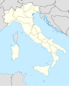
Putifigari
Putifigari é uma comuna italiana da região da Sardenha, província de Sassari, com cerca de 700 habitantes. Estende-se por uma área de 53 km², tendo uma densidade populacional de 13 hab/km². Faz fronteira com Alghero, Ittiri, Uri, Villanova Monteleone.[1][2][3]
| ||||
|---|---|---|---|---|
| Comuna | ||||
 | ||||
| Localização | ||||
| Localização de Putifigari na Itália | ||||
| Coordenadas | 40° 34′ N, 8° 28′ L | |||
| País | Itália | |||
| Região | ||||
| Província | Sassari | |||
| Características geográficas | ||||
| Área total | 53 km² | |||
| População total | 700 hab. | |||
| Densidade | 13,2 hab./km² | |||
| Altitude | 267 m | |||
| Outros dados | ||||
| Comunas limítrofes | Alghero, Ittiri, Uri, Villanova Monteleone | |||
| Código ISTAT | 090060 | |||
| Código cadastral | ||||
| Código postal | ||||
| Prefixo telefônico | 079 | |||
| Padroeiro | ||||
| Sítio | www | |||
History
editarThe area was inhabited since the Neolithic period, due to the presence in the territory some domus de janas with a necropolis.
During the Middle Ages it belonged to the giudicato of Torres and was part of the curatoria of Florinas. At the fall of the giudicato (1259) it came under the rule of the Genoese Doria family, and later, around 1350, it was subject to the Aragonese conquest. In 1364 the town was given as a fief by King Peter IV the Ceremonious of Aragon to Pietrino Boyl, who was created baron of Putifigari. From this family it passed to the Sassarese Sussarello family, which sold the fief to Archbishop Antonio Canopolo[4]. The latter gave it back to the Sussarello in February 1610. In the 18th century Putifigari was elevated to a marquisate and the Boyls, having returned to possession of the fief, to marquisate. The town was redeemed to the last feudal lord, Francesco Maria Pilo Boyl, in 1839 with the suppression of the feudal system.
Demografia
editar| Variação demográfica do município entre 1861 e 2011[3] |
 |
| Fonte: Istituto Nazionale di Statistica (ISTAT) - Elaboração gráfica da Wikipedia |
Referências
- ↑ «Statistiche demografiche ISTAT» (em italiano). Dato istat
- ↑ «Popolazione residente al 31 dicembre 2010» (em italiano). Dato istat
- ↑ a b «Istituto Nazionale di Statistica» 🔗 (em italiano). Statistiche I.Stat
- ↑ Naso, Irma (28 de fevereiro de 2018). «Il collegio dei medici dì Novara negli ultimi anni del Quattrocento. Contributo allo studio dei gruppi professionali al termine del medioevo». Studi di storia medioevale e di diplomatica - Nuova Serie (4). ISSN 2611-318X. doi:10.54103/2611-318x/9667. Consultado em 5 de fevereiro de 2024
