Algarve
Algarve
Distrito de Faro | |
|---|---|
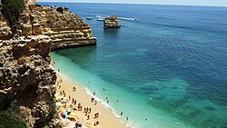
 Algarve's typical coast (Marinha Beach, near Lagoa) | |
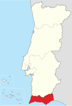
 Location of the Algarve Region in relation to the national borders | |
| Country | Portugal |
| Region | Algarve |
| Capital | Faro |
| Area | |
| • Total | 4,996.80 km2 (1,929.28 sq mi) |
| Population (2021) | |
| • Total | 467,495 (5th) |
| Time zone | UTC+0 (WET) |
| • Summer (DST) | UTC+1 (WEST) |
| ISO 3166 code | PT-08 |
| HDI (2018) | 0.847[1] very high · 4th |
| GDP (PPP) | 2019 estimate |
| – Total | €9,274 billion[2] |
| – Per capita | €24,900[3] |
| GDP (nominal) | 2019 estimate |
| Website | www |
| Statistics from INE (2005); geographic detail from Instituto Geográfico Português (2010) | |
The Algarve (from Arabic: الغرب al-Gharb "the West") is the southernmost region of continental Portugal. The capital of the Algarve is the city of Faro. There is an international airport and a public university (University of Algarve).
The present region of Algarve coincides with the old province of the same name and with the Faro district. The main economic activity in the region is tourism because its beaches and its historical buildings.
History
[change | change source]The name Algarve comes from Gharb Al-Andalus (Arabic: غرب الأندلس, gharb al-ʼandalus; "The West of Al-Andalus"), or just Al-Gharb (Arabic: الغرب, al-gharb; "The West"), the name given by the Muslims of Iberia to the region to the west of Andalusia.[4]
Geography
[change | change source]Algarve has an area of 744.57 square kilometres (287.48 square miles).[5] It borders with the Alentejo region (Alentejo Litoral and Baixo Alentejo subregions) to the north, the Atlantic Ocean to the west and south, and the Guadiana river, and Andalusia (Spain), to the east.
The Algarve region is divided in two zones, each with eight municipalities:
- Barlavento, the western zone, with Portimão as main city; and
- Sotavento, the eastern zone, with Faro as main city.
The main mountain ranges are Serra de Monchique, la Serra de Espinhaço de Cão and Serra do Caldeirão. The highest point in the region is the Fóia mountain, 902 metres (2,959 feet) high,[6] in the Serra de Monchique mountain range.
The westernmost point of the region, and of continental Europa, is Cape St. Vincent (Portuguese: Cabo de São Vicente),[7] in the municipality of Vila do Bispo.
Administrative division
[change | change source]Algarve is formed by 16 municipalities (or concelhos) and 67 freguesias.

| Map | Municipality | Population (2011) |
Area (km²) |
Population density |
Freguesias |
|---|---|---|---|---|---|
| Barlavento zone | |||||
| 1 | Vila do Bispo | 5,258 | 179.06 | 29.4 | 4 |
| 2 | Aljezur | 5,884 | 323.50 | 18.2 | 4 |
| 3 | Monchique | 6,045 | 395.30 | 15.3 | 3 |
| 4 | Lagos | 31,049 | 212.99 | 145.8 | 4 |
| 5 | Portimão | 55,614 | 182.06 | 305.5 | 3 |
| 6 | Lagoa | 22,975 | 88.25 | 260.3 | 4 |
| 7 | Silves | 37,126 | 680.06 | 54.6 | 6 |
| 8 | Albufeira | 40,828 | 140.66 | 290.3 | 4 |
| Sotavento zone | |||||
| 9 | Loulé | 70,622 | 763.67 | 92.5 | 9 |
| 10 | Faro | 64,560 | 202.57 | 318.7 | 4 |
| 11 | São Brás de Alportel | 10,622 | 153.37 | 69.3 | 1 |
| 12 | Olhão | 45,396 | 130.86 | 346.9 | 4 |
| 13 | Tavira | 26,167 | 606.97 | 43.1 | 6 |
| 14 | Alcoutim | 2,917 | 575.36 | 5.1 | 4 |
| 15 | Castro Marim | 6,747 | 300.84 | 22.4 | 4 |
| 16 | Vila Real de Santo António | 19,156 | 61.25 | 312.8 | 3 |
Among the 16 municipalities, Loulé is the largest of the region, with an área of 763.67 square kilometres (294.85 square miles); this municipality and Silves border both the Alentejo region and the Atlantic Ocean. Vila Real de Santo António is the smallest municipality with an área of 61.25 square kilometres (23.65 square miles).
Only three municipalities do not border the ocean: Monchique, São Brás de Alportel and Alcoutim.
Economy
[change | change source]
Farming products of the region include fig, almond, orange, carob bean, strawberry tree and cork oak. Horticulture is also important. Fishing and aquaculture are important activities in the coastal area of Algarve.
The wines of the region are well-known. There are four wines in the region which have Protected Designation of Origin (Denominação de Origem Controlada – DOC): Lagoa DOC, Lagos DOC, Portimão DOC and Tavira DOC.
Food processing, cement and construction, are the main industries.
Tourism related activities are extensive and make the bulk of Algarve's economy during summer time.
Gallery
[change | change source]-
The city of Tavira
-
The historic centre of Lagos
-
Portimão at night
-
Partial view of Carvoeiro
-
A beach in Albufeira
-
Municipal market of Loulé
References
[change | change source]- ↑ "Sub-national HDI – Area Database – Global Data Lab". hdi.globaldatalab.org. Retrieved 12 June 2021.
- ↑ "EU Regions". Eurostat.
- ↑ "Internal Market, Industry, Entrepreneurship and SMEs – Algarve Region of Portugal". European Commission. Retrieved 19 March 2020.
- ↑ A. Huici Miranda. "G̲h̲arb al-Andalus" (in French). Encyclopédie de l’Islam. Retrieved 7 August 2016.
- ↑ "Portal de Estatísticas Oficiais". Instituto Nacional de Estatística - Statistics Portugal. 16 June 2014. Retrieved 6 August 2016.
- ↑ "Mont Fóia" (in French). Guide michelin. Archived from the original on 29 January 2022. Retrieved 7 August 2016.
- ↑ "Cabo de São Vicente" (in French). Internaute.com. Retrieved 7 August 2016.
Other websites
[change | change source] Algarve travel guide from Wikivoyage
- Associação de Turismo do Algarve


