Khác biệt giữa bản sửa đổi của “Machov”
Giao diện
Nội dung được xóa Nội dung được thêm vào
n r2.7.3) (Bot: Dời roa-rup:Machov |
Đã cứu 1 nguồn và đánh dấu 0 nguồn là hỏng.) #IABot (v2.0.9.5 |
||
| (Không hiển thị 7 phiên bản của 7 người dùng ở giữa) | |||
| Dòng 7: | Dòng 7: | ||
|motto = |
|motto = |
||
<!-- images and maps -----------> |
<!-- images and maps -----------> |
||
|image_skyline = |
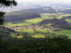
|image_skyline = Machov - panorama CS.jpg |
||
|imagesize = |
|imagesize = |
||
|image_caption = |
|image_caption = |
||
|image_flag = |
|image_flag = Machov vlajka.jpg |
||
|flag_size = |
|flag_size = |
||
|image_seal = |
|image_seal = |
||
|seal_size = |
|seal_size = |
||
|image_shield = |
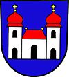
|image_shield = Machov znak.jpg |
||
|shield_size = |
|shield_size = |
||
|image_map = |
|image_map = |
||
| Dòng 25: | Dòng 25: | ||
|subdivision_name = {{flag|Cộng hòa Séc}} |
|subdivision_name = {{flag|Cộng hòa Séc}} |
||
|subdivision_type1 = [[Vùng của Cộng hòa Séc|Vùng]] |
|subdivision_type1 = [[Vùng của Cộng hòa Séc|Vùng]] |
||
|subdivision_name1 = [[ |
|subdivision_name1 = [[Hradec Králové (vùng)|Královéhradecký]] |
||
|subdivision_type2 = [[Huyện của Cộng hòa Séc|Huyện]] |
|subdivision_type2 = [[Huyện của Cộng hòa Séc|Huyện]] |
||
|subdivision_name2 =[[Náchod (huyện)|Náchod]] |
|subdivision_name2 =[[Náchod (huyện)|Náchod]] |
||
| Dòng 41: | Dòng 41: | ||
|unit_pref = <!--Enter: Imperial, if Imperial (metric) is desired--> |
|unit_pref = <!--Enter: Imperial, if Imperial (metric) is desired--> |
||
|area_footnotes = |
|area_footnotes = |
||
|area_total_km2 =<!-- ALL fields dealing with a measurements are subject to automatic unit conversion--> |
|area_total_km2 = 19.39 <!-- ALL fields dealing with a measurements are subject to automatic unit conversion--> |
||
|area_land_km2 = <!--See table @ Template:Infobox Settlement for details on automatic unit conversion--> |
|area_land_km2 = <!--See table @ Template:Infobox Settlement for details on automatic unit conversion--> |
||
|area_metro_km2 = |
|area_metro_km2 = |
||
<!-- Population -----------------------> |
<!-- Population -----------------------> |
||
|population_as_of = |
|population_as_of = 1.1.2012 |
||
|population_footnotes = |
|population_footnotes = |
||
|population_note = |
|population_note = |
||
|population_total = |
|population_total = 1108 |
||
|population_density_km2 = |
|population_density_km2 = auto |
||
<!-- General information ---------------> |
<!-- General information ---------------> |
||
|timezone = [[Giờ Trung Âu|CET]] |
|timezone = [[Giờ chuẩn Trung Âu|CET]] |
||
|utc_offset =+1 |
|utc_offset =+1 |
||
|timezone_DST = [[Giờ Mùa hè Trung Âu|CEST]] |
|timezone_DST = [[Giờ Mùa hè Trung Âu|CEST]] |
||
| Dòng 58: | Dòng 58: | ||
|longd=|longm=|longs=|longEW=E |
|longd=|longm=|longs=|longEW=E |
||
|elevation_footnotes = <!--for references: use <ref> </ref> tags--> |
|elevation_footnotes = <!--for references: use <ref> </ref> tags--> |
||
|elevation_m = |
|elevation_m = 450 |
||
|elevation_ft = |
|elevation_ft = |
||
<!-- Area/postal codes & others --------> |
<!-- Area/postal codes & others --------> |
||
| Dòng 70: | Dòng 70: | ||
|website = |
|website = |
||
|footnotes = |
|footnotes = |
||
}} |
}} |
||
'''Machov''' là một [[Chợ huyện của Cộng hòa Séc|chợ huyện]] thuộc huyện [[Náchod (huyện)|Náchod]], vùng [[ |
'''Machov''' là một [[Chợ huyện của Cộng hòa Séc|chợ huyện]] thuộc huyện [[Náchod (huyện)|Náchod]], vùng [[Hradec Králové (vùng)|Královéhradecký]], [[Cộng hòa Séc]].<ref>{{chú thích web|url=http://www.czso.cz/csu/klasifik.nsf/i/ii_struktura_uzemi_ceske_republiky/|title=Struktura území ČR od 1.1.2008 do 1.1.2012 - xls|accessdate=ngày 8 tháng 8 năm 2012|archive-date=2012-06-28|archive-url=https://web.archive.org/web/20120628044327/http://www.czso.cz/csu/klasifik.nsf/i/ii_struktura_uzemi_ceske_republiky/|url-status=dead}}</ref> |
||
== Tham khảo == |
== Tham khảo == |
||
| Dòng 78: | Dòng 78: | ||
{{Sơ khai địa lý Cộng hòa Séc}} |
{{Sơ khai địa lý Cộng hòa Séc}} |
||
[[Thể loại: |
[[Thể loại:Khu dân cư ở huyện Náchod]] |
||
[[Thể loại:Chợ huyện của Cộng hòa Séc]] |
[[Thể loại:Chợ huyện của Cộng hòa Séc]] |
||
[[cs:Machov]] |
|||
[[de:Machov]] |
|||
[[en:Machov]] |
|||
[[it:Machov]] |
|||
[[nl:Machov]] |
|||
[[pl:Machov]] |
|||
[[sk:Machov]] |
|||
Bản mới nhất lúc 16:12, ngày 3 tháng 9 năm 2024
| Machov | |
|---|---|
| — Chợ huyện — | |
 | |
| Quốc gia | |
| Vùng | Královéhradecký |
| Huyện | Náchod |
| Diện tích | |
| • Tổng cộng | 19,39 km2 (749 mi2) |
| Độ cao | 450 m (1,480 ft) |
| Dân số (1.1.2012) | |
| • Tổng cộng | 1.108 |
| • Mật độ | 0,57/km2 (1,5/mi2) |
| • Mùa hè (DST) | CEST (UTC+2) |
| NUTS 5 | 549 63, 549 31 |
Machov là một chợ huyện thuộc huyện Náchod, vùng Královéhradecký, Cộng hòa Séc.[1]
Tham khảo
[sửa | sửa mã nguồn]- ^ “Struktura území ČR od 1.1.2008 do 1.1.2012 - xls”. Bản gốc lưu trữ ngày 28 tháng 6 năm 2012. Truy cập ngày 8 tháng 8 năm 2012.


