Geomorphology 201 (2013) 512–519
Contents lists available at ScienceDirect
Geomorphology
journal homepage: www.elsevier.com/locate/geomorph
Discussion of ‘Field evidence and hydraulic modeling of a large Holocene
jökulhlaup at Jökulsá á Fjöllum channel, Iceland’ by Douglas Howard,
Sheryl Luzzadder-Beach and Timothy Beach, 2012
Jonathan L. Carrivick a,⁎, Fiona S. Tweed b, Paul Carling c, Petteri Alho d, Philip M. Marren e, Kate Staines a,
Andrew J. Russell f, E. Lucy Rushmer g, Robert Duller h
a
School of Geography, University of Leeds, Leeds, West Yorkshire, LS2 9JT, UK
Geography and Environment, Staffordshire University, College Road, Stoke-on-Trent, ST4 2DE, UK
c
Geography and Environment, Shackleton Building 44, University of Southampton, University Road, Southampton, SO17 1BJ, UK
d
Department of Geography and Geology, University of Turku, Turku FI-20014, Finland
e
Department of Resource Management and Geography, The University of Melbourne, Parkville 3010, Australia
f
School of Geography, Politics and Sociology, Daysh Building, University of Newcastle, Newcastle upon Tyne, NEI 7RU, UK
g
Jacobs, 1 City Walk, Leeds, West Yorkshire, LS11 9DX, UK
h
Department of Earth & Ocean Sciences, School of Environmental Sciences, University of Liverpool, 4 Brownlow Street, Liverpool, L69 3GP, UK
b
a r t i c l e
i n f o
Article history:
Received 14 March 2012
Received in revised form 1 June 2012
Accepted 23 October 2012
Available online 30 October 2012
Keywords:
Jökulsá á Fjöllum
Iceland
Outburst flood
Landscape
Hydraulics
a b s t r a c t
This paper discusses Howard et al. (2012) who reconstruct the peak discharge of a glacial outburst flood, or
‘jökulhlaup’, for part of the Jökulsá á Fjöllum in north-central Iceland. They propose that this flood was the
largest on Earth. We consider that the magnitude of the jökulhlaup proposed by Howard et al. (2012) warrants
much more robust field evidence and demands more carefully parameterised hydraulic modelling. For these
reasons we firstly (i) present their study in the context of previous research (ii) highlight issues with attributing landforms and sediments to jökulhlaups, and (iii) consider uncertainty regarding the timing and magnitude of jökulhlaups along the Jökulsá á Fjöllum. We argue herein that whilst a range of landforms and
sediments that are attributable to jökulhlaups can be observed along the Jökulsá á Fjöllum, these are not necessarily diagnostic of jökulhlaups. Secondly, we critically discuss (iv) the major underlying assumptions of
their study, and (v) their calculations and subsequent interpretations. These assessments lead us to consider
that the proposal by Howard et al. (2012) of the largest flood on Earth is highly unrealistic, especially when
due consideration is given to a possible source area and a trigger mechanism.
© 2012 Elsevier B.V. All rights reserved.
1. Introduction
Howard et al. (2012) suggested that a glacial outburst flood or
‘jökulhlaup’ that routed along the Jökulsá á Fjöllum in northern Iceland during the early Holocene was the largest flood to have occurred
on Earth. They present field data, most importantly large boulders,
that they attribute to deposition by this flood and they use the elevation of these boulders to drive a hydraulic model that they suggest
reasonably represents the characteristics of this flood. However, we
feel that the field data as presented in their paper is both ambiguous
and insufficient. We therefore briefly review the field evidence for,
and research into, Jökulsá a Fjöllum jökulhlaups. Given the emphasis
placed on the exceptional magnitude of the flood and on the applicability of the work for studies on Mars, we also feel that it is very important
to question several assumptions that Howard et al. (2012) relied upon
for their calculations. This paper therefore proceeds to discuss these
⁎ Corresponding author. Tel.: +44 113 343 3324; fax: +44 113 343 3308.
E-mail address: j.l.carrivick@leeds.ac.uk (J.L. Carrivick).
0169-555X/$ – see front matter © 2012 Elsevier B.V. All rights reserved.
http://dx.doi.org/10.1016/j.geomorph.2012.10.024
assumptions, namely that: isolated large ‘erratic’ boulders are the product of jökulhlaup deposition, that the position and location of the boulders are sufficient to parameterise a step-backwater hydraulic model,
that a hill named ‘Ferjufjall’ must have been overtopped, that Manning's
n can be treated as a fixed quantity, that modelling a single reach of the
Jökulsá á Fjöllum can generate meaningful results, and finally that the
volume of water implied by such a large peak discharge could have
been sourced from northern Vatnajökull.
2. Discussion of research on Jökulsá á Fjöllum jökulhlaups
Attributing landforms and sediments to jökulhlaups (Table 1), particularly those jökulhlaups that occurred millennia ago, is far from
straight forward and has occupied many major research efforts focused
along the Jökulsá á Fjöllum (Table 2). In light of the claim by Howard et
al. (2012) of new and extraordinary evidence, the most important of
which is ‘large boulders’, we will herein firstly critically review the landscape upon which evidence of Holocene Jökulsá á Fjöllum jökulhlaups is
superimposed. We will then highlight the production and redistribution
�513
J.L. Carrivick et al. / Geomorphology 201 (2013) 512–519
Table 1
Summary of previous research identifying landforms and sediments along the course of Jökulsá á Fjöllum interpreted to be the product of jökulhlaups.
Author/publication year Landforms and sediments presented as evidence of Jökulsá á Fjöllum jökulhlaups
Erosional
Alho et al. (2005)
Knudsen and
Russell (2002)
Waitt (1998, 2002)
Giant gravel bars
Giant expansion bars
Extensive surfaces of well-rounded heterolithic gravel
Wash limits: erratic imbricated boulders
Large-scale sandy trough cross-bedded units capped by a boulder-rich unit,
interpreted as the product of a hyperconcentrated flow
Anastomosing water fluted and half pot-holed stripped basalt surfaces • Huge boulders
• Long gravel bars
Small-scale scabland, dry cataracts
• Giant current dunes
Anastomosing distributary cols through moderate relief landscape
• Graded gravel beds in channel
• Sand–silt backflood facies
• Occasional megaripples
Tear drop-shaped islands up to 5 km long
• Depositional tails
Cataracts, scabland
• Boulder fields
Broad lemniscate forms
• Wash limits: ‘debris lines’
• High water line overtopping large obstacles
• Shorelines
Ásbyrgi cataract
• Gravel-buried crater rows
Scabland
• Large gravel bars
Eroded crater rows
Grooving and striations on smoothed lava surfaces beyond the
N/A
glaciation limit
• Streamlined hills
• Scoured and plucked lava
• Large potholes
• Longitudinal grooves
N/A
•
•
•
Malin and Eppler
(1981)
•
•
•
Tómasson (1973)
•
•
•
•
Sæmundsson (1973)
Depositional
•
•
•
•
•
of large boulders in the landscape and then we will discuss the derivation and use of criteria to distinguish the genesis of jökulhlaup landforms amongst several key land surface processes.
Geological research along the Jökulsá á Fjöllum in Iceland was initiated to consider hydroelectric development (Thórarinsson, 1950,
1959; Helgason, 1987). Investigation of the Dettifoss canyon and of
Table 2
Summary of previous research suggesting timing and magnitude of jökulhlaups along the Jökulsá á Fjöllum.
Author/
publication
year
Identified floods
(years ago)
Estimated
peak discharge
(m3 s−1)
Proposed source/generation
mechanism
Acquired data/
Interpretation method
Techniques
Kirkbride et al.
(2006)
Alho et al.
(2005)
4100
3500 − 2900
N/A
>7 × 10⁵
Kverkfjöll Grímsvötn
0.9 × 10⁶
Barðabunga caldera
Field visit and laboratory
analysis
Step-backwater modelling
Waitt (2002)
1 × 2500 − 2000
1 × 9000 − 8000
16 × 8000 − 4000
2000
9000 − 8000
2500
0.7 × 10⁶
N/A
Kverkfjöll caldera
14C AMS dates from Betula
macrofossils within peat
PSIs: imbricated boulders and
washed bedrock (i.e. bedrock
with exotic well-rounded clasts)
Stratigraphy and tephra (H5)
1 × 10⁶
N/A
0.4 − 0.5 × 10⁶
1973; Kverkfjöll caldera or
Grimsvötn by subglacial melting,
but most likely ice-dammed
lake south of Kverkfjöll
2002; the Barðabunga caldera
N/A
N/A
Waitt (1998)
Tómasson
(1973, 2002)
Sæmundsson
(1973)
Earliest post-glacial
Less than 2900
Thórarinsson
(1959)
1490, 1655;
Spring/early winter 1684;
early November 1711/1712;
early winter 1716;
September/October 1717;
early September 1729; August
1655, 1684, 1711, 1712, 1776,
1717, 1729
Thórarinsson
(1950)
Helgason (1987)
Catastrophic 7100
4600
3000
2000
Hstoric
Perhaps 10 floods
within a ‘flood
period’ of
20–40 years
Minor
Approx. 2 per
century
Subglacial volcanic bursts in
the Kverkfjöll area and/or
Dyngjujökull
Not likely to be Dyngjujökull caldera/volcanogen
>15,000
1–1.5 km3
400,000
Ice-dammed lake
Tephra (H5)
Tephra (H3)
Field visit, 1986 and 2000
Geomorphological mapping
Step-backwater modelling
N/A
Aerial photograph
interpretation and field visits
Manning equation,
flood-filled canyon and measurement of present-day
topography
Field visit Geomorphological
mapping
Lava striations location relative
to moraines of maximum glacial
extent
Historical witness accounts from N/A
Axarfjordur and Keldhuverfi
Historical witness accounts from Field visit, 1946 to Kverkfjöll
Axarfjordur and Keldhuverfi
N/A
N/A
‘Volcanism’
10,000
Volcanic
N/A
N/A
1500
Rapid spring thaw or other
‘special circumstances’
N/A
N/A
�514
J.L. Carrivick et al. / Geomorphology 201 (2013) 512–519
a dry canyon system at Ásbyrgi provoked controversy because the
Jökulsá á Fjöllum is far too small in terms of its present and historic
flood discharge to have formed such canyons (Tómasson, 1973;
Malin and Eppler, 1981). Further analysis of Dettifoss and Ásbyrgi
canyons showed that they were products of very large jökulhlaups
(Thórarinsson, 1950; Sæmundsson, 1973; Tómasson, 1973; Waitt,
1998, 2002). The scale of these canyons prompted comparisons of
the Jökulsá á Fjöllum with (i) the Columbia plateau or Missoula floods
(Tómasson, 1973; Waitt, 1998, 2002), (ii) with other terrestrial megafloods (Baker, 2002), and (iii) with outburst floods on Mars (Malin and
Eppler, 1981; Baker, 2002; Chapman et al., 2003; Hovius et al., 2008)
and brought awareness to the geological importance and deglacial association of jökulhlaups (c.f. Carrivick, 2011). Howard et al. (2012) were
apparently motivated in their hydraulic modelling efforts by this analogy
of the north-central Iceland landscape with that on Mars.
Subsequent research identified other landforms and sediments
along the entire length of the Jökulsá á Fjöllum and attributed them
to jökulhlaups. These landforms include dry waterfalls or ‘cataracts’,
plucked-bedrock ‘scablands’ and bedrock flutings, and potholes
(Table 1). Depositional landforms of the Jökulsá á Fjöllum jökulhlaups
include boulders and gravel bars (Table 1). Most recent research has
used the geomorphological and sedimentological evidence to inform
hydraulic models, thereby enabling quantification of the inundation,
peak discharge, behaviour and likely source of the Jökulsá á Fjöllum
jökulhlaups (e.g. Alho et al., 2005, 2007; Carrivick, 2006, 2007a,b,
2009; Alho and Aaltonen, 2008).
Geomorphological evidence of Jökulsá á Fjöllum jökulhlaups is neither obvious nor coherent. This fact has been emphasised in the objective study to discriminate land cover characteristics in north-central
Iceland by Alho (2003) and by a more localised but intensive mapping
study across part of the southern (ice-proximal) reaches of the Jökulsá
á Fjöllum: in Kverkfjallarani and Kverkfjöll, by Carrivick and Twigg
(2005). Malin and Eppler (1981) were the first to draw caution to
interpretations of the geomorphology of the Jökulsá á Fjöllum. They
suggested that it could be difficult to distinguish between glacial and
jökulhlaup debris at a single point as glacial deposits can be subrounded and jökulhlaup deposits can be subangular. Malin and Eppler
(1981) pointed out that in ‘unconfined’ reaches, which can be up to
5–6 km wide (Tómasson, 1973), estimated that palaeo flow depths
were reduced to a few metres, and therefore that flood effects were
hard to distinguish.
Controversy also surrounds the limited sedimentary interpretations that have been made regarding the timing of jökulhlaups
along the Jökulsá á Fjöllum. Waitt (1998) claimed that previously
interpreted flood deposits in the lower canyon reaches of the Jökulsá
á Fjöllum were of aeolian origin and even that some stratigraphy was
man-made. Many jökulhlaups have been suggested to have occurred
in the Jökulsá á Fjöllum system between 8000 and 3000 BP (Table 2). Use
of tephrochronological methods has been restricted to the canyon localities within the distal reaches of the Jökulsá á Fjöllum (e.g., Kirkbride
et al., 2006). Differing routeways of multiple jökulhlaups have led to differential preservation of jökulhlaup landforms and sedimentary deposits.
Therefore it would be easy for single-site, or reach-based, analyses to be
extrapolated erroneously. In our opinion, this is one of the causes for the
ambiguity concerning the timing and magnitude of Jökulsá á Fjöllum
jökulhlaups (Table 2).
3. Holocene landscape evolution in north-central Iceland
The last glaciation in Iceland probably began 110,000 years ago
and ended about 11,000 years ago (Ingólfsson, 1994; Guðmundsson,
1997; Geirsdóttir et al., 2009). The modelling study of Hubbard et al.
(2006) and geological evidence (Norðdahl, 1990; Geirsdóttir and
Eiriksson, 1994) suggests that whilst at its maximum extent the last
Iceland Ice Sheet reached beyond the present northern coast of Iceland.
The Iceland Ice Sheet was dynamic, responsive, and influenced by oceanic
as well as climatic forcing (Hubbard et al., 2006; Geirsdóttir et al., 2009);
thereby providing a clear ability to produce (boulder-rich) glacigenic
landforms and deposits. Volcanism in north-central Iceland was about
20–30 times greater at this time of deglaciation than at present because
of a pressure release of pooled magma through differential tectonic
movements from ice unloading (e.g., Slater et al., 1998; Maclennan
et al., 2002). Consequently, subglacial and subaerial volcanic products –
including basalt ridge edifices and basalt entablature (both of which
can collapse to large piles of boulders) – were emplaced across northcentral Iceland during the Last Glacial Maximum (LGM) (Carrivick et al.,
2009a). Broadly coincident with the LGM, the rift zone of Iceland apparently ‘jumped’ 50 km westwards to leave the remnant Fjallgarður ridge
(Helgason, 1984); the active rift zone may have narrowed at the end of
the last glaciation, or volcanic activity may have shifted from one fissure
swarm to another (Bourgeois et al., 1998). Modern measurements show
that north-central Iceland is continuing active rifting (Angelier et al.,
1997; Garcia et al., 2003). The deformation rate estimated for the entire
rifting zone of Iceland is a variable 1.5 to 15 cm.y−1 over the last
10,000 years (Dauteuil et al., 2001), or more precisely 1.79 cm.y−1 for
the northern volcanic zone (NVZ) (Guðmundsson, 2000). Specific rifting
events create much more rapid land disturbances, including earthquakes
and hillslope failures. For example, at Krafla between 1975 and 1984, a
spreading segment widened by 4–6 m, and elevation changes of up to
2 m were detected (Björnsson, 1985). Rifting episodes and earthquakes
in north-central Iceland have produced large boulders by creating shallow escarpments and by destabilising hilltops and hillslopes.
A regional reconstruction including radiocarbon dates from
Axarfjörður suggests that the last ice sheet margin lay beyond the
present mouth of the Jökulsá á Fjöllum at 10,500 BP, but by 9600 BP
had retreated 70 km inland (Norðdahl, 1990). Small glacier advances
have occurred in north-central Iceland at ~ 5000 BP (Guðmundsson,
1997; Kirkbride and Dugmore, 2001, 2006). Ice sheet retreat and
downwasting in north-central Iceland deposited boulder-rich moraines
either in coherent ridges or as a sparse ‘drift’, or ‘sheet’ or ‘veneer’
deposit. Holocene deglaciation changed, and continues to change, the
style of volcanic activity (e.g., Slater et al., 1998; Hooper et al., 2011)
and has consequently produced a wide variety of landforms related to
ice-volcano interactions (Carrivick et al., 2009a). The early Holocene was
therefore a time of significant landscape instability; partly through the
production of volcanic edifices, partly through paraglacial debuttressing
processes, and partly through exposure of the landscape to periglacial
processes. Indeed, Ólafsdóttir and Guðmundsson (2002) identified two
substantial landscape degradation phases in the northeast of Iceland, at
around 5000 and 2500 BP. Such landscape instability and landscape degradation (Käyhkö et al., 2002) would be partly manifest in the production
and modification of large boulders and boulder-rich deposits.
Fluvial deposits are commonly found on mountainsides at a variety of elevations above the Jökulsá á Fjöllum jökulhlaup landscape.
These deposits reflect deposition from localised snowmelt runoff or
ice-contact deposition during deglaciation. During the mid and late
Holocene in north-central Iceland, erosion and weathering of both
ice sheet moraine material and of volcanic deposits could have produced large boulders as a lag deposit through the removal of finergrained sediments. Weathering in the central highlands of Iceland is
dominantly insolation weathering and freeze-thaw or frost-shattering.
Both of these weathering processes can produce large boulders of
basalt, hyaloclastite, and hyalotuff. This weathering is determined by
the strongly continental climate that produces low precipitation, a
large annual temperature range, and very few days of autumn and
spring (Arnalds et al., 2011). The climate is largely a result of local
(boundary layer) controls upon the weather. Vatnajökull probably
determines the prevailing wind direction (southwesterly) within the
central highlands and promotes a high pressure field and strong katabatic winds (Ashwell, 1986; de Ruyter de Wildt et al., 2003; Arnalds
et al., 2011). The Ódáðahraun is a vast expanse of basalt sand that is a
semidesert characterised by an almost total lack of vegetation or
�J.L. Carrivick et al. / Geomorphology 201 (2013) 512–519
well-developed soil cover, vast lava flows, deflated bedrock forms,
ventifacted bedrock surfaces and large boulders, mixed-genesis gravel
sheets, dunes and bars, and aeolian sand (Käyhkö et al., 2002; Alho,
2003; Arnalds et al., 2011).
Overall, large boulders in north-central Iceland have clearly been
produced by (i) ice sheet glaciation that has eroded valley floors, eroded hillsides, and deposited boulders and sediments; (ii) subglacial and
subaerial volcanism, which has created basalt ridge edifices that are
highly friable and collapse to produce large boulders; (iii) tectonic
rifting that has produced escarpments, ridges and hillslope failures
that include boulder deposits, (iv) jökulhlaups that have eroded and
redistributed boulders, and (v) weathering that has degraded hillsides
and hill tops (Carrivick and Twigg, 2005) to expose and re-shape boulders. Unfortunately Howard et al. (2012) apparently did not consider
or refute any alternative hypotheses for the genesis of large boulders
that they used as palaeostage indicators (PSIs).
4. Criteria for identifying jökulhlaup impacts
A set of criteria for each competing hypothesis of formation is necessary to suggest the genesis of landforms and sediments, including
large boulders. A suitable set of criteria exists for landforms of outburst floods in rifting volcanic terrain (Carrivick et al., 2004b) and
for outburst flood sediments (Marren, 2002, 2005; Carrivick et al.,
2004a, 2007; Cassidy et al., 2004; Marren and Schuh, 2009). Howard
et al. (2012) gave no indication that they used these criteria, nor any
similar criteria of their own. These criteria are already published and
so are not presented here for brevity. However, by way of example,
a hypothesis of a genesis of ice sheet glaciation for a landform can be
refuted with observations of (i) localised, intricate, and small-scale
patterns of erosion and deposition; (ii) smoothed stoss side and
smoothed lee side bedrock bumps, and (iii) clusters of subrounded
and preferentially orientated boulders; especially imbricated boulders. These landform properties refute ice sheet glaciation genesis as
a hypothesis because (i) ice sheet glaciated bumps have striated
stoss side and plucked lee side faces (further discussion and references
in Benn and Evans, 2010), (ii) ice sheets have landscape-scale effects
(Stokes and Clark, 1999, 2001), and (iii) glacial erratic dispersal trains
contain randomly located and orientated angular clasts (further discussion in Benn and Evans, 1998), respectively. Criteria for hypotheses
of ice sheet glaciation, subglacial volcanic, subaerial volcanic, tectonic,
periglacial, hillslope and aeolian processes are detailed in full in
Carrivick (2005). The criteria for outburst floods in volcanic terrain
(Carrivick et al., 2004a,b) are compiled under the conditions of scale
and of association. Association is included because it is exceptionally
difficult to accurately interpret the genesis of a landform or sedimentary
sequence from a single point observation. Observations need to be linked
together and considered with respect to each other (e.g., Carling et al.,
2009), and this crucial geomorphological principle seems to be omitted
from the Howard et al. (2012) study.
5. Discussion of data presented by Howard et al. (2012)
Given the overview of different processes by which large boulders
could exist in the north-central Icelandic landscape and given the
extraordinary importance attributed to some boulders by Howard
et al. (2012), we are surprised that they (i) do little to clearly define
definitively the fluvial origin of their field data, and (ii) have very little data of use for their hydraulic modelling. Specifically, they employ
a step-backwater hydraulic modelling method that depends on the
specification of high-water levels. In the case of a past flood, evidence
of high-water levels is usually provided by ‘palaeostage indicators’
(PSIs) (Carrivick and Rushmer, 2006); the term ‘trimline’ is erroneously applied to PSIs by Howard et al. (2012) because their data points
neither pertain to erosional landforms nor to a series of ‘joined-up’ or
‘spatially-linked’ sites. The step-backwater model used by Howard
515
et al. (2012) determined a map of the inundation of the flood and
also the peak discharge of the flood, and therefore it is imperative
for them to robustly defend the location, situation, nature, and genesis
of these PSIs. Howard et al. (2012) used large boulders as PSIs, but
these boulders are not described in terms of lithology, shape, size, orientation, or situation. For example, in their Fig. 3A the boulder is not
convincingly of fluvial origin (it is not imbricated); in their Fig. 3B
how is it known that the boulders were deposited from suspension
and what does ‘dispersion of water’ mean? Could boulders really be
deposited from washload? On p. 7 they make reference to ‘washload
scouring’ by ‘hyperconcentrated flows’ without justification (from
sedimentary observations); their Fig. 3C shows no evidence of fluvial
erosion, only exfoliation; the bar in Fig. 3D is attributed to ‘suspended
sediment deposition’ but this is not supported with any sedimentological or stratigraphical data.
In terms of the quantity of data useful to their modelling, Howard
et al. (2012) identified a single data point near Moðrudalur that is not
inside the domain of their model according to their Figs. 2, 7 and 10.
Their Ferjufjall data point is actually not a data point at all because by
their own admission there is no evidence of high magnitude fluvial
processes at that location. Many reasons exist of course why high
water evidence may not be created nor preserved at a locality.
Howard et al. (2012) then contradicted themselves by suggesting
that there is evidence; that the smooth undulating topography on
the top of Ferjufjall is caused by fluvial erosion sustained under large
water depths. We contend that the undulating topography is in fact
a primary feature of subglacially erupted palagonite and that the
same morphology can be seen on subglacially erupted edifices well
away from the Jökulsá á Fjöllum. We also contend that there is very
clear evidence of jökulhlaup flow around Ferjufjall and that this flow
can be convincingly mapped from the distribution of diagnostic erosional and depositional landforms (our Fig. 1A). The third conclusion
of Howard et al. (2012) of a discharge estimate based on the premise
that Ferjufjall was completely inundated is thus in our opinion void.
We consider that the field observations presented by Howard et al.
(2012) on the northern and eastern flanks of Mt. Herðubreið cannot
be used to delimit either the lateral or vertical extent of a palaeoflood.
The small ridge in their Fig. 3D that they interpret as a prominent
‘bar feature’ cannot be identified on aerial imagery of this location
(our Fig. 1B). We suggest that the eastern and northern flanks of
Herðubreið predominantly consist of primary volcanic topography, partially mantled by slope materials that have been soliflucted, washed,
and avalanched from the volcanic edifice (our Fig. 1B). The presence
of rounded clasts alone is not sufficient to invoke a jökulhlaup because
palagonite conglomerates provide a ready supply of rounded clasts.
Howard et al. (2012) therefore apparently had absolutely no downstream constraint whatsoever on their modelled water surface elevation. At the upstream end of their model domain, most of the PSI
evidence in their figures is either on the contemporary river bank or
part of the trim line mapped and analysed by Alho et al. (2005); i.e. of
a smaller flood than they proposed. Additionally, all of their upstream
PSIs are located on the western side of the Jökulsá á Fjöllum thalweg
and so do not appear to delimit a single complete cross section. The
‘new’ evidence presented by Howard et al. (2012) is therefore exceptionally disparate and limited to the northeastern flank of Herðubreið.
Overall, the PSIs as presented by Howard et al. (2012) are insufficient
in quality and quantity for confidence in their modelling. This determination renders their first conclusion, that new evidence is presented of
floods at higher elevations, highly speculative at best.
6. Discussion of the hydraulic modelling presented by Howard
et al. (2012)
Some of the vague assumptions and logic employed by Howard
et al. (2012) are not just imprecise writing, which is unfortunately
a feature of their paper, but have fundamental implications for the
�516
J.L. Carrivick et al. / Geomorphology 201 (2013) 512–519
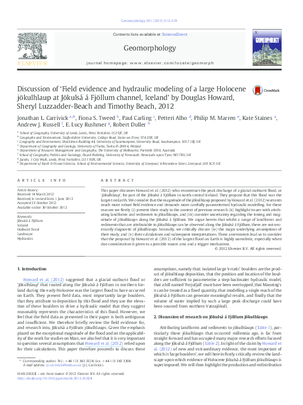
Fig. 1. Detail of flood limits around Ferjufjall (A) and of the north-eastern flanks of Herðubreið (B).
validity of their methods. As regards the imprecise writing, two statements need to be corrected immediately. Firstly, Howard et al. (2012)
referred to a 14 year-old paper by Miller and Cluer (1998) to say that
it is inconclusive whether the complexity of 2D modelling is justified
for palaeoflood analyses. Yet it is a fact that (i) technology has developed a lot since then and (ii) Alho and Aaltonen (2008) specifically
addressed this issue using the Jökulsá á Fjöllum as an example. Secondly, Howard et al. (2012) erroneously cited Carling et al. (2003)
with respect to the Missoula floods. They referred to an Altai flood
discharge of 18 × 10 6 m 3 s −1 and attributed this estimate to Herget
(2005). In fact, Herget (2005) recognised that the Baker et al.
(1993) estimate of 18 × 10 6 m 3 s −1 was based on a very limited number of cross sections that were within the location of the ice-dam
itself. Thus, Herget remodelled the Altai flood using revised multiple
cross sections located downstream of the ice dam and confirmed the
peak discharge as 10 × 10 6 m 3 s −1 using both 1D and 2D steadyflow methods. Note, Carling et al. (2010) recently revisited modelling
this Altai flood but with 1D and 2D unsteady-flow methods and, considering uncertainty, confirmed the peak discharge as most likely the
same as that estimated by Herget (2005).
Regarding the validity of the methods employed by Howard et al.
(2012), they stated in their second conclusion that their model results
correlated well with previous peak discharge estimates and flood
inundation maps and that this calibrates their model. No correlation
is presented, we are not told which previous studies or which peak
discharge estimates (several are given herein in Table 2), and in
step-backwater modelling PSI field data merely parameterises the
model. Furthermore, the step-backwater modelling method relies
on the model being iteratively altered to best-fit the PSI and so it is
therefore no surprise that the model correlates well with its input
data. Calibration of hydraulic modelling is a different process altogether and cannot be achieved by comparing model results to previous model results. Indeed, whilst they have a subsection entitled
‘errors and uncertainties’, there is (in our opinion) no such analysis.
The procedures used to set up the model are vague and there is no
uncertainty analysis of the PSIs. They seem to have adopted the default
expansion and contraction coefficient values without evaluation and a
reader is left hanging with the statement ‘which is consistent with the
approach used here.’ They vaguely state that they ‘use a range of
trimline heights that bound our observations…’ but does this mean
that they used the upper, lower or indeed the median values?
Howard et al. (2012) devoted a large proportion of their paper to
discussing Manning's n value as an input to their model and report the
use of different Manning's n values between 0.03 and 0.075 for channel and overbank sections. Ultimately, according to their Table 1, they
decided upon values of 0.035 and 0.065, which curiously are the same
as that used by Alho et al. (2005). Having the same values as Alho et al.
(2005) partly renders their lengthy discussion superfluous. More
importantly, whilst Howard et al. (2012) seemed to acknowledge
that they should have varied Manning's n in Section 3.4 they failed
to do this. This omission is a problem because the stage-dependant
nature of Manning's n is well known; by way of example, the paper
by Van et al. (2012) highlights the importance of varying Manning's
n as stage changes. Whilst Alho et al. (2005) used Manning's n values
for a flood of up to 40 m flow depth, Howard et al. (2012) suggested
floods of 160 m and 210 m deep. The fact that the longitudinal velocity (and hence power and shear stress) calculated by Howard et al.
(2012) in their Fig. 12 showed far less variability than that calculated
by Alho et al. (2005) in their Fig. 5 is further evidence of this ‘drowning’ of the effect of form roughness. Carrivick (2010) has recently
conducted a series of experiments that include an attempt to quantify
and to conceptualise some of the properties of relative roughness
in clear-water outburst floods. In our opinion, this problem with the
Manning's n specification, alongside the problems as described above
with the PSIs that parameterise the model, makes Howard et al.'s
(2012) fourth conclusion; an ‘upper limit’ peak discharge that is determined by hydraulic modelling based on sparse and few PSIs and on
incorrect Manning's n values, very doubtful.
Whereas Alho et al. (2005) modelled 140 km of the Jökulsá á
Fjöllum routeway and Alho et al. (2007) modelled 120 km of the
�J.L. Carrivick et al. / Geomorphology 201 (2013) 512–519
Jökulsá á Fjöllum routeway, Howard et al. (2012) only modelled a
24 km long reach of the middle part of the Jökulsá á Fjöllum (our
Fig. 2). This focus on a single reach in the middle of the routeway is
problematic because (i) hydraulics are exceptionally variable longitudinally, as emphasised by Figs. 5 and 6 of Alho et al. (2005) and more
recently in a study at Mt Ruapehu by Carrivick et al. (2009b, 2010),
and (ii) hydraulics modelled in a subcritical step-backwater model
entirely depend on the initiated downstream boundary conditions.
The Howard et al. (2012) model has no downstream PSI data, as
discussed above; the Möðrudalur PSI is outside of the model domain;
and the Ferjufjall location is not a PSI. The Howard et al. (2012) model
upstream boundary is at Herðubreið, and this cross section (like the
downstream boundary) does not represent the modelled reach in
terms of geometry; flow lines will not be parallel, and thus the assumption of hydrostatic distribution of pressure through this cross
section is violated. Therefore, the Howard et al. (2012) model is very
unlikely to satisfy the hydraulic assumptions of steady (in time) and
‘gradually-varied’ (in space) flow and will calculate erroneous head
loss between adjacent cross sections. This problem could explain
why Howard et al. (2012) have a water surface elevation change of
~ 100 m (from > 680 to ~ 580 m in their Fig. 12A), where channel elevation decreased by just ~ 30 m. For note, the model of Alho et al.
(2005) had the water surface gradient more or less matching the
channel gradient for the same reach. A direct comparison of longitudinal variation in peak discharge presented by Alho et al. (2005) and
Howard et al. (2012) is given in Fig. 2 to emphasise the discrepancies
between channel elevations and water surface elevations.
Overall, the modelling presented by Howard et al. (2012) seems to
have fallen for the very problems detailed by Carling et al. (2003),
whom they cite, but that are addressed more fully by Cao and
Carling (2002a,b), whom they do not cite. These are namely (and to
paraphrase) that ‘the quality of hydraulic models is often doubtful because of (i) poor assumptions in model formulation; (ii) simplified
numerical procedures; (iii) omission of sediment relationships or
implementation of sediment relationships of questionable validity;
and (iv) problematic model calibration and verification’.
7. Implications of the calculation of a very large peak discharge
When conducting palaeoflood studies of large floods it is necessary
to consider the implications of calculations of very large, albeit sudden, discharges (O'Connor and Baker, 1992). Calculating the peak discharge of a flood to be more than twice the peak discharge of any other
must give pause for thought on several counts. Firstly, the evidence
needs checking very carefully as discussed above. Secondly, a realistic
517
source and trigger needs to be identified to generate the necessary
volume and peak discharge. Regarding the first of these points, if a
flood of 22–45 × 10 6 m 3s −1 occurred it is hard to imagine how the
Jökulsá á Fjöllum landscape would look today. Alho et al. (2005),
Carrivick et al. (2004a,b) and Carrivick (2006, 2007a,b) have quantitatively linked jökulhlaup hydraulics along the Jökulsá á Fjöllum to
landforms and sediments matching flood geomorphology to ‘hydraulic envelopes’; usually flow depth / flow velocity ratios (Carrivick,
2007b). The same has been done for the Missoula palaeofloods by
O'Connor (1993), Benito (1997) and Alho et al. (2010), and for modern outburst floods at Mt. Ruapehu, New Zealand, by Carrivick et al.
(2009b, 2010). All of the hydraulic envelopes in these studies considered that both erosional and depositional landforms (i) belong to a hierarchy (e.g. Carrivick, 2007a,b); and (ii) evolve temporally (Carrivick
et al., 2011). The calculations of velocity and power produced by
Howard et al. (2012) are so far outside these established flow depth/
flow velocity ratio envelopes, that a flood of the magnitude suggested
might have simply comprised cavitation processes over the majority
of the routeway. Therefore, Howard et al. (2012) are implying that
the subtleties and variety of erosional and depositional landforms
and sediments that have been attributed to jökulhlaups along the
Jökulsá á Fjöllum (Table 1) must belong to smaller, late Holocene
jökulhlaups (Table 2); this is not supported by the geochronological
work that has been completed to date (e.g., Kirkbride et al., 2006)
(Table 2).
For the second point, Alho et al. (2007) built upon the work of
Alho et al. (2005) and determined that a hypothetical hydrograph
with a volume of one-third that of the Barðabunga caldera could produce a peak discharge of 0.18 × 10 m 3 s −1 along the Jökulsá á Fjöllum.
In contrast, Howard et al. (2012) appeared to make some rather unrealistic assumptions as to how a peak discharge of 2.2 − 4.5× 10⁷ m3 s−1
could have been produced. They do not give a volume estimate for
their reconstructed floods and so we here consider that because the
Altai 10× 10 6 m 3 s−1 flood had a total volume of ~695 km3 (Herget,
2005; Carling et al., 2010) by the same (albeit rough) scaling a reservoir
volume of ~1529 km3 would be needed to produce the (smaller)
22× 10 6 m 3 s−1 flood proposed by Howard et al. (2012). In their
Section 7, Howard et al. (2012) seemed to realise that there was a problem with finding this volume of water, but without any evidence at all
their suggestion of a combination of sources (including unsupported
hypotheses of extremely large proglacial lakes and subglacial lakes
as well as subglacial volcanism) is a very weak argument. This supposition is not a finding of their research and they give no citation for the
source of this information. Howard et al. (2012) did not suggest how
either individually or in combination all these lakes might have drained
Fig. 2. Comparison of bed elevation and water surface elevation suggested by Howard et al. (2012) and Alho et al. (2005) for large jökulhlaups along the Jökulsá á Fjöllum.
�518
J.L. Carrivick et al. / Geomorphology 201 (2013) 512–519
simultaneously. According to Björnsson and Pálsson (2008), the volume
of Vatnajökull in the year 2000 was 3100 km3, corresponding to
2790 km 3 of freshwater. Using our estimate of ~1529 km 3 of floodwater, the Howard et al. (2012) jökulhlaup would require (in a matter of
hours) about 55% of the present-day water-equivalent volume of
Vatnajökull. We wonder how that much ice could have been in the
Jökulsá á Fjöllum catchment at any stage during the Holocene? Furthermore, a flood of the magnitude suggested by Howard et al. (2012)
would have surely been detected in offshore deposits and it would
have increased global sea level by ~4 mm!
8. Conclusions
Overall, Howard et al. (2012) claimed to have found evidence of
the largest flood on Earth. In our opinion, a claim of that grandeur
and potential significance to understanding Icelandic landscapes requires very careful documentation of the evidence. We consider that
the genesis of large boulders used by Howard et al. (2012) as PSIs is
ambiguous. We suggest that the position and location of the boulders
is insufficient to parameterise a step-backwater hydraulic model and
that it remains unproven as to whether Ferjufjall was over-topped by
a flood because there is no evidence preserved there. We propose that
their modelling is flawed because Manning's n is treated as a fixed
quantity and because only a single middle reach of the Jökulsá á
Fjöllum is modelled and because the PSIs were insufficient in number
and quality. We are not convinced that Howard et al. (2012) provided
a convincing explanation for generating the volume of water necessary for such a large flood. We cannot envisage how such a large flood
could conceivably have been sourced and triggered from northern
Vatnajökull.
Acknowledgements
Matthew Roberts, Helgi Björnsson, and Vic Baker are thanked for
their knowledgeable comments on a draft of this manuscript.
References
Alho, P., 2003. Land cover characteristics in NE Iceland with special reference to
jökulhlaup geomorphology. Geografiska Annaler 85A (3–4), 213–227.
Alho, P., Aaltonen, J., 2008. Comparing a 1D hydraulic model with a 2D hydraulic model
for the simulation of extreme glacial outburst floods. Hydrological Processes 22,
1537–1547.
Alho, P., Russell, A.J., Carrivick, J.L., Käyhkö, J., 2005. Reconstruction of the largest
jökulhlaup within Jökulsá á Fjöllum river, NE Iceland during Holocene. Quaternary
Science Reviews 24, 2319–2334.
Alho, P., Roberts, M.J., Käyhkö, J., 2007. Estimating the inundation area of a massive,
hypothetical jökulhlaup from northwest Vatnajökull, Iceland. Natural Hazards 41, 21–42.
Alho, P., Baker, V.R., Smith, L.N., 2010. Paleohydraulic reconstruction of the largest
Glacial Lake Missoula draining(s). Quaternary Science Reviews 29, 3067–3078.
Angelier, J., Bergerat, F., Dauteuil, O., Villemin, T., 1997. Effective tension-shear relationships in extensional fissure swarms, axial rift zone of northeastern Iceland. Journal
of Structural Geology 19, 673–685.
Arnalds, O., Gisladottir, F.O., Orradottir, B., 2011. Determination of aeolian transport
rates of volcanic soils in Iceland. Geomorphology 167–168, 4–12.
Ashwell, I.Y., 1986. Meteorology and duststorms in central Iceland. Arctic and Alpine
Research 18, 223–234.
Baker, V.R., 2002. High-energy megafloods: planetary settings and sedimentary dynamics.
In: Martini, P., Baker, V.R., Garzon, G. (Eds.), Flood and Megaflood Processes and
Deposits: Recent and Ancient Examples. : IAS Special Publication, 32. Blackwell, Oxford,
UK, pp. 3–15.
Baker, V.R., Benito, G., Rudoy, A.N., 1993. Palaeohydrology of late Pleistocene superflooding,
Altay Mountains, Siberia. Science 259, 348–350.
Benito, G., 1997. Energy expenditure and geomorphic work of the cataclysmic Missoula
flooding in the Columbia River gorge, USA. Earth Surface Processes and Landforms
22, 457–472.
Benn, D.I., Evans, D.J.A., 1998. Glaciers and Glaciation. Arnold, London, (734 pp.).
Benn, D.I., Evans, D.J.A., 2010. Glaciers and Glaciation. Hodder Education, London, UK.
(816 pp.).
Björnsson, A., 1985. Dynamics of crustal rifting in NE Iceland. Journal of Geophysical
Research 90 (B12), 10151–10162.
Björnsson, H., Pálsson, F., 2008. Glaciers in Iceland. Jökull 58, 365–386.
Bourgeois, O., Dauteuil, O., Van Vliet-Lanoe, B., 1998. Pleistocene subglacial volcanism
in Iceland: tectonic implications. Earth and Planetary Science Letters 164, 165–178.
Cao, Z., Carling, P.A., 2002a. Mathematical modelling of alluvial rivers: reality and myth.
Part 1: general review. Water and maritime engineering. Proceedings of the Institution
of Civil Engineers 154, 207–219.
Cao, Z., Carling, P.A., 2002b. Mathematical modelling of alluvial rivers: reality and
myth. Part 2: special issues. Water and maritime engineering. Proceedings of the
Institution of Civil Engineers 154, 297–307.
Carling, P.A., Kidson, R., Cao, Z., Herget, J., 2003. Palaeohydraulics of extreme flood
events: reality or myth. In: Gregory, K.J., Benito, G. (Eds.), Palaeohydrology; Understanding Global Change. Wiley, Chichester, UK, pp. 325–336.
Carling, P.A., Burr, D.M., Johnson, T.F., Brennand, T.A., 2009. A review of open-channel
megaflood depositional landforms on Earth and Mars. In: Burr, D.M., Carling, P.A.,
Baker, V.R. (Eds.), Megaflooding on Earth and Mars. Cambridge University Press,
Cambridge, UK.
Carling, P.A., Villanueva, I., Herget, J., Wright, N., Borodavko, P., Morvan, H., 2010.
Unsteady 1D and 2D hydraulic models with ice dam break for Quaternary megaflood,
Altai Mountains, southern Siberia. Global and Planetary Change 70, 24–34.
Carrivick, J.L., 2005. Characteristics and impacts of jökulhlaups (glacial outburst floods)
from Kverkfjöll, Iceland. unpublished PhD thesis (Keele University).
Carrivick, J.L., 2006. 2D modelling of high-magnitude outburst floods; an example from
Kverkfjöll, Iceland. Journal of Hydrology 321, 187–199.
Carrivick, J.L., 2007a. Modelling coupled hydraulics and sediment transport of a highmagnitude flood and associated landscape change. Annals of Glaciology 45, 143–154.
Carrivick, J.L., 2007b. Hydrodynamics and geomorphic work of jökulhlaups (glacial outburst floods) from Kverkfjöll volcano, Iceland. Hydrological Processes 21, 725–740.
Carrivick, J.L., 2009. Jökulhlaups from Kverkfjöll volcano, Iceland: modelling transient
hydraulic phenomena. In: Burr, D.M., Carling, P.A., Baker, V.R. (Eds.), Megaflooding
on Earth and Mars. Cambridge University Press, Cambridge, UK, pp. 273–289.
Carrivick, J.L., 2010. Dam break — outburst flood propagation and transient hydraulics:
a geosciences perspective. Journal of Hydrology 380, 338–355.
Carrivick, J.L., 2011. Jökulhlaups: geological importance, deglacial association and
hazard management. Geology Today 27, 133–140.
Carrivick, J.L., Rushmer, E.L., 2006. Understanding high-magnitude outburst floods.
Geology Today 22, 60–65.
Carrivick, J.L., Twigg, D., 2005. Jökulhlaup-influenced topography and geomorphology
at Kverkfjöll, Iceland. Journal of Maps 2005, 17–27.
Carrivick, J.L., Russell, A.J., Tweed, F.S., Twigg, D., 2004a. Palaeohydrology and sedimentology of jökulhlaups from Kverkfjöll, Iceland. Sedimentary Geology 172, 19–40.
Carrivick, J.L., Russell, A.J., Tweed, F.S., 2004b. Geomorphological evidence for
jökulhlaups from Kverkfjöll volcano, Iceland. Geomorphology 63, 81–102.
Carrivick, J.L., Pringle, J.K., Russell, A.J., Cassidy, N.J., 2007. GPR-derived sedimentary
architecture and stratigraphy of outburst flood sedimentation within a bedrock valley
system, Hraundalur, Iceland. Journal of Environmental and Engineering Geophysics
12, 127–143.
Carrivick, J.L., Russell, A.J., Rushmer, E.L., Tweed, F.S., Marren, P.M., Deeming, H., Lowe,
O.J., 2009a. Geomorphological evidence towards a deglacial control on volcanism.
Earth Surface Processes and Landforms 34, 1164–1178.
Carrivick, J.L., Manville, V., Cronin, S., 2009b. Modelling the March 2007 lahar from Mt
Ruapehu. Bulletin of Volcanology 71, 153–169.
Carrivick, J.L., Manville, V., Graettinger, A., Cronin, S., 2010. Coupled fluid dynamicssediment transport modelling of a Crater Lake break-out lahar: Mt. Ruapehu,
New Zealand. Journal of Hydrology 388, 399–413.
Carrivick, J.L., Jones, R., Keevil, G., 2011. Experimental insights towards geomorphic
processes within dam break outburst floods. Journal of Hydrology 408, 153–163.
Cassidy, N.J., Russell, A.J., Pringle, J.K., Carrivick, J.L., 2004. GPR-derived architecture of
large-scale icelandic Jökulhlaup deposits, North-East Iceland. In: Slob, E., Yarovoy,
A., Rhebergen, J. (Eds.), Proceedings of the Tenth International Conference on Ground
Penetrating Radar, June 21–24, 2004. DELFT, The Netherlands, pp. 581–584.
Chapman, M.G., Hare, T.M., Russell, A.J., Guðmundsson, M.T., 2003. Possible Juventae
Chasma subice volcanic eruptions and Maja Valles ice outburst floods on Mars:
implications of Mars Global Surveyor crater densities, geomorphology, and topography. Journal of Geophysical Research 108, 5113.
Dauteuil, O., Angelier, J., Bergerat, F., Verrier, S., Villemin, T., 2001. Deformation
partitioning inside a fissure swarm of the northern Icelandic rift. Journal of Structural
Geology 23, 1359–1372.
de Ruyter de Wildt, M.S., Klok, E.J., Oerlemans, J., 2003. Reconstruction of the mean specific mass balance of Vatnajökull (Iceland) with a seasonal sensitivity characteristic.
Geografiska Annaler 85A, 57–72.
Garcia, S., Arnaud, N.O., Angelier, J., Bergerat, F., Homberg, C., 2003. Rift jump process in
northern Iceland since 10 Ma from 40Ar/39Ar geochronology. Earth and Planetary
Science Letters 214, 529–544.
Geirsdóttir, A., Eiriksson, J., 1994. Growth of an intermittent ice sheet in Iceland during
the Late Pliocene and early Pleistocene. Quaternary Research 42, 115–130.
Geirsdóttir, Á., Miller, G.H., Axford, Y., Ólafsdóttir, S., 2009. Holocene and latest Pleistocene climate and glacier fluctuations in Iceland. Quaternary Science Reviews 28,
2107–2118.
Guðmundsson, H.J., 1997. A review of the Holocene environmental history of Iceland.
Quaternary Science Reviews 16, 81–92.
Guðmundsson, A., 2000. Dynamics of volcanic systems in Iceland: example of tectonism and volcanism at juxtaposed hot spot and mid-ocean ridge systems. Annual
Review of Earth and Planetary Sciences 28, 197–240.
Helgason, J., 1984. Frequent shifts of the volcanic zone in Iceland. Geology 12, 212–216.
Helgason, J., 1987. Jarðfræðirannsóknir á Vatnasviði Jökulsár á Fjöllum við Möðrudal.
Report OS-87005/VOD-01: Orkustofnun Reykjavík.
Herget, J., 2005. Reconstruction of Pleistocene ice-dammed lake outburst floods in the
Altai Mountains, Siberia. Special Paper 386, U.S. Geological Society of America.
(118 pp.).
�J.L. Carrivick et al. / Geomorphology 201 (2013) 512–519
Hooper, A., Ófeigsson, B., Sigmundsson, F., Lund, B., Einarsson, P., Geirsson, H., Sturkell,
E., 2011. Increased capture of magma in the crust promoted by ice-cap retreat in
Iceland. Nature Geoscience 4, 783–786.
Hovius, N., Lea-Cox, A., Turowski, J.M., 2008. Recent volcano–ice interaction and outburst flooding in a Mars polar cap re-entrant. Icarus 197, 24–38.
Howard, D., Luzzadder-Beach, S., Beach, T., 2012. Field evidence and hydraulic modeling of a large Holocene jökulhlaup at Jökulsá á Fjöllum channel, Iceland. Geomorphology 147–148, 73–85.
Hubbard, A., Sugden, D., Dugmore, A., Norddahl, H., Pétursson, H.G., 2006. A modelling
insight into the Icelandic Last Glacial Maximum ice sheet. Quaternary Science
Reviews 25, 2283–2296.
Ingólfsson, Ó., 1994. A review of the environmental history of Iceland, 13,000–9000 yr
BP. Journal of Quaternary Science 9, 147–150.
Käyhkö, J., Alho, P., Hendriks, J.P.M., Rossi, M., 2002. Geomorphological processes and land
degradation in Ódaðahraun semi-desert, north-eastern Iceland. Jökull 51, 1–16.
Kirkbride, M.P., Dugmore, A.J., 2001. Timing and significance of mid-Holocene glacier
advances in northern and central Iceland. Journal of Quaternary Science 16, 145–153.
Kirkbride, M.P., Dugmore, A.J., 2006. Responses of mountain lee caps in central Iceland
to Holocene climate change. Quaternary Science Reviews 25, 1692–1707.
Kirkbride, M.P., Dugmore, A.J., Brazier, V., 2006. Radiocarbon dating of mid-Holocene
megaflood deposits in the Jökulsá á Fjöllum, Iceland. The Holocene 16, 605–609.
Knudsen, Ó., Russell, A.J., 2002. Jökulhlaup deposits at the Ásbyrgi Canyon, northern Iceland:
sedimentology and implications for flow type. In: Snorrason, A., Finnsdóttir, A.P., Moss,
M. (Eds.), The Extremes of the Extremes: Extraordinary Floods. : Proc. of a Symp. July
2000 Reykjavík, Publ. No. 271. IAHS Press, Wallingford, Oxfordshire, UK, pp. 107–112.
Maclennan, J., Jull, M., McKenzie, M., Slater, L., Grönvold, K., 2002. The link between
volcanism and deglaciation. Geochemistry, Geophysics, Geosystems 3, 1–25.
Malin, M.C., Eppler, D.B., 1981. Catastrophic floods of the Jökulsá á Fjöllum, Iceland. Reports of Planetary Geology Program — 1981, NASA Technical Memorandum 84211,
Government Printing Office, Washington D.C (272–273 pp.).
Marren, P.M., 2002. Criteria for identifying high magnitude flood events in the
proglacial fluvial sedimentary record. In: Snorrason, Á., Finnsdóttir, H.P., Moss, M.
(Eds.), The Extremes of the Extremes: Extraordinary Floods: IAHS Publication,
271, pp. 237–241 (Wallingford, Oxfordshire, UK).
Marren, P.M., 2005. Magnitude and frequency in proglacial rivers: a geomorphological
and sedimentological perspective. Earth-Science Reviews 70, 203–251.
Marren, P.M., Schuh, 2009. Criteria for identifying jökulhlaups in the sedimentary
record. In: Burr, D., Baker, V.R., Carling, P. (Eds.), Megaflooding on Earth and
Mars. Cambridge University Press, Cambridge, UK, pp. 225–242.
519
Miller, A.J., Cluer, B.L., 1998. Modeling considerations for simulation of flow in bedrock
channels. In: Tinkler, K.J., Wohl, E.E. (Eds.), Rivers over Rock: Fluvial Processes in
Bedrock Channels. American Geophysical Union, Washington D.C., pp. 61–104.
Norðdahl, H., 1990. Late Weichselian and early Holocene de-glaciation history of Iceland.
Jökull 40, 27–50.
O'Connor, J.E., 1993. Hydrology, hydraulics and geomorphology of the Bonneville Flood.
Special Papers 274, U.S. Geological Society of America, Boulder, Colorado. (83 pp.).
O'Connor, J.E., Baker, V.R., 1992. Magnitudes and implications of peak discharges from
glacial Lake Missoula. Geological Society of America Bulletin 104, 267–279.
Ólafsdóttir, R., Guðmundsson, H.J., 2002. Holocene land degradation and climatic
change in northeastern Iceland. The Holocene 12, 159–167.
Sæmundsson, K., 1973. Straumrákaðarklappir í kringum Ásbyrgi. Náttúrufræðingurinn
43, 52–60.
Slater, L., Jull, M., McKenzie, D., Gronvold, K., 1998. Deglaciation effects on mantle melting under Iceland: results from the northern volcanic zone. Earth and Planetary
Science Letters 164, 151–164.
Stokes, C.R., Clark, C.D., 1999. Geomorphological criteria for identifying Pleistocene ice
streams. Annals of Glaciology 28, 67–74.
Stokes, C.R., Clark, C.D., 2001. Palaeo-ice streams. Quaternary Science Reviews 20,
1437–1457.
Thórarinsson, S., 1950. Glacier outbursts in the river Jökulsá a Fjöllum. Náttúrufræðingurinn
20, 113–133.
Thórarinsson, S., 1959. Some geological problems involved in the hydroelectric development of the Jökulsá á Fjöllum. Report to the State Electricity Authority, Reykjavík,
Iceland (35 pp.).
Tómasson, H., 1973. Hamfarahlaup í Jökulsá a Fjöllum. Náttúrufræðingurinn 43, 12–34.
Tómasson, H., 2002. Catastrophic floods in Iceland. In: the extremes of the extremes:
extraordinary floods. In: Snorrason, A., Finnsdóttir, A.P., Moss, M. (Eds.), Proc. of
a Symp. July 2000, Reykjavík, Publ. no. 271. IAHS Press, Wallingford, Oxfordshire,
UK, pp. 121–126.
Van, T.P., Carling, P.A., Atkinson, P.M., 2012. Modelling the bulk flow of a bedrockconstrained, multi-channel reach of the Mekong River, Siphandone, southern
Laos. Earth Surface Processes and Landforms 37 (5), 533–545.
Waitt, R.B., 1998. Cataclysmic flood along Jökulsá á Fjöllum, north Iceland, compared to
repeated colossal jökulhlaups of Washington's channelled scabland. 15th Int.
Sedimentol. Congr., Alicante, Abstracts, pp. 811–812.
Waitt, R.B., 2002. Great Holocene floods along Jökulsá á Fjöllum, north Iceland. In:
Martini, P., Baker, V.R., Garzon, G. (Eds.), Flood and Megaflood Processes and Deposits:
Recent and Ancient Examples: IAS Special Publication, 32, pp. 37–51 (city, country).
�
 Jonathan Carrivick