Tectonophysics 508 (2011) 62–72
Contents lists available at ScienceDirect
Tectonophysics
j o u r n a l h o m e p a g e : w w w. e l s ev i e r. c o m / l o c a t e / t e c t o
Crustal structure and extensional deformation of thinned lithosphere in
Northern China
Zhongjie Zhang a,⁎, Qifu Chen b, Zhiming Bai a, Yong Chen b, José Badal c
a
b
c
State Key Laboratory of Lithospheric Evolution, Institute of Geology and Geophysics, Chinese Academy of Sciences, Beijing 100029, China
Institute of Earthquake Science, China Earthquake Administration, Beijing 100036, China
Physics of the Earth, Sciences B, University of Zaragoza, Pedro Cerbuna 12, 50009 Zaragoza, Spain
a r t i c l e
i n f o
Article history:
Received 15 January 2009
Received in revised form 29 June 2010
Accepted 30 June 2010
Available online 7 July 2010
Keywords:
North China Plain
Yanshan Mountain Folded Belt
Crustal structure
Lithosphere thinning
Extensional factor
a b s t r a c t
We herein present an interpretation of a 320 km-long wide-angle seismic profile between Anxin and
Kuancheng, which was obtained in 2002. The profile runs from the North China Plain (NCP), where the
lithosphere is just 70 km thick; to the Yanshan Mountain Folded Belt (YMFB), where the lithosphere
is180 km thick. Our model shows a crustal thickness that varies from 31 km under the NCP to 36 km under
the YMFB. The observed thinning of the crust in the NCP is about 14%, which compares with an average
extension of 24–41% at basin-scale and 25% at lithosphere-scale. This finding suggests that the extensional
deformation of the lithosphere in the North China block depends on depth. The thin, high-velocity crust–
mantle transition zone has most likely originated after a delamination of the bottom of the crust and a
concomitant intrusion of materials from the mantle. The lower velocity of the lower crust may be attributed
to the destruction of the lithosphere, which permitted the lateral flow of melting materials above the Moho
from the NCP to the YMFB. The differences found between the crust and the lithospheric mantle help to
dispel any of the remaining uncertainty in the extensional factors, and they may be attributed to detachment
of middle crust and an intrusion of magma that originated in either lithosphere or asthenosphere. We infer
that the detachment of the middle crust, lower-crustal flow and magma intrusion probably lead to the
underestimation of the crustal-scale extensional factor, and may represent the crustal response to the
thinning of the lithosphere.
© 2010 Elsevier B.V. All rights reserved.
1. Introduction
The North China block is one of the oldest continental nuclei in the
world (Jahn and Nyquist, 1976), and consists of two Archean blocks,
namely the western and the eastern, which have reported crustal ages
of 3.8 Ga (Liu, 1992), separated by a Proterozoic orogenic belt of
1.8 Ga (Zhao et al., 2000). The thickness of the lithosphere beneath the
Precambrian shield is generally considered to be 185 km, with
mechanical and thermal boundary layer thicknesses of about 165
and 36 km, respectively (White and McKenzie, 1988; McKenzie and
Nimmo, 1997). Ever since the Cenozoic, the North China Craton has
been fragmented by intensive intracontinental rifting and extensional
tectonics, which have resulted in the formation of two extensional
domains, namely the western domain, characterised by graben
systems around the Ordos basin, and the eastern domain, represented
by the North China Plain (NCP; Zhang et al., 2003). The rifting and
extensional tectonics have worked to induce thinning of the
⁎ Corresponding author. Tel.: +86 10 82998313; fax: +86 10 82998229.
E-mail address: zjzhang1@yahoo.com (Z. Zhang).
0040-1951/$ – see front matter © 2010 Elsevier B.V. All rights reserved.
doi:10.1016/j.tecto.2010.06.021
lithosphere in the eastern domain, while thicker lithosphere has
been preserved in the older western domain.
It has been estimated from geochemical data that the lithosphere
is as much as 200 km thick in the western block, but only 80 km thick
in the eastern block (Fan et al., 2000). Apart from the thickness, also
the lateral heterogeneity (Ma, 1987) and the composition (Zhang
et al., 2003) of the lithosphere differ between the two blocks. Gravity
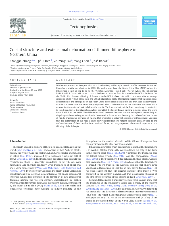
data inversion (Ma, 1987; Yuan, 1996) indicates that the lithosphere
is around 100 km thick in the western domain, but shows large
variations in thickness of 60–100 km in the eastern domain (Fig. 1). It
has been suggested that the original cratonic lithosphere is well
preserved in the western domain, and that pronounced thinning of
the lithosphere occurred in the eastern domain (Zhai et al., 2007).
Seismic data acquired from passive seismogenic sources show that
the thickness of the lithosphere varies considerably in the eastern
domain (Ma, 1987; Yuan, 1996; Li and Mooney, 1998; Deng et al.,
2004; Huang and Zhao, 2004). For example, surface wave modelling
has shown that the thickness is almost 80 km at the southwestern end
(38.5°N) of the Anxin–Kuancheng wide-angle seismic profile (Fig. 1),
and approximately 180 km at the northeastern end (41.5°N) of the
profile in the eastern block of the North China Craton (Griffin et al.,
1998; Lebedev and Nolet, 2003; Deng et al., 2004; Huang and Zhao,
�Z. Zhang et al. / Tectonophysics 508 (2011) 62–72
63
Fig. 1. Thickness of the crust (red isolines) and lithosphere (blue isolines) on an elevation map (Yuan, 1996; Li and Mooney, 1998). The straight line running in a NE–SW direction
(green line) marks the deep seismic sounding profile studied herein. YMFB is the Yanshan Mountain Folded Belt, THSU is the Taihangshan uplift, and NCP is the North China Plain.
The inset in the lower right-hand corner indicates the location of the study area with respect to the rest of China. The small box indicates the location of the study area.
2004; Kusky et al., 2007). However, it should be noted that the
thickness of the crust along the Anxin–Kuancheng profile barely
changes, even though the topography drops from an average surface
elevation of 1 km above sea level in the northeastern region to less
than 500 m in the southwestern region (Li and Mooney, 1998; Li et al.,
2004; Zheng et al., 2006).
By taking the top of the high-conductivity layer as the bottom of
the lithosphere (Wei et al., 2006), the magnetotelluric data suggest
that the thickness of the lithosphere along the Anxin–Kuancheng
profile changes very little, from 60 km under the southwest end to
almost 55 km under the northeast end, which contradicts previous
findings. Later on, we will assume that the high-conductivity zone
represents a huge intrusion that originates from the asthenosphere.
Using geophysical data, Ma (1987) identified a northeast–
southwest gravity lineament (Fig. 1) between the Taihangshan uplift
(THSU) and the North China Plain (NCP) that divides the North China
Craton into different tectonic domains (Fig. 1). The region to the west
of this gravity lineament is characterised by large negative Bouguer
anomalies and a lithospheric thickness of 150–220 km. The region to
the east of the lineament is characterised by weak negative/positive
gravity anomalies, a high heat flow, and a lithospheric thickness of
60–120 km. These Bouguer gravity anomalies show a rapid increase
from −100 to −40 and −20 mGal, over a narrow band in the west–
east direction. Mesozoic magmatism occurs mainly to the east of the
gravity lineament. It is characterised by voluminous felsic tointermediate intrusion (predominantly monzonitic) and associated
mafic bodies, together with widespread volcanic counterparts. To the
west, the magmatism and basin development are less pronounced
(Ma, 1987; Ai and Zheng, 2003; Ai et al., 2003, 2008; Chen et al.,
2008).
Spatial (and temporal) variations in lithospheric thickness can
provide significant constraints on the evolution of the lithosphere. The
seismic survey line that follows the Anxin–Kuancheng transect
(Fig. 1) crosses the study area, and offers one of the best opportunities
for investigating the seismic velocity structure of the crust and the
evolution of the lithosphere in Northern China. In this paper, we
present our interpretation of the velocities in the Anxin–Kuancheng
seismic profile. Below, we discuss the structural response to
lithospheric thinning at different scales, namely those of the basin,
crust and deep lithosphere. We also describe the related coupling–
decoupling deformation as the key geodynamic mechanism in the
NCP.
2. Tectonic setting
The Anxin–Kuancheng profile is situated to the east of the gravity
lineament and crosses two tectonic subunits in a SW–NE direction,
namely the NCP to the southwest and the Yanshan Mountain Folded
Belt (YMFB) to the northeast (Fig. 2). Within the NCP, various
Cenozoic basins of different thicknesses lie along the profile from SW
to NE, namely the Jizhong depression, the Baoding depression, the
Niutuozhen uplift, the Guan depression, and the Beijing–Tianjing
depression (Li, 1981; Ye et al., 1985, 1987; Liu, 1988). The North China
basins endured NW–SE shear-compression during the Early Cenozoic,
forming incipient faults (Li, 1981; Ye et al., 1985, 1987; Liu, 1988). A
number of active faults exist in the North China basin (Fig. 2); all the
tectonic structures are oriented in the NE–SW direction. Since the
Mid-Cenozoic, the region has experienced extension, crustal rise and
faulting, and widespread extension of the upper and middle crust took
place during right-lateral extensional shearing. The delamination of
the lithosphere occurred during the Late Tertiary, and resulted in a
thinner lithosphere and the present tectonic setting of the NCP. The
NCP is surrounded by large-scale normal faults that cross the interior
of the block and stretch in a NE direction. To the north of the Baodi–
�64
Z. Zhang et al. / Tectonophysics 508 (2011) 62–72
Fig. 2. Location of the Anxin–Kuancheng wide-angle seismic profile shown on a geological map (Zhang, 1984). The triangles and stars mark, respectively, the geographical positions
of the stations and shot points at Anxin, Anci, Sanhe, and Zunhua. The dashed lines depict the faults F1, Zhangjiakou–Beipiao fault; F2, Huailai–Zhuozhou fault; F3, Dacheng fault; F4,
Cangdong fault; F5, Baodi–Tongbai fault; F6, Jiyunhe fault; F7, Ninghe–Changli fault; F8, Laishui fault. The other formations shown are: I, Jizhong depression; II, Rongxian uplift; III,
Cangxian uplift; IV, Daxing uplift; V, Huanghua depression.
Tongbai fault (Fig. 2), the YMFB formed in the Archean Eon, and was
reactivated during the Phanerozoic Eon and hosts a series of
intermountain depressions, and were later folded by the Mesozoic
orogeny (called as Yanshanian movement in earth science community
of China).
3. Data acquisition
The P-wave seismic data used in our study were acquired from a
320 km-long wide-angle reflection–refraction profile obtained during
April and May 2002. The Geophysical Exploration Center, China
Earthquake Administration carried out the fieldwork. The profile had
its azimuth at approximately N30°E, and ran between Anxin and
Kuancheng, Heibei Province. Shots were fired at the four sites: Anxin,
Anci, Sanhe and Zunhua, with an average shot spacing of 80–100 km
(Fig. 2). For each shot, 4–8 holes were drilled to a depth of about 20 m
and loaded with 1200–2200 kg of explosive charge. A total of 100
portable three-component digital meters/geophones were used to
acquire seismic data along a long-offset profile. The station spacing
was 3 km. The three-minute-long seismic signals were initially
sampled at a rate of 200 sps, and then band-pass filtered within the
1–10 Hz frequency band for P-waves. Figs. 3a, 4a, 5a, and 6a show the
traces of the crustal P-phases using a reduction velocity of 6.0 km/s.
The refractions above the crystalline basement of the crust (the Pgphase) and the reflections from the Moho (the PmP- or simply Pmphase) can be easily correlated in the following section we focus our
attention mainly on the Pg and Pm arrivals. Our preliminary
assessment of the records shows that the most conspicuous
characteristics of the wide-angle seismic dataset seem to be:
(a) very strong Pm reflections from the crust–mantle boundary;
(b) clear differences between the intra-crustal reflections, labelled P2,
P3 and P4, when these originate from progressively deeper interfaces,
from different shot points (Figs. 3a, 4a, 5a, and 6a). Relatively welldeveloped intra-crustal reflections are apparent from the shots at
Anxin and Anci, with poorly developed reflections are observed from
the shots at Sanhe and Zunhua.
The first Pg arrivals may generally be observed at offsets up to
90 km, although shorter distances are recorded in the southern
branch of the Sanhe shot (Fig. 5a). From this shot, Pg arrivals with
weak energy can be inter-correlated at offsets up to 90 km to the
south, as can the ones with strong energy up to 110 km to the north.
The Pg travel times are delayed in the southern branch of the Sanhe
shot, but they vary greatly in the northern branch, for which the timeoffset curve is a horizontal straight line. These characteristics
demonstrate that the apparent P-wave velocity is less than 6.0 km/s
to south, being as low as 4.2 km/s or even lower, but that it is generally
higher, nearly 6.0 km/s, to the north of Sanhe. Since the Pg travel
times are concave upward in the southern transect of the Anxin shot
(Fig. 3a) and on both sides of the Anci shot (Fig. 4a), the thickness of
the sedimentary layers appears to be thicker to the south of Sanhe
than to the north of it. This finding indicates a strong lateral variation
in the thickness of the uppermost layers.
The Pm-phase reflected from the Moho is clear in all records, and
may generally be inter-correlated at offsets greater than 70–80 km
�Z. Zhang et al. / Tectonophysics 508 (2011) 62–72
65
Fig. 3. Upper panel (a): Vertical-component P-wave record section from shot fired at Anxin, shown with a reduction velocity of 6.0 km/s. The crustal phases are identified and
labelled as follows: Pg-phase, refraction above the crystalline basement of the crust; Pm-phase, reflection from the Moho; P2, P3 and P4, reflections from the intra-crustal interfaces.
The points shown in black represent the selected data and the continuous lines show the calculated travel times. Middle panel (b): Synthetic P-wave amplitudes and travel times.
Lower panel (c): Illumination of the crust by ray coverage.
(Figs. 3a, 4a, 5a, and 6a), although only up to 60 km following the
northern branch of the Zunhua shot (Fig. 6a). The reduced travel time
curves show the influence of the shallow thick sedimentary layers, but
the lateral velocity variations in the crust are more difficult to see.
Reflection events (labelled as P2 in Figs. 3a, 4a, 5a, and 6a) from a
crustal interface delineate the upper crust. Other reflection events
from deeper interfaces above the crust–mantle discontinuity (labelled
as P3 and P4) delineate the middle crust. These events are all marked
on the record sections for clarity.
The subcrustal Pn-phase refracted from the uppermost part of the
upper mantle may also be recognised at offsets greater than 150 km,
although their amplitudes are rather weak. An example is shown from
the northern branch of the Anci shot (Fig. 3a).
4. Data inversion and reliability tests
The P-wave velocity model between Anxin and Kuancheng was
obtained using a finite-difference approach to calculate the travel
times (Vidale, 1988; Ammon and Vidale, 1993) and a depth-to-layer
interface inversion from the reflected phases (Hole and Zelt, 1996).
The first step in the procedure (a) is the modelling of the upper crust
(~0–15 km depth) using only velocities and an inversion of selected
Pg data. The second step (b) is the determination of the middle- and
lower-crustal velocities by inversion of the Pn travel times. The third
step (c) is the depth-to-layer interface inversion from the Pm-phase
and the intra-crustal reflections P2, P3 and P4 (Hole and Zelt, 1996), in
combination with interactive forward ray-tracing (Luetgert, 1988),
while preserving the middle- and lower-crustal velocities as previously determined from the Pn travel times. After constraining the
upper- and middle-crustal velocities, we interactively derived the
depth and morphology of the Moho, and simultaneously refined the
lower-crustal velocities obtained from the Pm-phase. The implementation of the procedure therefore requires the use of both an
interactive ray-tracing method (Luetgert, 1988) and a finite-difference depth-to-layer interface inversion scheme (Hole and Zelt, 1996)
to model the P2, P3, P4, Pm, and Pn arrivals and the Moho depth.
4.1. Synthetics
Synthetic seismograms for the four shots fired at Anxin, Anci,
Sanhe, and Zunhua were computed from the final velocity model
(shown later in Fig. 10) using the 2D travel time inversion codes (Zelt
and Smith, 1992). These are all shown in Figs. 3b, 4b, 5b, and 6b, and it
may be seen that the results reproduce the observed data rather well.
The goodness of the fit between the travel times selected and those
calculated for all shot gathers may be seen in the upper panels of
Fig. 3.
4.2. Ray coverage
The reliability of the final velocity model initially depends on the
spacing of the shot points, the number of installed receivers, the
density of the seismic rays, and the type and quality of the arrivals
identified. It may be assumed that the model is constrained well by all
these factors. Nevertheless, the partial illumination of the crust by ray
coverage along the wide-angle seismic profile is shown in Figs. 3c, 4c,
5c, and 6c. The complete illumination of the crust by refractions above
the crystalline basement and intra-crustal reflections along the
transect are shown in Fig. 7b. Most of the crust is sufficiently covered
by seismic rays, except the zones to the extreme north and south of
the profile. Those portions that are not covered by seismic rays, or that
are insensitive to changes in the crustal parameters, are not taken into
�66
Z. Zhang et al. / Tectonophysics 508 (2011) 62–72
Fig. 4. Upper panel (a): Vertical-component P-wave record section from the shot fired at Anci, shown with a reduction velocity of 6.0 km/s. The crustal phases are identified and
labelled as follows: Pg-phase, refraction above the crystalline basement of the crust; Pm-phase, reflection from the Moho; P2, P3 and P4, reflections from the intra-crustal interfaces.
The points shown in black represent the selected data and the continuous lines show the calculated travel times. Middle panel (b): Synthetic P-wave amplitudes and travel times.
Lower panel (c): Illumination of the crust by ray coverage. The refracted phase from the uppermost part of the upper mantle is labelled as Pn.
account in our interpretation. Fig. 7a shows the comparison between
the selected and calculated P-wave travel times obtained by forward
computation from our final crustal velocity model (shown later in
Fig. 10).
low velocity anomalies) and the geometry (the boundaries) are
sufficiently well resolved in almost everywhere in the crust described
herein, only the zones to the extreme north and south of the profile
are less-well-resolved, as may be expected.
4.3. Checkerboard test
5. Crustal model along the Anxin–Kuancheng transect
Smearing effects, due to an insufficiency of seismic rays, may be
present and may even affect the spatial resolution. In order to assess
the influence of these effects, we have used a conventional
checkerboard test, in which the inversion of synthetic data from an
input model was carried out using a regular pattern of alternating
velocity perturbations and laterally varying depths, so that the
similarity between the output inversion model and the input model
was then taken as an estimate of the spatial resolution (Zelt and
Barton, 1998). Because the seismic velocities contain errors that are
often somewhat smaller than those that affect the depths of the layers,
we have assumed that the velocities are accurate to within 3%,
whereas the boundaries, including the Moho depth, are accurate to
within 10% (Mooney and Braile, 1989). Keeping in mind these limits,
we show (Fig. 8a) a theoretical configuration, similar to a checkerboard, obtained using trial P-velocity perturbations of ±0.2 km/s and
trial depths of ±0.5 km, assigned to nodes distributed uniformly over
the whole of the structure in question. These velocity and depth
perturbations are all consistent with the model concerned. For a given
spacing of shot points and station array, both the travel times and the
layer depths were computed from this input model by forward
modelling, being subsequently inverted to give the output model
shown in Fig. 8b. The comparison between the input and recovered
models (Fig. 8) allows an assessment of the directions in which
smearing takes place. It is shown that both the lithology (the high and
An overall view of the results may be seen in Fig. 9, in which the Pwave velocity model along the Anxin–Kuancheng profile in Northern
China is shown. At first glance, both the sedimentary cover and the
upper crust have laterally variable thicknesses throughout the profile.
The sedimentary lid is extremely thick beneath Anci, with a maximum
thickness of ~ 6 km. In contrast, a very thin layer (only 1 km) is found
in the northeastern segment of the profile between Zunjua and Sanhe.
To the south of Sanhe, the P-wave velocity of the shallow layers varies
between 2.80 and 4.28 km/s, without ever exceeding 4.38 km/s. North
of Sanhe the velocity reaches 4.4 km/s in the thin sedimentary cover
that overlies the northern part.
Two layers make up the upper crust. The upper one (average
velocity ~6.2 km/s) has a laterally varying thickness between 4 km
under Anci and 11.5 km under Sanhe. The lower one (average velocity
~6.3 km/s) has an almost constant thickness of some 5 km, which
increases gradually north of Zunhua. The bottom of the upper crust is
at a depth of some 16 km and bulges upward below Sanhe. The middle
and lower crust are two undulating layers that each shows a more or
less constant thickness between 7 km (southern half of the profile)
and 9 km (northern half). The middle crust is almost homogeneous
(having a P-velocity of around 6.45 km/s), while the lower crust
shows a strong vertical velocity gradient with velocities between 6.5
and 7.10 km/s.
�Z. Zhang et al. / Tectonophysics 508 (2011) 62–72
67
Fig. 5. Upper panel (a): Vertical-component P-wave record section from the shot fired at Sanhe, displayed with a reduction velocity of 6.0 km/s. The crustal phases are identified and
labelled as follows: Pg-phase, refraction above the crystalline basement of the crust; Pm-phase, reflection from the Moho; P2, P3 and P4, reflections from the intra-crustal interfaces.
The points shown in black represent the selected data and the continuous lines show the calculated travel times. Middle panel (b): Synthetic P-wave amplitudes and travel times.
Lower panel (c): Illumination of the crust by ray coverage.
The average thickness of the crust is about 33 km. The crust–
mantle discontinuity (the Moho) has an undulating shape, with
shallow depths of 31 km beneath Anci. To the north of this place, the
Moho depth increases gradually up to 36 km under Zunhua in the
southern flank of the YMFB (Fig. 9). The apparent P-velocity beneath
the crust–mantle discontinuity is 8.0 km/s, which is consistent with
the observed Pn travel times. However, the mantle velocity shown by
the Pn-phase that follows the northern branches of the profile at Anci
and Sanhe is rather less, at approximately 7.8 km/s.
While Sanhe marks a turning point in the thickness of the
sediment, the major change in crustal structure takes place at the
Baodi–Tongbai fault between Anci and Sanhe (F5 in Fig. 2), which is
likely to be the natural boundary between the NCP and the YMFB.
(2006), compiled 1D crustal velocity columns and mapped the Moho.
The results of the present study supplement these compilations,
whose main findings may be summarised as follows: the Moho depth
was fixed between 33 and 35 km, the P-wave velocity was 5.9–
6.2 km/s for the upper crust, 6.2–6.4 km/s for the middle crust, and
6.7–7.2 km/s for the lower crust (CBS, 1986). The results presented
herein are therefore consistent with these results; in particular, the
crustal thickness of 31–36 km is consistent with the thickness of 33–
35 km reported by Yuan (1996), and with the thickness of 32–34 km
quoted by Li and Mooney (1998) and Li et al. (2006) following their
mapping of the Moho depth.
6. Discussion
6.2.1. Basin-scale extensional factor
A variety of methods, such as balanced section restoration,
comparisons of basin and crustal thicknesses, estimates based on
calculations of tectonic subsidence after analysis of back-stripping,
and calculation of the B factor (Li, 1981; Hellinger et al., 1985; Ye et al.,
1985; Jackson and White, 1989), have all been used to determine the
degree of extensional deformation in the North China basins. Even
though there have been a number of multi-stage extensional events in
Northern China, the major extensional episodes occurred during the
Cenozoic (Liu et al., 2001). Some authors have reported a great deal of
spatial variation, with values of 1.15–1.40 in Northern China (Liu et al.
1990; Tian and Han, 1990) and 1.11–1.35 in Liaodong–Liaohe (Qi
et al., 1995), and percentages of 19% to the south and 29% to the north
(Liu et al., 2001). In the present study, the sharp variation in sediment
thickness in the profile is consistent with a basin-scale extensional
factor of 24–41% (Fig. 10) obtained using the balanced section
technique (Tian and Han, 1990).
6.1. Comparison with previous studies
Northern China has been the subject of a number of detailed
studies, using active and passive source seismic soundings, gravity
measurements, and MT geophysical prospecting, all with the aim of
reducing the risks due to seismic activity in rapidly developing,
heavily populated areas, particularly after the Xingtai (Ms 6.8, 8th
March 1966), Haicheng (Ms 7.3, 4th February 1975) and Tangshan
(Ms 7.8, 28 July 1976) earthquakes. With regard to the area
investigated in our own study, several deep seismic soundings
(DSS) were performed (1960–1990) that provided useful P-wave
velocity data for the crust within the constraints of shot spacing
(N80 km) and trace gap (about 5 km). Interpretations of these longoffset seismic profiles have almost all been published in Chinese books
or journals (Yuan, 1996). Li and Mooney (1998), and later Li et al.
6.2. Extensional deformation in the NCP
�68
Z. Zhang et al. / Tectonophysics 508 (2011) 62–72
Fig. 6. Upper panel (a): Vertical-component P-wave record section from shot fired at Zunhua, displayed with a reduction velocity of 6.0 km/s. The crustal phases are identified and
labelled as follows: Pg-phase, refraction above the crystalline basement of the crust; Pm-phase, reflection from the Moho; P2, P3 and P4, reflections from the intra-crustal interfaces.
The points shown in black represent the selected data and the continuous lines show the calculated travel times. Middle panel (b): Synthetic P-wave amplitudes and travel times.
Lower panel (c): Illumination of the crust by ray coverage.
6.2.2. Crustal-scale extensional factor
We now compare the sediment load at the basins with the
thickness of the crust. According to the crustal P-wave velocity model
(Fig. 9), the Moho depth ranges from 31 km in the southwestern part
of the profile (Anci) to 36 km in the northeastern part (Zunhua), and
over the same profile the basin thickness changes from 5 km to about
1 km or less. The thickness of the consolidated crust therefore varies
within the range 26–35 km, so that the location that has the
maximum basin thickness also has a 26 km thick consolidated crust,
in contrast with a ‘normal’ thickness of 35 km. By assuming a crustal
thinning of some 5 km, the average extensional factor at the crustalscale may be therefore estimated using the ratio 5/35 = 1/7 or ~14%,
which is significantly less than the lower limit of 24% of the
extensional factor at the basin-scale (Fig. 10).
6.2.3. Lithosphere-scale extensional factor
We now estimate the extensional factor in the lithosphere
by comparing its present thickness under the northeastern and
Fig. 7. Upper panel (a): Comparison between the observed (blue points) and synthetic P-wave (red lines) travel times obtained by forward computation using our final crustal
velocity model. Lower panel (b): Illumination of the crust by ray coverage along the Anxin–Kuancheng long-offset seismic profile.
�Z. Zhang et al. / Tectonophysics 508 (2011) 62–72
69
Fig. 8. Upper panel (a): Theoretical configuration composed of trial P-velocity perturbations of ±0.2 km/s (circles) and depths of ±0.5 km (squares) assigned alternatively to nodes
evenly distributed all over the problem domain. Lower panel (b): Recovered model after inverting the travel times and layer depths obtained as before by forward modelling.
southwestern branches of the profile with the thicknesses of the
surrounding areas. From the map of lithospheric thickness calculated
from surface wave tomography by Ma (1987) and Yuan (1996), a
thickness of 60–80 km may be seen under the southwestern half of
the profile, which increases to 100–180 km under the northeastern
half, thereby indicating a remarkable thinning of the lithosphere of at
least 40 km in the SW direction (Fig. 1). Three parts of the lithosphere
may be distinguished: (i) the southwestern part, with the thinnest
lithosphere of 70–80 km; (ii) the central part, which is separated
from the SW part by the Baodi–Tongbai fault (F5 in Fig. 2), in which
the thickness of the lithosphere varies between 80 and 100 km; and
(iii) the northeastern transect in which the lithosphere has a more
conventional thickness that varies from 100 to 180 km. A continuous
line beneath the schematic representation of the crust (Fig. 10)
depicts the variable bottom of the lithosphere. Given that the
thickness of the consolidated crust varies between 26 and 35 km
(i.e. 9 km as previously mentioned), the relative extensional factor at
the lithospheric scale may be fixed at around 9/40 ≈ 1/4, i.e. ~25%,
which is a full 10% larger than the extensional factor of 14% at the
crustal-scale.
6.3. Depth-dependent extensional deformation in the NCP
It is clear that the lower crust is characterised by a moderate
magnitude deformation, in contrast with the marked deformation
that affects the uppermost part of the crust. This finding is supported
by the observed crustal thinning, which is proportional to the degree
of extension in the upper crust (Fig. 9), and the absence of reflectivity
from the lower crust, which is commonly attributed to large-scale
ductile deformation (Thybo et al., 2000). Such a characteristic
suggests that the extensional deformation beneath the NCP is not
uniform, but depends on depth.
The above estimates suggest that notwithstanding the uncertainty
surrounding the deformation, the extensional factor for the sedimentary
Fig. 9. Crustal P-wave velocity model along the Anxin–Kuancheng profile. The upper, middle, lower crust and the uppermost part of the mantle are shown clearly by the isolines. The
continuous line at depths of 30 km or more represents the Moho discontinuity. The P-wave velocities are given in km/s. The model does not resolve the zones at the ends of the
profile (blank) at offsets less than ~ 40 km and beyond 275 km.
�70
Z. Zhang et al. / Tectonophysics 508 (2011) 62–72
Fig. 10. Schematic representation of the lithosphere underneath the Anxin–Kuancheng transect. See Fig. 2 for the location of the profile. The west–east continuous line at 70–180 km
shows the bottom of the lithosphere (Yuan, 1996). The upper boundary (dot–dash line) of a high-conductivity layer at a depth of about 57 km under the northeastern branch of the
profile is also shown (Wei et al., 2006). The extension rates corresponding to the basins, the brittle upper crust, and the lithospheric mantle are given in brackets. NCP: North China
Plain; YMFB: Yanshan Mountain Folded Belt. The Baodi–Tongbai fault intersected by the profile is indicated at the top of the section.
cover increases somewhat with respect to the underlying crust and also
to the deep lithosphere. The crustal thinning of 14% calculated from the
P-wave velocity model between the NCP and the YMFB is 10–27% lower
than the average thinning of 24–41% at the basin-scale, and about 10%
lower than the deformation of 25% of the deep lithosphere, thereby
suggesting a depth-dependent extensional deformation in the column
of lithosphere in the NCP.
A similar depth-dependence and spatially (and temporally)
varying extension may be observed in continental rift zones and
passive rifted margins as well (Thybo et al., 2000, 2006; Zhang et al.,
2010a,b), and may in general be a key characteristic of continental
lithospheric extension. Explaining the magnitude of regional subsidence in terms of the attendant brittle deformation requires the
occurrence of ductile deformation of the lower crust and/or mantle
(van Wijk and Driscoll, 2005). In Northern China, the difference
between the basin-scale and crustal-scale extensional factors probably stems from moderate-to-low-angle normal faulting in the upper
crust and in particular from layer detachment in the middle crust,
which increases the extension above the detachment (Wernicke,
1981; Lister et al., 1986; Culshaw et al., 2006). It may be inferred that
the contribution to the extension from the detachment of the middle
crust is of the order of ~ 14%. The hypothesis of layer detachment in
the middle crust is supported by wide-angle or near-vertical seismic
profiles obtained in Northern China (Wang et al., 1997). Furthermore,
the focal depth of any earthquakes is usually less than 20 km, which
supports the existence of a brittle upper crust and a ductile middle-tolower crust in Northern China (Yuan, 1996).
The bottom of the crust cannot be seen as a simple crust–mantle
discontinuity surface, but rather presents as a narrow transition zone
with a strong vertical velocity gradient. This gradient may be
attributed to the mixture of crustal and mantle materials that results
from delamination and the intrusion of mantle materials due to
crustal extension, and points to a melting of the rock reservoir,
thereby permitting the lateral flow of melting material above the
Moho from the NCP to the YMFB.
Another possible explanation to the difference between the
extensional factors at the crustal- and lithosphere-scale is the
intrusion of magma or lithospheric underplating (Zhai et al., 2007).
The intrusion of magma from the lithosphere or the asthenosphere
into the crust leads to the underestimation of the crustal extensional
factor (McKenzie and Bickle, 1988). In order to obtain a more accurate
estimate of this factor, it is necessary to calculate the volume and
composition of the melting material generated by the extension of the
lithosphere.
Our knowledge of the composition of the Archean lithosphere is
imperfect and is based on different, indirect sources of data. The first
of these sources are the xenoliths that are brought rapidly to the
surface via kimberlitic pipes from the deep lithosphere. The second
source is the geochemical and isotopic content of the melting material
at the surface that has erupted either from the lithosphere or the
underlying asthenosphere. This permits a comparison to be made
between the seismic velocities of the lithosphere and those expected
from the appropriate combinations of minerals at the relevant
pressures and temperatures (Qiu et al., 1996; Zhang et al., 2008;
Brown et al., 2009). The Palaeozoic diamondiferous kimberlites and
the Cenozoic intraplate basalts, together with the hosted xenoliths,
have provided important information on the evolution of the old
continental lithosphere. Detailed research on Ordovician diamondiferous kimberlites and their mantle-derived xenoliths (Chi et al.,
1994), kimberlite heavy-mineral concentrations (Zhou et al., 2001),
and diamond inclusions (Wang et al., 2005) have revealed the
existence of an old and cold Archean lithospheric mantle down to a
depth of 200 km below the Early Paleozoic crust. This old lithosphere
has a geothermal flux similar to that of a craton (Griffin et al., 1992),
and the analysis of its composition shows strongly depleted elements
(Zheng and Lu, 1999), although the study of trace elements and Sr–Nd
isotopic content shows an enrichment that is most likely to be due to a
later metasomatism (Zheng and Lu, 1999). In contrast, systematic
studies of the mantle xenoliths from Cenozoic basalts in the eastern
part of the craton have demonstrated a thin (b 80 km), hot and
�Z. Zhang et al. / Tectonophysics 508 (2011) 62–72
chemically less refractory lithosphere (Menzies et al., 1993; Fan et al.,
2000) with depleted Sr–Nd isotopes (Fan et al., 2000). Minor EM1
and/or EM2 reservoirs are present beneath eastern China in the MidTertiary (Tatsumoto et al., 1992). In the Cenozoic episode, the
geothermal flux was 65–80 mW/m2, which is similar to that of
oceanic basins or tectonic belts. This implies that the lithospheric
mantle beneath the North China block was modified extensively over
a relatively short period of time, and a rigid lithosphere at least
120 km thick was removed (Menzies et al., 1993; Fan et al., 2000).
MT data show the existence of a high-conductivity layer at a depth
of some 57 km under the northeastern end of the profile (long-dashed
line in Fig. 10), whose uppermost level has been interpreted as being
the bottom of the lithosphere (Wei et al., 2006). We contend that this
inference to a 57-km thick lithosphere, which includes the thickest
crust (Fig. 9), is unlikely to be reasonable. The high-conductivity layer
is likely to be a magma body that has intruded from the
asthenosphere. If this interpretation is correct, then the extension
rates presented herein, both at the crustal- and lithosphere-scale, are
underestimated. Even though the difference in the extension rates
may stem from magma intrusion present either in the lithosphere or
in the asthenosphere, we cannot distinguish the thermal mechanism
from the mechanical delamination mechanism that encompasses the
thinning of the lithosphere (Wu et al., 2005; Gao et al., 2004, 2008;
Zhu and Zheng, 2009). Regardless of whether the thinning of the
lithosphere has occurred via delamination or thermal erosion that the
removal of a part of the lithospheric root would destroy the negative
buoyancy associated with it. One result of this destruction of the
lithosphere would be the uplift of the overlying rock, including the
Earth's surface (England and Houseman, 1988; 1989; Zhang et al.,
2010a,b). Nevertheless, the present topographical dataset obtained
from GPS measurements in mainland China does not support the
uplift of the Earth's surface in Northern China. This suggests that the
middle-to-lower crust may be flowing laterally, causing crustal
thinning and partly leading to an underestimation of the crustalscale extensional factor and to the discrepancies in extension at the
basin, crust, and lithosphere scales.
7. Conclusions
Based on a detailed analysis of the Anxin–Kuancheng long-offset
seismic profile a P-wave velocity model of the crust in Northern China
has been calculated. When the new results are combined with
previous results on the thickness of the lithosphere (Ma, 1987), the
extensional characteristics of the crust–upper mantle system have
been elucidated.
A clear relationship may be observed between the volume of the
shallow sedimentary cover and the thickness of the upper crust, in
which the maximum sedimentary thickening (at Anci) corresponds
with the minimum thickness of the upper crust, and vice versa, i.e. the
thinnest sedimentary structure (Sanhe–Zunhua) corresponds with
the thickest upper crust. It is also consistent with the thickness
variations of the lithosphere, which range from 70 km under the
southwestern part of the profile to 100 km under the northeastern
part, and with the crustal thickness increase from 31 to 36 km over
the same distance. Using the velocity changes (and terrane) along the
wide-angle profile, we interpret the Baodi–Tongbai fault as the
natural tectonic frontier between the North China Plain and the
Yanshan Mountain Folded Belt. The crust shows a smooth lateral
variation in velocity, but a strong vertical velocity gradient at its
bottom, which results in a thin crust–mantle transition zone with
rapidly increasing velocity. This transition zone is characterised by
relatively high velocities indicating that mantle materials of mafic
composition may have intraplated the lower crust after delamination
of lithosphere.
The results for the extensional deformation of the lithosphere
show a clear dependence on depth. The lower crust is characterised by
71
a significantly different deformation rate compared with the deformation that affects the uppermost part of the crust. This conclusion is
supported mainly by the absence of any reflectivity from the lower
crust, which is commonly attributed to large-magnitude ductile
deformation (such as lower crust flow). Furthermore, the difference
between the extensional factors in the crust (14%) and the subcrustal
lithosphere (25%) may be the result of layer detachment in the crust,
followed by the intrusion of magma from the lithospheric mantle.
Wide-angle or near-vertical seismic profiles obtained in Northern
China support the hypothesis of layer detachment in the middle crust,
and as well as the earthquakes that generally occur at depths less than
20 km. These factors point to a brittle upper crust and a ductile
middle-to-lower crust, which may flow laterally, leading to an
underestimation of the depth-dependent extensional deformation in
Northern China.
Acknowledgements
We would like to thank Dr. Yaming Zhang, Xi Zhang, Yun Chen and
Bing Zhao for their assistances and for the use of their facilities, during
the course of the study described herein, and in particular Professor
Jiwen Teng for his helpful comments. The constructive suggestions
made by Professor Hans Thybo and other two anonymous reviewers
are gratefully acknowledged and helped to improve the study. We are
indebted to all those who made the seismic acquisition and kindly
supplied us with the geophysical information necessary to make this
study possible. The National Natural Science Foundation of China
(40721003, 40830315), the Chinese Academy of Sciences (KZCX2YW-132), the Ministry of Land and Resources of China and SinoProbe02-02 all provided valuable support for this study.
References
Ai, Y.S., Zheng, T.Y., 2003. The upper mantle discontinuity structure beneath eastern
China. Geophys. Res. Lett. 30 (21). doi:10.1029/2003GL017678.
Ai, Y.S., Zheng, T.Y., Xu, W., He, Y.M., Dong, D., 2003. A complex 660 km discontinuity
beneath northeast China. Earth Planet. Sci. Lett. 212, 63–71.
Ai, Y.S., Zheng, T.Y., Xu, W., Li, Q., 2008. Small scale hot upwelling near the North Yellow
Sea of eastern China. Geophys. Res. Lett. 35, L20305. doi:10.1029/2008GL035269.
Ammon, C.J., Vidale, J.E., 1993. Tomographiy without rays. Bull. Seismol. Soc. Am. 83,
509–528.
Brown, D., Llana-Funez, S., Carbonell, R., Alvarez-Marron, J., Marti, D., Salisbury, M.,
2009. Laboratory measurements of P-wave and S-wave velocities across a surface
analog of the continental crust–mantle boundary: Cabo Ortegal, Spain. Earth Planet.
Sci. Lett. 285 (1–2), 27–38.
CBS (China Bureau of Seismology), 1986. Exploratory Results of Crust and Upper Mantle
in China Continent. Seismological Press, Beijing.
Chen, L., Tao, W., Zhao, L., 2008. Distinct lateral variation of lithospheric thickness in the
Northeastern North China Craton. Earth Planet. Sci. Lett. 267, 56–68.
Chi, X.G., Xu, W.L., Lin, J.Q., Tan, D.J., 1994. Nd and Sr isotopic evidence for the
petrogenesis of Mesozoic dioritic intrusives in eastern North China platform. In:
Lin, J.Q., Tan, D.J. (Eds.), Mesozoic Potassic Magmatic Regions in the North China
Platform. Seismological Press, Beijing, pp. 66–74.
Culshaw, N.G., Beaumont, C., Jamieson, R.A., 2006. The orogenic superstructureinfrastructure concept revisited, quantified and revived. Geology 34, 733–736.
Deng, J.F., Mo, X.X., Zhao, H.L., 2004. A new model for the dynamic evolution of the
Chinese Lithosphere: ‘Continental roots-plume tectonics’. Earth Sci. Rev. 65,
223–275.
England, P.C., Houseman, G.A., 1988. The mechanics of the Tibetan Plateau. Philos.
Trans. R. Soc. London, Ser. A 326, 301–319.
England, P.C., Houseman, G.A., 1989. Extension during continental convergence with
application to the Tibetan Plateau. J. Geophys. Res. 94, 17561–17579.
Fan, W.M., Zhang, H.F., Baker, J., Davis, K.E., Mason, P.R.D., Menzies, M.A., 2000. On and
off the North China craton: where is the Archean keel? J. Petrol. 41, 933–950.
Gao, S., Rudnick, R.L., Yuan, H.L., 2004. Recycling lower continental crust in the North
China Craton. Nature 432, 892–897.
Gao, S., Rudnick, R., Xu, W., 2008. Recycling deep cratonic lithosphere and generation of
intraplate magmatism in the North China Craton. Earth Planet. Sci. Lett. 270, 41–53.
Griffin, W.L., O'Reilly, S.Y., Ryan, C.J., 1992. Composition and thermal structure of the
lithosphere beneath South Africa, Siberia and China: proton microprobe studies.
Proc. of the International Symposium on Cenozoic Volcanic Rocks and Deep Seated
Xenoliths of China, Beijing, pp. 1–20.
Griffin, W.L., Zhang, A.D., O'Reilly, S.Y., Ryan, C.J., 1998. Phenerozoic evolution of the
lithosphere beneath the Sino–Korean Craton. In: Flower, M.F.J., Chung, S.L., Lo, C.H.,
Lee, T.Y. (Eds.), Mantle Dynamics and Plate Interactions in East Asia: American
Geophysical Union, Geodynamic Series, 27, pp. 107–126.
�72
Z. Zhang et al. / Tectonophysics 508 (2011) 62–72
Hellinger, S.J., Shedlock, K.H., Sclater, J.G., Ye, H., 1985. The Cenozoic evolution of the
North China Basin. Tectonics 4, 343–358.
Hole, J.A., Zelt, B.C., 1996. 3-D finite-difference reflection travel-times. Geophys. J. Int.
121, 427–434.
Huang, J., Zhao, D., 2004. Crustal heterogeneity and seismotectonics of the region
around Beijing, China. Tectonophysics 385, 159–180.
Jackson, J.A., White, N.J., 1989. Normal faulting in the upper continental crust:
observations from regions of active extension. J. Struct. Geol. 11, 15–36.
Jahn, B., Nyquist, L.E., 1976. Crustal evolution in the early earth–moon system:
constraints from Rb–Sr studies. In: Windley, B.F. (Ed.), The Early History of the
Earth. John Wiley and Sons Co., pp. 55–76.
Kusky, T.M., Windley, B.F., Zhai, M.G., 2007. Tectonic evolution of the North China block:
from orogen to craton. In: Zhai, M.G., Windley, B.F., Kusky, T.M., Meng, Q.R. (Eds.),
Mesozoic Sub-Continental Lithospheric Thinning Under Eastern Asia: Geol. Soc.
London, Spec. Pub., 280, pp. 1–34.
Lebedev, S., Nolet, G., 2003. Upper mantle beneath Southeast Asia from S-velocity
tomography. J. Geophys. Res. 108 (B1), 2048. doi:10.1029/2000JB000073.
Li, D.S., 1981. Geological structure and hydrocarbon generation under Bohai Bay, China. In:
Mason, J. (Ed.), Petroleum Geology in China. Penn Well, Tulsa, Oklahoma, pp. 180–192.
Li, S., Mooney, W.D., 1998. Crustal structure of China from deep seismic sounding
profiles. Tectonophysics 288, 105–113.
Li, X.Y., Fan, W.M., Guo, F., Wang, Y.J., Li, C.W., 2004. Modification of the lithospheric
mantle beneath the northern China Block by the Paleo-Asian Ocean: geochemical
evidence from mafic volcanic rocks of the Nandaling Formation in the Xishan area.
Acta Petrol. Sin. 20, 557–566 (in Chinese with abstract in English).
Li, S.L., Mooney, W.D., Fan, J.C., 2006. Crustal structure of mainland China from deep
seismic sounding data. Tectonophysics 420, 239–252.
Lister, G., Etheridge, M.A., Symond, P.A., 1986. Detachment faulting and the evolution of
passive continental margins. Geology 14, 246–250.
Liu, C.Y., 1988. The reproduction of paleo-structure and the establishment of
equilibrium profile for extension structure area — an example of Bohai Gulf
basin. Exp. Petrol. Geol. 10 (1), 33–43.
Liu, R.X., 1992. Geochronology and Geochemistry of Cenozoic Volcanic Rocks of China.
Geological Publishing House, Beijing. (in Chinese).
Liu, F.T., Wu, H., Liu, J.H., Hu, G., Li, Q., Qu, K.X., 1990. 3-D velocity images beneath the
China continent and adjacent regions. Geophys. J. Int. 101, 379–394.
Liu, S.W., Wang, L.S., Liu, B., 2001. Factual analysis of extensional quantity of extensional
basin taking the Bohai basin as an example. Geol. Rev. 47 (3), 229–233.
Luetgert, J.H., 1988. User's Manual for RAY84/R83PLT — Interactive Two-Dimensional
Raytracing/Synthetic Seismogram Package. U.S. Geological Survey, Open File
Report, pp. 88–238.
Ma, X.Y., 1987. Lithospheric Dynamics Map of China and Adjacent Seas (1:4,000,000)
and explanatory notes. Geological Publishing House, Beijing. (in Chinese).
McKenzie, D., Bickle, M.J., 1988. The volume and composition of melt generated by
estimation of the lithosphere. J. Petrol. 29 (3), 625–679.
McKenzie, D., Nimmo, F., 1997. Elastic Thickness Estimates for Venus from Line of Sight
Accelerations. ICARUS 130, 198–216 (Article No. IS975770).
Menzies, M.A., Fan, W.M., Zhang, M., 1993. Paleozoic and Cenozoic lithoprobes and
the loss of N 120 km of Archean lithosphere, Sino–Korean Craton, China. In:
Prichard, H.M., Alabaster, T., Harris, N.B.W., Neary, C.R. (Eds.), Magmatic Processes
and Plate Tectonics: Geol. Soc. London, Spec. Pub., 76, pp. 71–78.
Mooney, W.D., Braile, L.W., 1989. The seismic structure of the continental crust and
upper mantle of North America. In: Bally, A., Palmer, P. (Eds.), The Geology of North
America: An Overview. Geol. Soc. Am., Boulder, CO, pp. 39–52.
Qi, J.F., Zhang, Y.W., Lu, K.Z., Yang, Q., 1995. Extensional structure model and tectonic
process of Bohai Cenezoic rift basins. Exp. Petrol. Geol. 17 (4), 316–323.
Qiu, X., Priestley, K., McKenzie, D., 1996. Average lithosphere structure of southern
Africa. Geophys. J. Int. 127, 563–587.
Tatsumoto, M., Basu, A.R., Huang, W., Wang, J., Xie, G., 1992. Sr, Nd and Pd isotopes of
ultramafic xenoliths in volcanic rocks of eastern China: enriched component EM1
and EM11 in subcontinental lithosphere. Earth Planet. Sci. Lett 113, 107–128.
Thybo, H., Maguire, P.K.H., Birt, C., Perchuc, E., 2000. Seismic reflectivity and magmatic
underplating beneath the Kenya Rift. Geophys. Res. Lett. 27 (17), 2745–2748.
Thybo, H., Sandrin, A., Nielsen, L., Lykke-Andersen, H., Keller, G.R., 2006. Seismic
velocity structure of a large mafic intrusion in the crust of central Denmark from
project ESTRID. Tectonophysics 420, 105–122.
Tian, Z.Y., Han, P., 1990. Extensional quantity analysis and petroleum potential of Bohai
rift basins. Petrol. Bull. 11 (2), 1–12.
van Wijk, J.W., Driscoll, N.W., 2005. Depth-dependent extension at passive rifted
margins. Eos Trans. AGU 86 (52) Suppl., Abstract T52B-03.
Vidale, J.E., 1988. Finite-difference calculation of travel-times. Bull. Seism. Soc. Am. 78,
2062–2076.
Wang, C., Zhang, X., Lin, Z., Wu, Q., Zhang, Y., 1997. Crustal structure beneath the Xingtai
earthquake area in North China and its tectonic implications. Tectonophysics 274,
307–319.
Wang, Y.J., Fan, W., Peng, T., Zhang, H., Guo, F., 2005. Nature of the Mesozoic lithospheric
mantle and tectonic decoupling beneath the Dabie Orogen, central Asia: evidence
from Ar40/Ar39 geochronology, elemental and Sr–Nd–Pb isotopic compositions of
early Cretaceous mafic igneous rocks. Chem. Geol. 220, 165–189.
Wei, W.B., Jin, S., Ye, G.F., Deng, M., Jing, J.E., 2006. MT sounding and lithosphere
thickness in North China. Geol. China 33 (4), 762 –772.
Wernicke, B., 1981. Low-angle normal faults in the Basin and Range province: nappe
tectonics in an extended orogen. Nature 291, 645–648.
White, N., McKenzie, D., 1988. Formation of the ‘steer's head’ geometry of sedimentary
basins by differential stretching of the crust and mantle. Geology 16, 250–253.
Wu, F.Y., Lin, J., Wilde, S., 2005. Nature and significance of the Early Cretaceous giant
igneous event in eastern China. Earth Planet. Sci. Lett. 233, 103–119.
Ye, H., Shedlock, K.H., Hellinger, S.J., Sclater, J.G., 1985. The North China basin: an
example of a Cenozoic rifted intraplate basin. Tectonics 4, 153–169.
Ye, H., Zhang, B., Mao, F., 1987. The Cenozoic tectonic evolution of Great North China:
two types of rifting and crustal necking in Great North China and its implications.
Tectonophysics 133, 217–227.
Yuan X.C. (chief compiler), 1996. Atlas of Geophysics in China, Publication 201 of the
International Lithosphere Program.
Zelt, C.A., Barton, P.J., 1998. 3D seismic refraction tomography. A comparison of two
methods applied to data from the Faeroe Basin. J. Geophys. Res. 103, 7187–7210.
Zelt, C.A., Smith, R.B., 1992. Seismic traveltime inversion for 2-D crustal velocity
structure. Geophys. J. Int. 108, 16–34.
Zhai, M.G., Guo, J.H., Li, Z., Hou, Q.L., Peng, P., Fan, Q.C., Li, T.S., 2007. Linking Sulu
orogenic belt to Korean Peninsula: evidences of metamorphism, Precambrian
basement and Palaeozoic basins. Gondwana Res. 12, 388–403.
Zhang, Z.M., Liou, J.G., Coleman, R.G., 1984. An outline of the plate tectonics of China.
Geological Society of America Bulletin 95, 295–312.
Zhang, H., Sun, M., Zhou, X., Zhou, M., Fan, W., Zheng, J., 2003. Secular evolution of the
lithosphere beneath the eastern North China Craton: evidence from Mesozoic
basalts and high-Mg andesites. Geochim. Cosmochim. Acta 67, 4373–4387.
Zhang, Z.J., Zhang, X., Badal, J., 2008. Composition of the crust beneath southeastern
China derived from an integrated geophysical data set. J. Geophys. Res. 113 (B4),
B04417. doi:10.1029/2006JB004503.
Zhang, Z.J., Liu, Y.F., Zhang, S.F., Fan, W.M., Chen, L., 2010a. The depth dependence of
crustal extension beneath Qiongdongnan basin area and its tectonic implications.
Chin. J. Geophys. 53 (1), 57–66. doi:10.3969/j.issn.0001 5733.2010.01.007 (in
Chinese with abstract in English).
Zhang, Z.J., Yuan, X.H., Chen, Y., Tian, X.B., Kind, R., Li, X., Teng, J.W., 2010b. Seismic
signature of the collision between the east Tibetan escape flow and the Sichuan
Basin. Earth Planet. Sci. Lett. 292 (3–4), 254–264. doi:10.1016/j.epsl.2010.01.046.
Zhao, G.C., Wilde, S.A., Cawood, P.A., Lu, L.Z., 2000. Petrology and P–T–t path of the
Fuping mafic granulites: implications for tectonic evolution of the central zone of
the North China Craton. J. Metamorph. Petrol. 18, 375–391.
Zheng, J.P., Lu, F.X., 1999. Mantle xenoliths from kimberlites, Shandong and Liaoning:
Paleozoic mantle character and its heterogeneity. Acta Petrol. Sin. 15, 65–74 (in
Chinese with abstract in English).
Zheng, T., Chen, L., Zhao, L., 2006. Crust–mantle structure difference across the gravity
gradient zone in North China Craton: seismic image of the thinned continental
crust. Phys. Earth Planet. Inter. 159, 43–58.
Zhou, X.H., Zhang, C.H., Yang, J.H., Chen, W.J., Sun, M., 2001. Sr–Nd–Pb isotope mapping
of Late Mesozoic volcanic rocks across northern margin of North China Craton and
implications of geodynamic processes. Geochemistry 30, 10–23 (in Chinese with
English abstract).
Zhu, R.X., Zheng, T.Y., 2009. Destruction geodynamics of the North China Craton and its
Paleoproterozoic plate tectonics. Chin. Sci. Bull. 54, 3354–3366. doi:10.1007/
s11434-009-0451-5.
�
 Qifu Chen
 zhiming bai