|
Author
Pierson, Francis J.
Full Title
The Birds eye View Downtown Denver
List No
15983.000
Note
Editions of 1974 and 1981
Author
Pierson, Francis J.
Full Title
The Birds eye View Downtown Denver
List No
15984.000
Note
Editions of 1981 and 1982
Author
Pierson, Francis J.
Full Title
The Birds eye View Central Chicago
List No
15985.000
Author
Pierson, Francis J.
Full Title
Loop & Central Chicago Birds eye View (with) Metropolitan Chicago
List No
15986.003
Author
Clegg, Ernest, 1876-1954
Full Title
Northumberland. Designed and drawn by Ernest Clegg, The Countryman County Maps of Britain. Copyright by the Countryman Ltd., London, England. Devised by Donald McCullough, Reproduced and printed by John Waddington Limited, Leeds,, England, 1946.
List No
16019.000
Author
[Bauer, Francis, Guenter, Deteric]
Full Title
The First Authentic Sheet Atlas of the Complete Raychem Empire
List No
16020.000
Author
Disney
Full Title
Disneyland Park
List No
16048.000
Author
Walt Disney Company
Full Title
Walt Disney's Disneyland. Copyright 1987 The Walt Disney Company. (on lower margin) Disneyland.
List No
16049.000
Note
Third series, 1978 to 1989, brown borders. Mousemaps 1987. Bird's eye view colorful pictorial map. Relief shown pictorially. Includes decorative border of Disney characters on brown background and welcome text, Disneyland Dedication Plaque July 17 1955.
Author
Walt Disney Productions
Full Title
Walt Disney's guide to Disneyland . Designed and released by Walt Disney Productions ... Copyright 1968, 1972,Walt Disney Productions. Printed in U.S.A. (on lower margin) Disneyland.
List No
16050.000
Note
Mousemaps 1972. Second series, 1966 to 1976. Blue border. Bird's eye view colorful pictorial map. "This map has been designed and released by Walt Disney Productions ..." Relief shown pictorially. Includes welcome text, and legend.
Author
Disney
Full Title
Walt Disney's Disneyland. Copyright 1989 Disney. (on lower margin) Disneyland.
List No
16066.000
Note
Third series, 1978 to 1989, brown borders. Mousemaps 1989. Bird's eye view colorful pictorial map. Relief shown pictorially. Includes decorative border of Disney characters on brown background and welcome text, Disneyland Dedication Plaque July 17 1955.
Author
Walt Disney Productions
Full Title
Walt Disney's Disneyland. Copyright 1979 Walt Disney Productions. (on lower margin) Disneyland.
List No
16067.000
Note
Third series, 1978 to 1989, brown borders. Mousemaps 1979. Bird's eye view colorful pictorial map. Relief shown pictorially. Includes decorative border of Disney characters on brown background and welcome text, Disneyland Dedication Plaque July 17 1955.
Author
[Koltsov, Mikhail, Osten, Maria]
Full Title
(Russia for game titled Travel to Moscow) (in) Gubert v strane chudes : Dela i dni nemetskogo pionera [i.e. Hubert in Wonderland. Deeds and Days of the German Pioneer]
List No
15948.004
Note
Soviet children’s book complete with 2 maps. The maps are for the game that Hubert invented, that is called ’Travel to Moscow’ showing all the sights and obstacles on the way.
Author
[Koltsov, Mikhail, Osten, Maria]
Full Title
(Siberia for game titled Travel to Moscow) (in) Gubert v strane chudes : Dela i dni nemetskogo pionera [i.e. Hubert in Wonderland. Deeds and Days of the German Pioneer]
List No
15948.005
Note
Soviet children’s book complete with 2 maps. The maps are for the game that Hubert invented, that is called ’Travel to Moscow’ showing all the sights and obstacles on the way.
Author
Merida, Carlos
Full Title
Trajes Regionales de Mexico
List No
15941.000
Author
Merida, Carlos
Full Title
Map of Mexico City and Valley.
List No
8988.002
Note
Motifs of the border consist of Aztec and colonial symbols of the names of suburban places.
Author
Lindgren - Turner Co.
Full Title
A Hysterical Map Of Idaho. It's Got Everything and Plenty Of It.
List No
15999.001
Author
Keishinsha Publishing
Full Title
Kyoto
List No
16004.001
Note
Date estimated.
Author
[Schenkofsky, Milt, Californai Monthly]
Full Title
A More Or Less Accurate Map Of The Berkeley Campus University of California
List No
15943.000
Author
Merida, Carlos
Full Title
(Covers to (envelope) Map of Mexico City and Valley.
List No
8988.001
Author
Miller, Jack Paul
Full Title
Johnny Carson Welcomes You to Beautiful Downtown Burbank
List No
15927.000
Author
News Map of the Week, Inc.
Full Title
World News of the Week : Monday, Apr. 10, 1944. Covering period Mar. 31 to Apr. 6. Volume 6, No. 32. Published and copyrighted (weekly), 1944, by News Map of the Week, Inc., 1512 Orleans Street, Chicago, Illinois. Published in two sections : Section one. Lithographed in U. S. A.
List No
14167.000
Note
Lithographed world map, in color. Shows political boundaries and military events of World War II, from March 31 to April 6, 1944. Relief illustrated with hachures. Includes a key indicating the alignment of warring nations (United, Axis, and neutral). Descriptive text throughout, e.g.: Budapest bombed by Allied planes. Map indexed according to historical notes beneath map. Features photographs, illustrations, and international time zones. With two inset maps: Reference chart for Pan-American Day, April 14, 1944 -- The Russian battlefront. Map is 56 x 115 cm, on sheet 89 x 120 cm, folded to 31 x 23 cm.
Author
News Map of the Week, Inc.
Full Title
World News of the Week : Monday, Apr. 24, 1944. Covering period Apr. 14 to Apr. 20. Volume 6, No. 34. Published and copyrighted (weekly), 1944, by News Map of the Week, Inc., 1512 Orleans Street, Chicago, Illinois. Published in two sections : Section one. Lithographed in U. S. A.
List No
14168.000
Note
Lithographed world map, in color. Shows political boundaries and military events of World War II, from April 14 to 20, 1944. Relief illustrated with hachures. Descriptive text throughout, e.g.: Where tornado struck. Map indexed according to historical notes beneath map. Features photographs, illustrations, and international time zones. With three inset maps: (Japanese advance in India) -- The size of the United States -- The Army's global airways. Map is 56 x 115 cm, on sheet 89 x 120 cm, folded to 31 x 23 cm.
Author
News Map of the Week, Inc.
Full Title
World News of the Week : Monday, May 8, 1944. Covering period Apr. 28 to May 4. Volume 6, No. 36. Published and copyrighted (weekly), 1944, by News Map of the Week, Inc., 1512 Orleans Street, Chicago, Illinois. Published in two sections : Section one. Lithographed in U. S. A.
List No
14170.000
Note
Lithographed world map, in color. Shows political boundaries and military events of World War II, from April 28 to May 4, 1944. Relief illustrated with hachures. Descriptive text throughout, e.g.: Ft. Norman - Whitehorse oil pipeline opened. Map indexed according to historical notes beneath map. Features photographs, illustrations, and international time zones. With inset map: (European communication networks). Also, with two diagrams: (Photo flash bomb) -- Bombing tons dropped on Axis Europe. Map is 56 x 115 cm, on sheet 89 x 120 cm, folded to 31 x 23 cm.
Author
News Map of the Week, Inc.
Full Title
World News of the Week : Monday, Mar. 13, 1944. Covering period Mar. 3 to Mar. 9. Volume 6, No. 28. Published and copyrighted (weekly), 1944, by News Map of the Week, Inc., 1512 Orleans Street, Chicago, Illinois. Published in two sections : Section one. Lithographed in U. S. A.
List No
14171.000
Note
Lithographed world map, in color. Shows political boundaries and military events of World War II, from March 3 to 9, 1944. Relief illustrated with hachures. Includes a key indicating the alignment of warring nations (United, Axis, and neutral). Descriptive text throughout, e.g.: Reds cut main Nazi supply line. Map indexed according to historical notes beneath map. Features photographs, illustrations, and international time zones. With two inset maps: (South America) -- (Berlin). Also, with diagram: The income tax and federal revenue. Map is 56 x 115 cm, on sheet 89 x 120 cm, folded to 31 x 23 cm.
Author
News Map of the Week, Inc.
Full Title
World News of the Week : Monday, May 15, 1944. Covering period May 5 to May 11. Volume 6, No. 37. Published and copyrighted (weekly), 1944, by News Map of the Week, Inc., 1512 Orleans Street, Chicago, Illinois. Published in two sections : Section one. Lithographed in U. S. A.
List No
14172.000
Note
Lithographed world map, in color. Shows political boundaries and military events of World War II, from May 5 to 11, 1944. Relief illustrated with hachures. Includes a key indicating the alignment of warring nations (United, Axis, and neutral). Descriptive text throughout, e.g.: Nazis note Anzio activities; flood Pontine Marshes. Map indexed according to historical notes beneath map. Features photographs, illustrations, and international time zones. With four inset maps: (Where Allies concentrate bombers in Europe) -- (Pontine Marshes) -- (China) -- Great Britain and Land-Lease in reverse. Map is 56 x 115 cm, on sheet 89 x 120 cm, folded to 31 x 23 cm.
Author
[Baynes, Pauline, Lewis, C.S.]
Full Title
A Map Of Narnia And The Surrounding Countries.
List No
15899.000
Note
Copyright Penguin Books Ltd, 1972.
Author
Mcardle Nakoma, Michael
Full Title
Native Tribes of North America, Central America and the Caribbean.
List No
15902.000
Note
Second updated edition after the first issue of 1996
Author
[Geographers' Map Co, Gross, Alexander]
Full Title
Pictorial Map of London
List No
15898.002
Note
Date estimated.
Author
Fadden, Ray
Full Title
Contributions of the American Indians.
List No
15783.000
Note
Date estimated.
Author
Fromentin, Jean
Full Title
La Matinique. Carte Routiere et Touristique.
List No
15839.001
Note
Date estimated.
Author
Fromentin, Jean
Full Title
Guadeloupe et dependances. Carte Routierre et Touristique.
List No
15840.001
Note
Date estimated.
Author
Jacobs, Elmer
Full Title
A Pictorial Map of the United States.
List No
15831.000
Note
Date estimated
Author
Avalov, E.V
Full Title
(Covers to) KARTA ДРЕВНИХ И СРЕДНЕВЕКОВЫХ ПАМЯТНИКОВ ЗОДЧЕСТВА АЗЕРБАЙДЖАНСКОЙ ССР (Map ANCIENT AND MEDIEVAL MONUMENTS OF ARCHITECTURE OF THE AZERBAIJAN SSR)
List No
15832.001
Author
Avalov, E.V
Full Title
KARTA ДРЕВНИХ И СРЕДНЕВЕКОВЫХ ПАМЯТНИКОВ ЗОДЧЕСТВА АЗЕРБАЙДЖАНСКОЙ ССР (Map ANCIENT AND MEDIEVAL MONUMENTS OF ARCHITECTURE OF THE AZERBAIJAN SSR)
List No
15832.002
Author
Shane, Ralph M.
Full Title
Historical Map Warm Springs Indian Reservation. Warm Springs, Oregon. Revised edition...1974
List No
15874.000
Author
Abbott Laboratories
Full Title
Medical Events in North America.
List No
15875.000
Author
M.O. Collins Ltd.
Full Title
A Tourist Map of Rhodesia.
List No
15834.001
Note
Date estimated
Author
M.O. Collins Ltd.
Full Title
(Verso to) A Tourist Map of Rhodesia.
List No
15834.002
Note
Date estimated. Several maps of cities and partks.
Author
Henry, Edward Everett
Full Title
The Red Badge of Courage. From A Story of the War Between the States by Stephen Crane.
List No
15861.000
Author
Riley, Ken
Full Title
Robinson Crusoe from the book by Daniel Defoe.
List No
15862.000
Author
Riba, Paul
Full Title
The Call of the Wild by Jack London.
List No
15863.000
Author
Riley, Ken
Full Title
The Last of the Mohicans by James Fenimore Cooper. The Classic Novel of the French and Indian War.
List No
15864.000
Author
[Gatopoulos, Andrea, Rossi, Marina]
Full Title
A Stranger Quest: official movie poster.
List No
15846.000
Note
The map is a collage of over 70 different maps taken from David Rumsey's Map Collection and it depicts a map of David himself. It is the official poster of the film "A Stranger Quest" which sees David as a protagonist.
Author
Wijga, Jan, 1912-1978
Full Title
Complete Map of the Airlines of K.N.I.L.M., Royal Netherlands Indies Airways.
List No
15847.000
Author
Kahn, Fritz
Full Title
Der Mensch Als Industriepalast (Man As Industrial Palace)
List No
10579.000
Note
This poster was folded and included in the back pocket of volume five, the final volume of Kahn's "Das Leben des Menschen," a pioneering work on the human body as interpreted through info graphics - the body as a machine. The book illustrates the body's different functions through images of technical processes.
Author
Kahn, Fritz
Full Title
Der Mensch Als Industriepalast (Man As Industrial Palace)
List No
15817.001
Note
This is a separate second issue of Kahn's poster diagram on the workings of the human body, including a reproduction of the 8 text pages that explain it, taken from the five volume work. This poster was also folded and included in the back pocket of volume five, the final volume of Kahn's "Das Leben des Menschen," a pioneering work on the human body as interpreted through info graphics - the body as a machine. The book illustrates the body's different functions through images of technical processes.
Author
Kahn, Fritz
Full Title
(Text page to) Der Mensch Als Industriepalast (Man As Industrial Palace)
List No
15817.002
Note
This is a separate second issue of Kahn's poster diagram on the workings of the human body, including a reproduction of the 8 text pages that explain it, taken from the five volume work. This poster was also folded and included in the back pocket of volume five, the final volume of Kahn's "Das Leben des Menschen," a pioneering work on the human body as interpreted through info graphics - the body as a machine. The book illustrates the body's different functions through images of technical processes.
Author
[Stiles, Ezra C., Bowman, Paul C.]
Full Title
Historical Map American Expeditionary Force Showing Battle Lines Base Points Communications And Allied Zones.
List No
15810.000
Author
Boucher, Lucien (1889-1971)
Full Title
La Potasse D'Alsace Assure Rendement et Qualite Par Tout Le Sol De France.
List No
15816.000
Note
Date estimated.
Author
Gulf Refining Company
Full Title
American Airports : Scenes at a few of the more important air terminals throughout the country. (All of the pictures on the page are reproduced courtesy of the Aeronautical Chamber of Commerce of America. to accompany) 1935-1936, Aviation Atlas. Fourth Edition.
List No
13357.005
Note
8 views of airports, With descriptive text.
Author
Gulf Refining Company
Full Title
(Text Page to) Ships of the air. (to accompany) 1935-1936, Aviation Atlas. Fourth Edition.
List No
13357.006
Note
Descriptive text and views of air crafts: Lighter than air crafts and Heavier than air crafts.
Author
Millroy & Hayes
Full Title
Route of the Mormon pioneers from Nauvoo to Great Salt Lake. Feb'y 1846-July 1847. Copyright 1899, by Millroy & Hayes.
List No
11143.000
Note
Colored panoramic pictorial map of the region between the Mississippi River and the Great Salt Lake, illustrating the overland trek of the Mormons in 1846 and 1847, which is drawn from Orson' Pratt's record of the trip. Depicting the Mormon settlers' route west from Illinois to Utah, 1846-1847, seeking to escape harassment. The Mormons left their embattled settlement in Nauvoo, Illinois, in 1846, reaching their destination in the Valley of the Great Salt Lake a year later. This map charts the Saints progress across the midwest and plains with four vignettes showing a wagon train, a group of tepees, a buffalo herd, and numerous other scenes from the journey, and miles traveled daily. Each campsite along the route is noted with the dates which the emigrant party stayed at each site. A remarkable depiction of one of the great episodes in American history, produced to commemorate the 50th anniversary of the journey. Includes explanation.
Author
News Map of the Week, Inc.
Full Title
World News of the Week : Monday, Oct. 4, 1943. Covering period Sept. 24 to Sept. 30. Volume 6, No. 5. Published and copyrighted (weekly), 1943, by News Map of the Week, Inc., 1512 Orleans Street, Chicago, Illinois. Published in two sections : Section one. Lithographed in U. S. A.
List No
14151.000
Note
Lithographed world map, in color. Shows political boundaries and military events of World War II, from September 24 to 30, 1943. Relief illustrated with hachures. Descriptive text throughout, e.g.: Fall of Foggia exposes Nazi industry to air attack. Map indexed according to historical notes beneath map. Features photographs, illustrations, and international time zones. With inset map: (New Guinea). Also, with diagram: Saving lives in air war. Map is 56 x 115 cm, on sheet 89 x 120 cm, folded to 31 x 23 cm.
Author
News Map of the Week, Inc.
Full Title
World News of the Week : Monday, Jan. 3, 1944. Covering period Dec. 24 to Dec. 30. Volume 6, No. 18. Published and copyrighted (weekly), 1944, by News Map of the Week, Inc., 1512 Orleans Street, Chicago, Illinois. Published in two sections : Section one. Lithographed in U. S. A.
List No
14152.000
Note
Lithographed world map, in color. Shows political boundaries and military events of World War II, from December 24 to 30, 1943. Relief illustrated with hachures. Descriptive text throughout, e.g.: Nazis lose three destroyers, other ships in Bay of Biscay. Map indexed according to historical notes beneath map. Features photographs, illustrations, and international time zones. With two inset maps: How New Britain compares in size with Massachusetts -- Scharnhorst. Also, with two diagrams: Total railroad mileage -- Saving the wounded. Map is 56 x 115 cm, on sheet 89 x 120 cm, folded to 31 x 23 cm.
Author
[Rand McNally, Southern Pacific Lines]
Full Title
Treasure Island (and Vicinity).
List No
12422.003
Note
Bird's Eye.
Author
[Rand McNally, Southern Pacific Lines]
Full Title
4 Scenic Routes to San Francisco.
List No
12422.005
Author
[Schaefer-Grohe, Ludwig, Stollfuss, Wilhelm]
Full Title
(Covers to) Rhein-Bildkarte von Mainz bis zur Nordsee gestaltet von Ludwig Schaefer-Grohe. Stollfuss-Verlag-Bonn.
List No
12423.001
Note
Colored folder. Date estimated. Editions in 1959, 1964, 1965.
Author
[Schaefer-Grohe, Ludwig, Schäfer-Grohe, Ludwig]
Full Title
Rhein-Bildkarte von Mainz bis zur Nordsee.
List No
12423.002
Note
Colored folder. Date estimated. Editions in 1959, 1964, 1965.
Author
Gazette Printing Company Limited
Full Title
1 [Explorez avec la Champlain + 70].
List No
14404.002
Note
Map of part of Lake Ontario and its northern vicinity, Canada. Shows cities, roads, topography, vegetation, bodies of water, drainage and shoreline. Topography shown pictorially. Features pictorial representations of the cultural character within the area, such as indigenous figures, farmers and animals. Includes a compass rose, with north oriented toward top right of map. With an inset vignette of scenery. Decorative border. Colored lithograph. Map is 24 x 17 cm, on sheet 26 x 20 cm. "Démarrez en vitesse avec la Champlain + 70" [= Get off to a fast start with the Champlain].
Author
Gazette Printing Company Limited
Full Title
2 [Explorez avec la Champlain + 70].
List No
14404.003
Note
Map of part of Lake Ontario and its northern vicinity, Canada. Shows cities, roads, topography, vegetation, bodies of water, drainage and shoreline. Topography shown pictorially. Features pictorial representations of the cultural character within the area, such as indigenous figures, farmers and animals. Includes a compass rose, with north oriented toward top right of map. With an inset vignette of scenery. Decorative border. Colored lithograph. Map is 24 x 17 cm, on sheet 26 x 20 cm. "Explore with Champlain + 70."
Author
Gazette Printing Company Limited
Full Title
3 [Explorez avec la Champlain + 70].
List No
14404.004
Note
Map of part of Southern Ontario, Canada. Shows cities, roads, topography, vegetation, bodies of water and drainage. Topography shown pictorially. Features pictorial representations of the cultural character within the area, such as farmers and animals. Includes a compass rose, with north oriented toward top right of map. With an inset vignette of scenery. Decorative border. Colored lithograph. Map is 24 x 17 cm, on sheet 26 x 20 cm. "La Champlain + 70 assure puissance - souplesse - rapidité!" [= The Champlain + 70 ensures power - flexibility - speed!].
Author
Gazette Printing Company Limited
Full Title
4 [Explorez avec la Champlain + 70].
List No
14404.005
Note
Map of part of Southern Ontario, Canada. Shows cities, roads, topography, vegetation, bodies of water and drainage. Topography shown pictorially. Features pictorial representations of the cultural character within the area, such as farmers and animals. Includes a compass rose, with north oriented toward top right of map. With an inset vignette of scenery. Decorative border. Colored lithograph. Map is 24 x 17 cm, on sheet 26 x 20 cm. "It's always "bon voyage" with Champlain + 70."
Author
Gazette Printing Company Limited
Full Title
5 [Explorez avec la Champlain + 70].
List No
14404.006
Note
Map of Montreal and its vicinity in Quebec, Canada. Shows cities, roads, topography, vegetation, bodies of water and drainage. Topography shown pictorially. Features pictorial representations of the cultural character within the area, such as farmers and animals. Includes a compass rose, with north oriented toward top right of map. With an inset vignette of scenery. Decorative border. Colored lithograph. Map is 24 x 17 cm, on sheet 26 x 20 cm. "La Champlain + 70 assure un plus fort milage" [= The Champlain + 70 ensures a higher milage].
Author
Gazette Printing Company Limited
Full Title
6 [Explorez avec la Champlain + 70].
List No
14404.007
Note
Map of part Southern Quebec, Canada. Shows cities, roads, topography, vegetation, bodies of water and drainage. Topography shown pictorially. Features pictorial representations of the cultural character within the area, such as farmers and animals. Includes a compass rose, with north oriented toward top right of map. With an inset vignette of scenery. Decorative border. Colored lithograph. Map is 24 x 17 cm, on sheet 26 x 20 cm. "Champlain + 70 is "climatized" for all weathers."
Author
Gazette Printing Company Limited
Full Title
7 [Explorez avec la Champlain + 70].
List No
14404.008
Note
Map of part of Southern Quebec, Canada. Shows cities, roads, topography, vegetation, bodies of water and drainage. Topography shown pictorially. Features pictorial representations of the cultural character within the area, such as hunters, fishermen and animals. Includes a compass rose, with north oriented toward top right of map. With an inset vignette of scenery. Decorative border. Colored lithograph. Map is 24 x 17 cm, on sheet 26 x 20 cm. "Demarrez en vitesse avec le benzol Champlain" [= Get off to a speedy start with benzol Champlain].
Author
Gazette Printing Company Limited
Full Title
8 [Explorez avec la Champlain + 70].
List No
14404.009
Note
Map of Lake Nipissing and its vicinity in Ontario, Canada. Shows cities, roads, topography, vegetation, bodies of water and drainage. Topography shown pictorially. Features pictorial representations of the cultural character within the area, such as indigenous figures, fishermen and animals. Includes a compass rose, with north oriented toward top right of map. With an inset vignette of scenery. Decorative border. Colored lithograph. Map is 24 x 17 cm, on sheet 26 x 20 cm. "Explore with Champlain benzol."
Author
Gazette Printing Company Limited
Full Title
9 [Explorez avec la Champlain + 70].
List No
14404.010
Note
Map of Algonquin National [Provincial] Park and its vicinity in Ontario, Canada. Shows cities, roads, topography, vegetation, bodies of water and drainage. Topography shown pictorially. Features pictorial representations of the cultural character within the area, such as indigenous figures, fishermen and animals. Includes a compass rose, with north oriented toward top right of map. With an inset vignette of scenery. Decorative border. Colored lithograph. Map is 24 x 17 cm, on sheet 26 x 20 cm. "C'est toujours "bon voyage" avec la Champlain" [= It's always "bon voyage" with the Champlain].
Author
Gazette Printing Company Limited
Full Title
10 [Explorez avec la Champlain + 70].
List No
14404.011
Note
Map of Algonquin National [Provincial] Park and its vicinity in Ontario, Canada. Shows cities, roads, topography, vegetation, bodies of water and drainage. Topography shown pictorially. Features pictorial representations of the cultural character within the area, such as farmers, hunters and animals. Includes a compass rose, with north oriented toward top right of map. With an inset vignette of scenery. Decorative border. Colored lithograph. Map is 24 x 17 cm, on sheet 26 x 20 cm. "Get off to a flying start with Champlain + 70."
Author
Gazette Printing Company Limited
Full Title
11 [Explorez avec la Champlain + 70].
List No
14404.012
Note
Map of part of Ontario, Canada. Shows cities, roads, topography, vegetation, bodies of water and drainage. Topography shown pictorially. Features pictorial representations of the cultural character within the area, such as farmers, hunters and animals. Includes a compass rose, with north oriented toward top right of map. With an inset vignette of scenery. Decorative border. Colored lithograph. Map is 24 x 17 cm, on sheet 26 x 20 cm. "La Champlain + 70 est "climatisée" pour toutes températures" [= The Champlain + 70 is "air-conditioned" for all temperatures].
Author
Gazette Printing Company Limited
Full Title
12 [Explorez avec la Champlain + 70].
List No
14404.013
Note
Map of part of Ontario, Canada. Shows cities, roads, topography, vegetation, bodies of water and drainage. Topography shown pictorially. Features pictorial representations of the cultural character within the area, such as fishermen, hunters and animals. Includes a compass rose, with north oriented toward top right of map. With an inset vignette of scenery. Decorative border. Colored lithograph. Map is 24 x 17 cm, on sheet 26 x 20 cm. "Champlain + 70 ensures power - pep - speed!"
Author
Gazette Printing Company Limited
Full Title
13 [Explorez avec la Champlain + 70].
List No
14404.014
Note
Map of part of Quebec, Canada. Shows cities, roads, topography, vegetation, bodies of water and drainage. Topography shown pictorially. Features pictorial representations of the cultural character within the area, such as farmers, hunters and animals. Includes a compass rose, with north oriented toward top right of map. With an inset vignette of scenery. Decorative border. Colored lithograph. Map is 24 x 17 cm, on sheet 26 x 20 cm. "Voyagez avec le benzol Champlain" [= Travel with benzol Champlain].
Author
Gazette Printing Company Limited
Full Title
14 [Explorez avec la Champlain + 70].
List No
14404.015
Note
Map of part of Quebec, Canada. Shows cities, roads, topography, vegetation, bodies of water and drainage. Topography shown pictorially. Features pictorial representations of the cultural character within the area, such as farmers, fishermen and animals. Includes a compass rose, with north oriented toward top right of map. With an inset vignette of scenery. Decorative border. Colored lithograph. Map is 24 x 17 cm, on sheet 26 x 20 cm. "Champlain + 70 means more and smoother miles."
Author
Gazette Printing Company Limited
Full Title
15 [Explorez avec la Champlain + 70].
List No
14404.016
Note
Map of part of the Saint Lawrence River in Quebec, Canada. Shows cities, roads, topography, vegetation, bodies of water and drainage. Topography shown pictorially. Features pictorial representations of the cultural character within the area, such as farmers, hunters and animals. Includes a compass rose, with north oriented toward top right of map. With an inset vignette of scenery. Decorative border. Colored lithograph. Map is 24 x 17 cm, on sheet 26 x 20 cm. "Voyagez en sureté avec la Champlain + 70" [= Travel safely with the Champlain + 70].
Author
Gazette Printing Company Limited
Full Title
16 [Explorez avec la Champlain + 70].
List No
14404.017
Note
Map of part of the Saint Lawrence River in Quebec, Canada. Shows cities, roads, topography, vegetation, bodies of water and drainage. Topography shown pictorially. Features pictorial representations of the cultural character within the area, such as farmers, hunters and animals. Includes a compass rose, with north oriented toward top right of map. With an inset vignette of scenery. Decorative border. Colored lithograph. Map is 24 x 17 cm, on sheet 26 x 20 cm. "Champlain benzol will get you there."
Author
Gazette Printing Company Limited
Full Title
17 [Explorez avec la Champlain + 70].
List No
14404.018
Note
Map of part of the Saint Lawrence River in Quebec, Canada. Shows cities, roads, topography, vegetation, bodies of water and drainage. Topography shown pictorially. Features pictorial representations of the cultural character within the area, such as fishermen, hunters and animals. Includes a compass rose, with north oriented toward top right of map. With an inset vignette of scenery. Decorative border. Colored lithograph. Map is 24 x 17 cm, on sheet 26 x 20 cm. "La Champlain + 70 vous mènera ici et la" [= The Champlain + 70 will take you here and there].
Author
Gazette Printing Company Limited
Full Title
18 [Explorez avec la Champlain + 70].
List No
14404.019
Note
Map of part of the Saint Lawrence River in Quebec, Canada. Shows cities, roads, topography, vegetation, bodies of water and drainage. Topography shown pictorially. Features pictorial representations of the cultural character within the area, such as farmers, hunters and animals. Includes a compass rose, with north oriented toward top right of map. With an inset vignette of scenery. Decorative border. Colored lithograph. Map is 24 x 17 cm, on sheet 26 x 20 cm. "It's always "bon voyage" with Champlain + 70."
Author
Gazette Printing Company Limited
Full Title
19 [Explorez avec la Champlain + 70].
List No
14404.020
Note
Map of part of the Saint Lawrence River in Quebec, Canada. Shows cities, roads, topography, vegetation, bodies of water and drainage. Topography shown pictorially. Features pictorial representations of the cultural character within the area, such as farmers, hunters and animals. Includes a compass rose, with north oriented toward top right of map. With an inset vignette of scenery. Decorative border. Colored lithograph. Map is 24 x 17 cm, on sheet 26 x 20 cm. "La Champlain + 70 assure puissance - souplesse - rapidité!" [= The Champlain + 70 ensures power - flexibility - speed!].
Author
Gazette Printing Company Limited
Full Title
20 [Explorez avec la Champlain + 70].
List No
14404.021
Note
Map of part of the Gulf of Saint Lawrence and Chaleur Bay in Quebec, Canada. Shows cities, roads, topography, vegetation, bodies of water, drainage and shoreline. Topography shown pictorially. Features pictorial representations of the cultural character within the area, such as farmers, fishermen and animals. Includes a compass rose, with north oriented toward top right of map. With an inset vignette of scenery. Decorative border. Colored lithograph. Map is 17 x 24 cm, on sheet 20 x 26 cm. "Champlain benzol ensures power - pep - speed!"
Author
Gazette Printing Company Limited
Full Title
21 [Explorez avec la Champlain + 70].
List No
14404.022
Note
Map of Lake Saint John in Quebec, Canada. Shows cities, roads, topography, vegetation, bodies of water and drainage. Topography shown pictorially. Features pictorial representations of the cultural character within the area, such as farmers, hunters and animals. Includes a compass rose, with north oriented toward top right of map. With an inset vignette of scenery. Decorative border. Colored lithograph. Map is 24 x 17 cm, on sheet 26 x 20 cm. "Le benzol Champlain est "climatise" pour toutes températures" [= Benzol Champlain is "air-conditioned" for all temperatures].
Author
Gazette Printing Company Limited
Full Title
22 [Explorez avec la Champlain + 70].
List No
14404.023
Note
Map of part of Montreal and the Saint Lawrence River in Quebec, Canada. Shows cities, roads, topography, vegetation, bodies of water and drainage. Topography shown pictorially. Features pictorial representations of the cultural character within the area, such as sportsmen. Includes a compass rose, with north oriented toward top right of map. With an inset vignette of scenery. Decorative border. Colored lithograph. Map is 24 x 17 cm, on sheet 26 x 20 cm. "Champlain + 70 is "climatized" for all weathers."
Author
[Guyer, Terry, BioSpace]
Full Title
BioForest
List No
15317.000
Author
[Guyer, Terry, BioSpace]
Full Title
Biotech Bay
List No
15318.000
Author
[Guyer, Terry, BioSpace]
Full Title
Biotech Beach
List No
15319.000
Author
[Guyer, Terry, BioSpace]
Full Title
Biotech Bay
List No
15320.000
Author
[Guyer, Terry, BioSpace]
Full Title
Biotech Beach
List No
15321.000
Author
[Guyer, Terry, BioSpace]
Full Title
Biotech Beach
List No
15322.000
Author
[Guyer, Terry, BioSpace]
Full Title
The New Silicon Valley
List No
15323.000
Author
Aragones, Sergio
Full Title
(Covers to) A Mad Pictorial Map of the United States (in Mad Magazine Winter 1981)
List No
15379.001
Author
Aragones, Sergio
Full Title
A Mad Pictorial Map of the United States (in Mad Magazine Winter 1981)
List No
15379.002
Author
Aragones, Sergio
Full Title
(Verso) Los Angeles, New York, Alaska, Hawaii. (in Mad Magazine Winter 1981)
List No
15379.003
Author
Aragones, Sergio
Full Title
(Text page to) A Mad Pictorial Map of the United States (in Mad Magazine Winter 1981)
List No
15379.004
Author
[Guyer, Terry, BioSpace]
Full Title
BioCapital
List No
15303.000
Author
[Guyer, Terry, BioSpace, Synergistic Designs Inc, Fusionscape]
Full Title
Genetown
List No
15304.000
Author
[Guyer, Terry, BioSpace]
Full Title
BioCapital
List No
15306.000
Author
[Guyer, Terry, BioSpace]
Full Title
Pharm Country 2000
List No
15307.000
Author
[Guyer, Terry, Synergistic Designs Inc, Fusionscape]
Full Title
Pharma Country Fusionscape TM, copyright Synergistic Designs Inc. 1996
List No
15756.000
Author
[Guyer, Terry, BioSpace]
Full Title
BioAus
List No
15757.000
Author
News Map of the Week, Inc.
Full Title
World News of the Week : Monday, Oct. 18, 1943. Covering period Oct. 8 to Oct. 14. Volume 6, No. 7. Published and copyrighted (weekly), 1943, by News Map of the Week, Inc., 1512 Orleans Street, Chicago, Illinois. Published in two sections : Section one. Lithographed in U. S. A.
List No
14140.000
Note
Lithographed world map, in color. Shows political boundaries and military events of World War II, from October 8 to 14, 1943. Relief illustrated with hachures. Descriptive text throughout, e.g.: Guerrillas hold out above Fiume. Map indexed according to historical notes beneath map. Features photographs, illustrations, and international time zones. With diagram: Women in war industries. Map is 56 x 115 cm, on sheet 89 x 120 cm, folded to 31 x 23 cm.
Author
Be, Kenny
Full Title
Colorado
List No
15361.000
Author
[Billings, Sergeant Henry, Arnaud, Benoit, U.S. Riviera Recreation Area]
Full Title
Soldier's Paradise United States Riviera Recreational Area Nice, France.
List No
15358.000
Author
Kornilov, V.E.
Full Title
ПЕТЕРБУРГ-ЛЕНИНГРАД СОХРАНЕННОЕ И УТРАЧЕННОЕ (St. Petersburg - Leningrad Saved and Lost)
List No
15747.000
Author
Graphic Enterprizes
Full Title
Nelson "Queen City of the Kootenays"
List No
15748.001
Author
Graphic Enterprizes
Full Title
Kootenay Area Tourist Guide and Business Directory
List No
15748.002
Author
[Klep, Rolf, Ford, Corey, MacBain, Alastair]
Full Title
Collier's Game Fish Map of the United States
List No
15486.000
Note
Date estimated.
Author
Keane, William Aloysius (1922 - 2011)
Full Title
Bil Keane's Arizona an Arizona's Highways Map
List No
15732.000
Author
Evenson
Full Title
(AMD Campus, Sunnyvale California)
List No
15728.001
Author
Thédore Lefèvre
Full Title
Nouvelle carte d'Europe avec toutes les dernières annexions.
List No
15721.002
Note
Date estimated.
Author
Landacre , Paul Hambleton
Full Title
A newe mappe of the heavens locating the stars in their firmament
List No
15713.001
Author
Landacre , Paul Hambleton
Full Title
The Gold Fields
List No
15714.000
Author
Pan American World Airways
Full Title
(PAA Route Map.) New York (to) San Juan.
List No
12365.003
Note
Date estimated.
Author
Pan American World Airways
Full Title
(PAA Route Map.) San Juan (to) Port of Spain.
List No
12365.004
Note
Date estimated.
Author
Pan American World Airways
Full Title
(PAA Route Map.) Port of Spain (to) Belem.
List No
12365.005
Note
Date estimated.
Author
Pan American World Airways
Full Title
PAA Route Map.
List No
12365.006
Note
Date estimated.
Author
Pan American World Airways
Full Title
(PAA Route Map). Belem (to) Rio de Janeiro.
List No
12365.007
Note
Date estimated.
Author
Pan American World Airways
Full Title
(PAA Route Map). Rio de Janeiro (to) Buenos Aires.
List No
12365.008
Note
Date estimated.
Author
[Gill, Leslie MacDonald, 1884-1947, Empire Marketing Board]
Full Title
A Map of Australia Portraying Her Agricultural Products & Fisheries.
List No
15715.000
Author
Lamb, Tom
Full Title
Los Angeles. Tom Lamb. (on verso) Greater Los Angeles.
List No
11932.001
Note
Detailed lithograph folded map of the City of Angels, California. Hand-drawn and hand-colored using pencils in a cartoon style. Created and printed in Los Angeles by Tom Lamb. Showing towns, landmarks, public buildings, streets, parks, businesses and points of interest. Some areas are marked in black ink, for example: Beverly Hills, Venice, Downtown, etc. Relief shown pictorially. Map is signed in the lower left corner. On verso: Black an white pictorial map of "Greater Los Angeles", with numerous notation boxes. Depicts freeways, highways, streets, major cites, towns, downtown Los Angeles, airports, buildings, landmarks, recreational areas and points of interest. Includes partial listing of over 2,500 star on the Walk of Fame". Date estimated.
Author
Lamb, Tom
Full Title
Los Angeles. Tom Lamb. (on verso) Greater Los Angeles.
List No
11932.002
Note
Detailed lithograph folded map of the City of Angels, California. Hand-drawn and hand-colored using pencils in a cartoon style. Created and printed in Los Angeles by Tom Lamb. Showing towns, landmarks, public buildings, streets, parks, businesses and points of interest. Some areas are marked in black ink, for example: Beverly Hills, Venice, Downtown, etc. Relief shown pictorially. Map is signed in the lower left corner. On verso: Black an white pictorial map of "Greater Los Angeles", with numerous notation boxes. Depicts freeways, highways, streets, major cites, towns, downtown Los Angeles, airports, buildings, landmarks, recreational areas and points of interest. Includes partial listing of over 2,500 star on the Walk of Fame". Date estimated.
Author
Gill, Leslie MacDonald, 1884-1947
Full Title
(Covers/Book Map to) Map of Ceylon showing her Tea industry. Issued by the Ceylon Tea Propaganda Board. Printed in Great Britain.
List No
11939.001
Note
Pictorial map of Ceylon principal tea growing regions on the cover, accompanied by 12 pages of text and black and white photos. Designed by Gill MacDonald. An advertising and promotional campaign of the Ceylon Tea Propaganda Board in the early 1930's. Shows place names, wildlife, ships on the ocean, major coastal ports and settlements. MacDonald signature appears in the lower right corner. Includes logo of Ceylon Tea on the cover. Date estimated.
Author
[McCarty, Lea, Sonoma County (Calif.). Board of Supervisors]
Full Title
Sonoma County. Its highlights fill this cartograph. Cartography by Lea McCarty. (cover title) Historic Sonoma County in California's redwood empire wonderland :Fascinating Sonoma County. In California's Redwood Empire Wonderland. Published by Sonoma County Board of Supervisors and Associated Chambers of Commerce. Sonoma County.
List No
11903.004
Note
Pictorial map of Sonoma County, 46x28 on sheet 46x56, folded into pictorial self wrappers 23x10. With statistical information "Its Yardsticks appear below" with such figures as population (1950), assessed valuation (1951), weather, transportation, Value Agricultural Production (1950) etc. Agricultural products are noted throughout the state with grapes and wine being noted, but also prunes, apples, walnuts etc. Map showing major cities, highways, rivers, farms, livestock, recreational activities, buildings and landmarks. Relief shown pictorially. On recto of map text: "Things to do. Sights to see. For everyone". and "Seven flags". On verso: text and photos.
Author
Intourist
Full Title
Crimea pictorial map. (Cover title) Visit Crimea. Intourist : Prepared by all main Travel Bureau of the world. (Title) Come to the Crimea! Land of sunshine, fragrance & health! The Crimea. (On verso) 16th. Printery, Moscow.
List No
9966.005
Note
Uncolored pictorial map, 26x37, shows major cities, landmarks, and scenic views. Bound into 21 pages pamphlet with pictorial covers and informational text about traveling, sights, condition applying to tours in the Soviet Union, with black and white photos. Includes Itineraries for 1931. Date from itinerary.
Author
[Mathis, George, Mount Shasta Chambers of Commerce]
Full Title
Sportsland Siskiyou County Top of California Fun Map. Produced by the Weed, Mount Shasta, Dunsmuir Chambers of Commerce.
List No
11901.001
Note
Pictorial bird's eye view map of Mount Shasta at the center on sheet 56x43, folded to 23x10. Covers the area from Shasta Dam and Lake in the south to the Klamath River and Oregon border in the north. Highlighting with humorous pictographs the sporting attractions of the area, including skiing, fishing and hunting. Showing towns, roads, trails, railroads, improved campgrounds, airports, U.S. and state highways, buildings, and landmarks. Relief shown pictorially. Includes George Mathis, Media City logo on lower right corner. Date estimated. On verso includes scenic views with descriptive text and Directory of accommodations.
Author
Mount Shasta Chambers of Commerce
Full Title
Sportsland Siskiyou County Top of California Fun Map. Produced by the Weed, Mount Shasta, Dunsmuir Chambers of Commerce.
List No
11901.001
Note
Pictorial bird's eye view map of Mount Shasta at the center on sheet 56x43, folded to 23x10. Covers the area from Shasta Dam and Lake in the south to the Klamath River and Oregon border in the north. Highlighting with humorous pictographs the sporting attractions of the area, including skiing, fishing and hunting. Showing towns, roads, trails, railroads, improved campgrounds, airports, U.S. and state highways, buildings, and landmarks. Relief shown pictorially. Date estimated. On verso includes scenic views with descriptive text and Directory of accommodations.
Author
[Brown, Constance, Widmer, Ted]
Full Title
Lincoln's Odyssey. "to travel sea and land, as fast as wind." Hom Od. 1:99
List No
15608.000
Note
This map was a collaboration between author Ted Widmer and Connie Brown to create map end papers for Widmer's Book "Lincoln on the Verge: Thirteen Days to Washington," published in 2020.
Author
Brown, Constance
Full Title
Martha's Vineyard.
List No
15609.000
Author
Brown, Constance
Full Title
Nantucket Island.
List No
15610.000
Author
Brown, Constance
Full Title
Costa Rica.
List No
15611.000
Author
Brown, Constance
Full Title
New Haven Apizza.
List No
15612.000
Author
[Union Pacific Railway Company. Passenger Department, Rand McNally & Co.]
Full Title
Tourist Map of Union Pacific and Connecting Lines. (to accompany) Sights and Scenes in California for the Tourists. Complement of the Passenger Department, Union Pacific Ry. Omaha, Neb. Rand McNally & co., Printers, Chicago. Copyright, 1888, by J. S. Tebbets, General Passenger Agent, Union Pacific Ry, Omaha, Neb. (cover title) California. Sights and Scenes for the Tourist.
List No
11904.020
Note
Pictorial folded map inserted loose in the accompanying guide book. 33 pages with information on places of interest in the state for the tourists, including 2 pages of advertisements and black and white photos. Map shows Union Pacific and connecting routes from Omaha and Kansas City to the west coast Los Angeles in the south and Seattle in the north. Includes profile of the comparative heights of the mountains from San Francisco to Omaha and inset "Map of the loop". The route shown in red. Includes vignettes showing places of interest, mining, agricultural products and livestock. Relief shown pictorially and by hachures.
Author
Metropolitan Water District of Southern California (Calif.)
Full Title
(Composite text) Water for thirteen cities in the Metropolitan Water District of Southern California : a brief description of the Colorado River Aqueduct, America's largest construction job in progress today. Issued by the Metropolitan Water District of Southern California. Second printing - August, 1935. Booklet prepared by Don J. Kinsey, Assistant to the General Manager, The Metropolitan Water District of Southern California. (with map) Metropolitan Water District of Southern California : Now building the Colorado River aqueduct. A Map of the Aqueduct Route ... Frank E. Weymouth.
List No
11917.004
Note
Informational brochure promoting the Colorado River aqueduct, extending across the entire state of California. with title page, 23 pages of text, black and white photos and a color pictorial fold out map of Colorado River aqueduct. Bound in pictorial mailing wrappers, illustrated with a photograph of Parker Dam, where aqueduct begins with mailing address on verso, with label "Water exhibit souvenir : California Pacific Exhibition, San Diego, California 1935. Bird's eye view map which folds out from the back cover shows how the Aqueduct will deliver water across mountain and desert country to each city in the Metropolitan Water District., pressure pipe line, tunnels, lined canals, member cities, etc. Includes 3 profiles showing Typical section grade tunnel; typical section grade conduit; Typical section lined canal. Relief shown pictorially. Includes legend.
Author
British Information Services
Full Title
Great Britain Her Natural & Industrial Resources
List No
15593.000
Note
Date is estimated.
Author
[White, Ruth Taylor, Western Air Express]
Full Title
(Covers to) Western Air Express Travel by Air : Travel by Western Air Express : Speend - comfort - dependability. Cartograph by Ruth Taylor White. Printed in U.S.A. in October, 1929.
List No
11777.001
Note
Lithograph, pictorial route maps and brochure, produced by Western Air Express, October 1929. With 10 pages of maps, texts and photos folded into covers 12x10. Inside includes tourist information, index, black and white photographs and 4 double page pictorial route maps, covering San Francisco-Los Angeles, Los Angeles-Kansas; Los Angels- to Tia Juana or Agua Caliente and Los Angeles-Salt Lake City and single page map of the United States, map of the United States, showing Air express routes and connecting airlines. Pictorial covers feature pictorial route map with a Tri-motored Fokker type aircraft flying over mountains with arrowhead logo at bottom and caption “Travel by air”. On recto: photograph of of the plane and text at bottom "Travel by Western Air Express : Speed - Comfort - Dependability". and caption “Travel by air”. Maps showing text, flying times and distances, major cites landmarks, forest, winter and Summer sports, recreational activities, places of interest, industry, farms, rivers and mountains.
Author
[White, Ruth Taylor, Western Air Express]
Full Title
San Francisco -Los Angeles : 365 miles - 3 hours. The World's model Air Line. Cartograph by Ruth Taylor White. (to accompany) Western Air Express Travel by Air : Travel by Western Air Express : Speend - comfort - dependability. Cartograph by Ruth Taylor White. Printed in U.S.A. in October, 1929.
List No
11777.002
Note
Double page pictorial map. Showing Western Air express route, flying times and distance, major cites landmarks, forest, winter and Summer sports, recreational activities, places of interest, industry, farms, rivers and mountains. Relief shown pictorially. Includes photo of a Tri-motored Fokker type aircraft, compass rose decorated with arrowhead logo and text "San Francisco- Los Angeles line of the Western Air Express ... established in May 1928 ..."
Author
[White, Ruth Taylor, Western Air Express]
Full Title
Los Angeles-Kansas City : 1,417 miles - 12 hours. First and fastest all daylight passenger airway. Cartograph by Ruth Taylor White. (to accompany) Western Air Express Travel by Air : Travel by Western Air Express : Speend - comfort - dependability. Cartograph by Ruth Taylor White. Printed in U.S.A. in October, 1929.
List No
11777.003
Note
Double page pictorial map. Showing Western Air express routes, flying times and distance, major cites landmarks, forest, winter and Summer sports, recreational activities, places of interest, industry, farms, rivers and mountains. Relief shown pictorially. Includes photo of a Tri-motored Fokker type aircraft, compass rose decorated with arrowhead logo and text "The Western Air Express Los Angeles-Kansa City passenger service was established in May 1929 ..."
Author
[White, Ruth Taylor, Western Air Express]
Full Title
Los Angeles to Tia Juana or Agua Caliente : 116 miles - 1 hour. Los Angeles to Catalina : 45 miles - 30 minutes. Over land and sea. Cartograph by Ruth Taylor White. (to accompany) Western Air Express Travel by Air : Travel by Western Air Express : Speend - comfort - dependability. Cartograph by Ruth Taylor White. Printed in U.S.A. in October, 1929.
List No
11777.004
Note
Double page pictorial map. Showing Western Air express routes, flying times and distance, major cites landmarks, forest, winter and Summer sports, recreational activities, places of interest, industry, farms, rivers and mountains. Relief shown pictorially. Includes text, photos and compass rose decorated with arrowhead logo.
Author
[White, Ruth Taylor, Western Air Express]
Full Title
Los Angeles-Salt Lake City : 600 miles - 6 hours. Over old Mormon Trail. Cartograph by Ruth Taylor White. (to accompany) Western Air Express Travel by Air : Travel by Western Air Express : Speend - comfort - dependability. Cartograph by Ruth Taylor White. Printed in U.S.A. in October, 1929.
List No
11777.005
Note
Double page pictorial map. Showing Western Air express routes, flying times and distance, major cites landmarks, forest, winter and Summer sports, recreational activities, places of interest, industry, farms, rivers and mountains. Relief shown pictorially. Includes a Tri-motored Fokker type aircraft, compass rose decorated with arrowhead logo and text "The Los Angeles-Salt Lake City has bee operating since April, 1926 ..."
Author
[White, Ruth Taylor, Western Air Express]
Full Title
(United States map) Connections at Western Air Express terminals. (to accompany) Western Air Express Travel by Air : Travel by Western Air Express : Speend - comfort - dependability. Cartograph by Ruth Taylor White. Printed in U.S.A. in October, 1929.
List No
11777.006
Note
Double page map, 10x18 on sheet 23x21. Showing Western Air express connections and routes in the United States with inset map of the Terminal in Los Angeles. Includes text, photograph and list of the Western Air Express service points.
Author
[Bonner, Mary Graham, 1890-1974, Price, Luxor]
Full Title
"It's truly a magic map." Luxor Price. (to accompany) The Magic Map, by Mary Graham Bonner, Illustrated by Luxor Price. New York, the Macaulay Company. Copyright, 1927.
List No
11562.010
Note
Color pictorial map. "A living Map" and when you are adventuring you will only meet Map people ..." Showing buildings, forest, mountains and clouds. Relief shown by hachures and pictorially. Includes a compass rose oriented with the north to the upper right margin.
Author
[Bonner, Mary Graham, 1890-1974, Price, Luxor]
Full Title
"I'm Western Hemisphere." (to accompany) The Magic Map, by Mary Graham Bonner, Illustrated by Luxor Price. New York, the Macaulay Company. Copyright, 1927.
List No
11562.011
Note
Color pictorial map of Western Hemisphere as "a creature who was dressed in a suit of many colors with strange, untidy fringes and ragged places here and there." Showing countries, regions, forest, mountains, oceans, ships and bridges "Golden Gate as the entrance to the harbor of San Francisco". Relief shown pictorially. Includes a compass rose oriented with the north to the upper left margin.
Author
[Bonner, Mary Graham, 1890-1974, Price, Luxor]
Full Title
"We are the Earth's Policemen." (to accompany) The Magic Map, by Mary Graham Bonner, Illustrated by Luxor Price. New York, the Macaulay Company. Copyright, 1927.
List No
11562.012
Note
Color pictorial map of the United States. "We are patrolmen you may never see ... We are boundary men ..." Showing political and states boundaries, forest, mountains, and rivers. Relief shown pictorially.
Author
[Bonner, Mary Graham, 1890-1974, Price, Luxor]
Full Title
"I'm Father Atlas." Luxor Price. (to accompany) The Magic Map, by Mary Graham Bonner, Illustrated by Luxor Price. New York, the Macaulay Company. Copyright, 1927.
List No
11562.013
Note
Color pictorial map. Showing mountains, oceans, lands, volcanoes and forests. Relief shown pictorially. "I'm Father Atlas, In my portfolio are maps and maps-all the maps."
Author
[Bonner, Mary Graham, 1890-1974, Price, Luxor]
Full Title
"I'v called it my magic map!" Luxor Price. (to accompany) The Magic Map, by Mary Graham Bonner, Illustrated by Luxor Price. New York, the Macaulay Company. Copyright, 1927.
List No
11562.014
Note
Color pictorial map of the world. Showing mountains, oceans, lands, volcanoes and forests. Relief shown pictorially. "The Book of geography" in the top center beneath North Pole. North America in the lower right and Australia, Africa, South America and India in lower panel. Includes compass rose oriented with the north to upper left.
Author
[Bonner, Mary Graham, 1890-1974, Price, Luxor]
Full Title
"We're the world's most considerate twins." Luxor Price. (to accompany) The Magic Map, by Mary Graham Bonner, Illustrated by Luxor Price. New York, the Macaulay Company. Copyright, 1927.
List No
11562.015
Note
Color pictorial map of Great Britain and part of France. Showing latitude and longitude, buildings, ships, landmarks, light houses, etc. Relief shown pictorially. Prime meridian is Greenwich.
Author
[Bonner, Mary Graham, 1890-1974, Price, Luxor]
Full Title
Then the bread basket stood up! Luxor Price. (to accompany) The Magic Map, by Mary Graham Bonner, Illustrated by Luxor Price. New York, the Macaulay Company. Copyright, 1927.
List No
11562.016
Note
Color pictorial map of the Mississippi Valley. Showing farms, road, and railroaed. Relief shown pictorially.
Author
[Bonner, Mary Graham, 1890-1974, Price, Luxor]
Full Title
"We're Oceans," Atlantic Said. Luxor Price. (to accompany) The Magic Map, by Mary Graham Bonner, Illustrated by Luxor Price. New York, the Macaulay Company. Copyright, 1927.
List No
11562.017
Note
Color pictorial map of the Oceans. "The Ocean," Said Atlantic ... "is just one great huge body of water lying in great hollows of land."
Author
[Bonner, Mary Graham, 1890-1974, Price, Luxor]
Full Title
"My World Parents call me North Temperature." Luxor Price. (to accompany) The Magic Map, by Mary Graham Bonner, Illustrated by Luxor Price. New York, the Macaulay Company. Copyright, 1927.
List No
11562.018
Note
Color pictorial map, showing climatic conditions in different parts of the world. Regions have been classified according to their main climate.
Author
[Bonner, Mary Graham, 1890-1974, Price, Luxor]
Full Title
"I'm the Guld Stream. Have you ever heard of me?" Luxor Price. (to accompany) The Magic Map, by Mary Graham Bonner, Illustrated by Luxor Price. New York, the Macaulay Company. Copyright, 1927.
List No
11562.019
Note
Color pictorial map, showing the North Atlantic currents with its northern extension towards Europe.
Author
[Bonner, Mary Graham, 1890-1974, Price, Luxor]
Full Title
"My name is Isthmus means Neck." Luxor Price. (to accompany) The Magic Map, by Mary Graham Bonner, Illustrated by Luxor Price. New York, the Macaulay Company. Copyright, 1927.
List No
11562.020
Note
Color pictorial map, extending from North America to the northern part of South America. Relief shown pictorially.
Author
[Bonner, Mary Graham, 1890-1974, Price, Luxor]
Full Title
"I suppose you must be Cape Horn." Luxor Price. (to accompany) The Magic Map, by Mary Graham Bonner, Illustrated by Luxor Price. New York, the Macaulay Company. Copyright, 1927.
List No
11562.021
Note
Color pictorial map of the southern part of South America. Relief shown pictorially.
Author
[Bonner, Mary Graham, 1890-1974, Price, Luxor]
Full Title
"The Great Lakes, My friend." Luxor Price. (to accompany) The Magic Map, by Mary Graham Bonner, Illustrated by Luxor Price. New York, the Macaulay Company. Copyright, 1927.
List No
11562.022
Note
Color pictorial map of the Great Lakes. Showing major cities, landmarks, and coastal towns.
Author
[Bonner, Mary Graham, 1890-1974, Price, Luxor]
Full Title
"I'm entirely surrounded by admiring water." Newfoundland. Luxor Price. (to accompany) The Magic Map, by Mary Graham Bonner, Illustrated by Luxor Price. New York, the Macaulay Company. Copyright, 1927.
List No
11562.023
Note
Color pictorial map of Newfoundland. Showing Coast of Labrador, coastal towns, lighthouses and landmarks.
Author
[Bonner, Mary Graham, 1890-1974, Price, Luxor]
Full Title
"I always thought it a Great joke the way Greenland was named." Greenland. Luxor Price. (to accompany) The Magic Map, by Mary Graham Bonner, Illustrated by Luxor Price. New York, the Macaulay Company. Copyright, 1927.
List No
11562.024
Note
Color pictorial map of Greenland.
Author
[Bonner, Mary Graham, 1890-1974, Price, Luxor]
Full Title
"I divided them - North and South.". Luxor Price. (to accompany) The Magic Map, by Mary Graham Bonner, Illustrated by Luxor Price. New York, the Macaulay Company. Copyright, 1927.
List No
11562.025
Note
Color pictorial map, showing continents and regions.
Author
Turner, Stanley
Full Title
Dated Events War Map. 1945. 17th Edition.
List No
15498.000
Author
Japan National Railways
Full Title
山口県に おいでませ 岩国市・ 国鉄中国支社 (Come to Yamaguchi Prefecture, Iwakuni City, Yamaguchi Prefecture, Japan National Railways Chugoku Branch)
List No
15495.000
Note
Date estimated.
Author
Nagai City Tourism Association
Full Title
最盛期5月15日 31日 長井の 白つつじ 山形県 長井市 長井市観光協会 秋鉄(Peak May 15th 31st Nagai's white azalea Nagai City, Yamagata Prefecture Nagai City Tourism Association Shutetsu)
List No
15496.000
Note
Date estimated.
Author
Keihin Electric Express
Full Title
緑のなぎさ! 三浦半島&南房総 品川案内所·東京(441)0573~ 日の出町案内所 横浜(23)5523 京浜急行 (Green beach! Miura Peninsula & Minamiboso Shinagawa Information Center Tokyo (441) 0573~4 Hinode Town Information Center Yokohama (23) 5523 Keihin Electric Express)
List No
15497.000
Author
Eckersley, Tom
Full Title
Aer Lingus Lignes Aeriennes Irlandaises.
List No
15545.000
Author
[Lee, Eric, Crowe, George]
Full Title
Alaska Flight Planning Map
List No
15556.001
Author
[United States Information Agency, General Drafting Co. Inc.]
Full Title
Ένας εικονογραφικός χάρτης των Ηνωμένων Πολιτειών της Αμερικής: Εμφάνιση κύριων περιφερειακών πόρων, προϊόντων και φυσικών χαρακτηριστικών. (A Pictorial map of the United States of America : Showing principal regional resources, products and natural features.)
List No
15554.000
Author
[United States Information Agency, General Drafting Co. Inc.]
Full Title
Pictorial map of the United States of America : Showing principal regional resources, products and natural features.
List No
15555.000
Author
Gelling, Stan
Full Title
Hysterical Map of Lake Pend O'Reille Where The Navy Goes To See.
List No
15552.000
Author
Provost, Adrien
Full Title
Panorama interieur de Paris : Boulevard de la Madeleine -- Boulevard des Capucines -- Boulevard des Italiens -- Boulevard Montmartre -- Boulevard Poissonnière -- Boulevard Bonne Nouvelle -- Boulevard St. Denis -- Boulevard Saint Marin -- Boulevard du Temple -- Bard. des Filles du Calvaire -- Boulevard Beaumarchais. Imp. a'Áubert & Cie ; Chez Aubert, Place de la Bourse 29.
List No
14272.002
Note
Colored lithograph panorama representing a walk through Paris from the Madeleine in the west to the Place de la Bastille in the east. The name of each boulevard is given at the top margin, with other significant place names in bottom margin, such as: Place de la Madeleine -- Rue de la ferme des Mathurins -- Rue Godot-de-Mauroy. Shows buildings, monuments, trees, street vendors, fashionable pedestrians, various working class figures, children, horse-drawn carriages and dogs. Segmented into 16 continuous panoramic panels, mounted on linen and accordion-folded. Panorama is 11 x 576 cm, on sheet 15 x 577 cm, folded to 15 x 37 cm, within covers 16 x 38 cm. (Author and date estimated, based upon a handwritten annotation, in pencil, on verso of back cover: circa 1840 ; printer Aubert Paris ; author Provost, Adrien.)
Author
Reynolds, James, 1817-1876
Full Title
Physical features of the land. Published by James Reynolds, 174 Strand, London.
List No
14338.003
Note
World map showing physical geography around the globe. Features mountain chains, peaks, plateaus ("table lands"), plains, valleys, lowlands, vegetation, deserts, drainage, coastlines and islands. Relief shown with hachures. Includes latitudinal and longitudinal lines, as well as a legend and explanatory notes throughout. Colored engraving double plate. Map is 43 x 69 cm, on sheet 51 x 77 cm. Descriptive notes in accompanying booklet preceding maps.
Author
Reynolds, James, 1817-1876
Full Title
Movements of the waters. Published by James Reynolds, 174 Strand, London.
List No
14338.004
Note
World map showing the movement of water around the globe. Features ocean currents, tides, river systems, vegetation, deserts, drainage, coastlines and islands. Relief shown with hachures. Includes latitudinal and longitudinal lines, as well as arrows indicating the direction of water, a legend and explanatory notes throughout. Colored engraving double plate double plate. Map is 43 x 69 cm, on sheet 51 x 77 cm. Descriptive notes in accompanying booklet preceding maps.
Author
Reynolds, James, 1817-1876
Full Title
Distribution of the winds. Published by James Reynolds, 174 Strand, London.
List No
14338.005
Note
World map showing the distribution of winds around the globe. Features different types of winds and weather systems (such as monsoons and hurricanes), vegetation, deserts, drainage, coastlines and islands. Relief shown with hachures. Includes latitudinal and longitudinal lines, as well as arrows indicating the direction of winds, a compass rose and explanatory notes throughout. Colored engraving double plate. Map is 43 x 69 cm, on sheet 51 x 77 cm. Descriptive notes in accompanying booklet preceding maps.
Author
Reynolds, James, 1817-1876
Full Title
Distribution of the rain. Published by James Reynolds, 174 Strand, London.
List No
14338.006
Note
World map showing the distribution of rain around the globe. Features comparative amounts of rain, vegetation, deserts, drainage, coastlines and islands. Relief shown with hachures. Includes latitudinal and longitudinal lines, as well as bands indicating areas where snow falls, and explanatory notes throughout. Colored engraving double plate. Map is 43 x 69 cm, on sheet 51 x 77 cm. Descriptive notes in accompanying booklet preceding maps.
Author
Reynolds, James, 1817-1876
Full Title
Distribution of the climates. Published by James Reynolds, 174 Strand, London.
List No
14338.007
Note
World map showing the distribution of climates around the globe. Features comparative features of different climates (such as ice and heat), vegetation, deserts, drainage, coastlines and islands. Relief shown with hachures. Includes latitudinal and longitudinal lines, as well as isotherms indicating mean annual temperature, and explanatory notes throughout. Colored engraving double plate. Map is 43 x 69 cm, on sheet 51 x 77 cm. Descriptive notes in accompanying booklet preceding maps.
Author
Reynolds, James, 1817-1876
Full Title
Volcanic system of the globe. Published by James Reynolds, 174 Strand, London.
List No
14338.008
Note
World map showing volcanic systems around the globe. Features comparative active volcanoes, extinct volcanoes, earthquake regions, vegetation, deserts, drainage, coastlines and islands. Relief shown with hachures. Includes latitudinal and longitudinal lines, as well as a legend, and explanatory notes throughout. Colored engraving double plate. Map is 43 x 69 cm, on sheet 51 x 77 cm. Descriptive notes in accompanying booklet preceding maps.
Author
Wagner
Full Title
Welcome to Miller Time In Florida.
List No
15533.000
Author
[Bettius, Basil, Curley, Christine]
Full Title
Silicon Valley
List No
15535.000
Author
Chinese Society for Foreign Tourism (Intourist)
Full Title
Наша Прекрасная Родина. Пекин: Китайское общество по иностранному туризму (Интурист) (Our Beautiful Motherland)
List No
15432.002
Author
Trabacchi, Augusto
Full Title
(Covers to) PIANTA PANORAMICA DI ROMA [PANORAMA OF ROME]
List No
15434.003
Note
Date estimated.
Author
Trabacchi, Augusto
Full Title
PIANTA PANORAMICA DI ROMA [PANORAMA OF ROME]
List No
15434.001
Note
Date estimated.
Author
Trabacchi, Augusto
Full Title
(Text page to) PIANTA PANORAMICA DI ROMA [PANORAMA OF ROME]
List No
15434.002
Note
Date estimated.
Author
American Airlines Inc.
Full Title
American Airlines system map. Route of the flagships ... in relation to the air transport system of the United States ... Prepared for American Airlines, Inc. Copyright, General Drafting Co., Inc., 21 West Street, New York, N.Y. ... (with 12 strip maps on verso.) (1945?)
List No
15464.001
Note
Relief shown by hachures and spot heights. Pictorial map showing routes of American and other, connecting airlines, points of interest, etc. Includes connections to Mexico, Cuba, the Bahamas and southern Canada. Folded into self covers 21 x 10 titled "American Airlines system map. Route of the flagships."
Author
American Airlines Inc.
Full Title
(Verso of) American Airlines system map. Route of the flagships ... in relation to the air transport system of the United States ... Prepared for American Airlines, Inc. Copyright, General Drafting Co., Inc., 21 West Street, New York, N.Y. ... (with 12 strip maps on verso.) (1945?)
List No
15464.002
Note
12 strip maps of the routes in greater detail, "Cloud atlas," and a text section with illus. called "The Radio beam is the highway of the air."
Author
[Horowitz, Michael, Reemes, Diana, Harrison, Kathleen]
Full Title
Map of Historic Sites of LSD Discovery, Research, & Culture
List No
15468.001
Author
Chase, Ernest Dudley, 1878-1966
Full Title
America the Wonderland : A Pictorial Map of the United States. Designed and drawn by Ernest Dudley Chase of Winchester, Massachusetts. Published and copyrighted by Ernest Dudley Chase of Winchester, Mass. Reprinted by permission of the copyright owner, Ernest Dudley Chase.
List No
15457.001
Note
Printed in the Philadelphia Inquirer April 25, 1954. This is the color version, see also our black and white version. Pictorial map of the United States of America, filled with an abundance of vignettes, illustrating buildings and landmarks, natural resources, scenic highlights and other attractions with explanation notes. Included are the Empire State Building, the Capitol building, the Rose Bowl, various missions and churches, oil wells, factories, buffalo, horses, state capital buildings, and the Alamo. Around the map are several larger inset views with brief descriptions, for example, the Mormon Temple of Salt Lake City, the Lincoln Memorial, Rockerfeller Chapel, Independence Hall, and Yale University. Geographical features include states, major cities, universities, national parks, rivers and lakes. The map is decorated with a red, yellow and black compass rose in the upper right corner; a cartouche flanked by two bald eagles perched on banners; and an Art Deco border with acorn and leaf corners.
Author
Lindgren, Jolly (1895-1952)
Full Title
A Hysterical Map of the Territory Served by H. Earl Clack Company Service Stations / A Hysterical Road Map (Somewhat Cockeyed) Showing Most of the Points You Will Be Able To Obtain Hi-Power Service in Montana & North Dakota. Look For The Clack Orange Pumps.
List No
15458.002
Author
Lindgren, Jolly (1895-1952)
Full Title
A Hysterical Map of the Territory Served by H. Earl Clack Company Service Stations / A Hysterical Road Map (Somewhat Cockeyed) Showing Most of the Points You Will Be Able To Obtain Hi-Power Service in Montana & North Dakota. Look For The Clack Orange Pumps.
List No
15458.003
Author
Dorn, Frank (1901-1981)
Full Title
Being a Map of a Part of the Military Reservation of Camp Stotsenburg · Province of Pampanga · Philippine Islands
List No
15444.000
Author
[Visalia Stock Saddle Co., Jo Mora]
Full Title
(Text Page) Jo Mora's Map and Poster (Evolution of the Cowboy)
List No
9511.004
Author
[Greyhound Lines, Groth, John]
Full Title
36,000 Miles of Vacation Highways - Reaching Every Nook and Corner of America - by Luxurious Greyhound Bus Lines.
List No
15440.002
Author
[Raddatz, Werner, Bollmann Bildkarten Verlag, Bollmann, Hermann (1911-1971)]
Full Title
Peine.
List No
14355.009
Note
Pictorial map of the city of Peine, Germany. Formatted as a bird's-eye-view, with detailed renditions of individual buildings. Shows railways, roads, bridges, topography, parks, vegetation and drainage. Relief shown pictorially. Includes a bar scale and compass rose, with north oriented toward top of sheet. With decorative border and coat of arms for Peine. Printed in green, blue and brown. Map is 45 x 64 cm, on fold-out sheet 49 x 68 cm. Descriptive text for map appears on prior pages, 8-9. (Page numbers inferred.)
Author
[Raddatz, Werner, Bollmann Bildkarten Verlag, Bollmann, Hermann (1911-1971)]
Full Title
Telgte.
List No
14355.011
Note
Pictorial map of Telgte, in the Peine district, Germany. Formatted as a bird's-eye-view, with detailed renditions of individual buildings. Shows railways, roads, bridges, topography, parks and vegetation. Relief shown pictorially. Includes a bar scale and compass rose, with north oriented toward top of sheet. Printed in green. Map is 21 x 34 cm, on sheet 25 x 34 cm. Descriptive text for map appears on facing page. (Page number inferred.)
Author
[Raddatz, Werner, Bollmann Bildkarten Verlag, Bollmann, Hermann (1911-1971)]
Full Title
Groß Ilsede / Groß Bülten / Ölsburg.
List No
14355.013
Note
Pictorial map of Groß Ilsede, Groß Bülten and Ölsburg, in the Peine district, Germany. Formatted as a bird's-eye-view, with detailed renditions of individual buildings. Shows railways, roads, bridges, topography, parks, vegetation, bodies of water and drainage. Relief shown pictorially. Includes a bar scale and compass rose, with north oriented toward top of sheet. With decorative border and coats of arms for Groß Ilsede, Groß Bülten and Ölsburg. Printed in green, blue and brown. Map is 45 x 64 cm, on fold-out sheet 49 x 68 cm. Descriptive text for map appears on prior pages, 14-15. (Page numbers inferred.)
Author
[Raddatz, Werner, Bollmann Bildkarten Verlag, Bollmann, Hermann (1911-1971)]
Full Title
Abbensen.
List No
14355.015
Note
Pictorial map of Abbensen, in the Peine district, Germany. Formatted as a bird's-eye-view, with detailed renditions of individual buildings. Shows railways, roads, bridges, topography, parks, vegetation and drainage. Relief shown pictorially. Includes a bar scale. With decorative border and coat of arms for Abbensen. Printed in pink. Map is 20 x 31 cm, on sheet 25 x 34 cm. Descriptive text for map appears on facing page. (Page number inferred.)
Author
[Raddatz, Werner, Bollmann Bildkarten Verlag, Bollmann, Hermann (1911-1971)]
Full Title
Adenstedt.
List No
14355.017
Note
Pictorial map of Adenstedt, in the Peine district, Germany. Formatted as a bird's-eye-view, with detailed renditions of individual buildings. Shows roads, topography, parks, vegetation and drainage. Relief shown pictorially. Includes a bar scale, as well as a directional arrow, with north oriented toward top of sheet. With decorative border and coat of arms for Adenstedt. Printed in green, blue and brown. Map is 45 x 31 cm, on fold-out sheet 49 x 34 cm. Descriptive text for map appears on facing page. (Page number inferred.)
Author
[Raddatz, Werner, Bollmann Bildkarten Verlag, Bollmann, Hermann (1911-1971)]
Full Title
Alvesse.
List No
14355.019
Note
Pictorial map of Alvesse, in the Peine district, Germany. Formatted as a bird's-eye-view, with detailed renditions of individual buildings. Shows roads, topography, vegetation and drainage. Relief shown pictorially. Includes a bar scale, as well as a compass rose, with north oriented toward top of sheet. With coat of arms for Alvesse. Printed in blue. Map is 21 x 16 cm, on sheet 25 x 34 cm. Descriptive text for map appears on facing page. (Page number inferred.)
Author
[Raddatz, Werner, Bollmann Bildkarten Verlag, Bollmann, Hermann (1911-1971)]
Full Title
Berkum.
List No
14355.021
Note
Pictorial map of Berkum, in the Peine district, Germany. Formatted as a bird's-eye-view, with detailed renditions of individual buildings. Shows roads, topography, vegetation and drainage. Relief shown pictorially. Includes a bar scale, as well as a directional arrow, with north oriented toward top of sheet. With coat of arms for Berkum. Printed in pink. Map is 21 x 16 cm, on sheet 25 x 34 cm. Descriptive text for map appears on facing page. (Page number inferred.)
Author
[Raddatz, Werner, Bollmann Bildkarten Verlag, Bollmann, Hermann (1911-1971)]
Full Title
Bierbergen.
List No
14355.023
Note
Pictorial map of Bierbergen, in the Peine district, Germany. Formatted as a bird's-eye-view, with detailed renditions of individual buildings. Shows roads, topography, vegetation and drainage. Relief shown pictorially. Includes a bar scale, as well as a compass rose, with north oriented toward top of sheet. With coat of arms for Bierbergen. Printed in blue. Map is 21 x 34 cm, on sheet 25 x 34 cm. Descriptive text for map appears on facing page. (Page number inferred.)
Author
[Raddatz, Werner, Bollmann Bildkarten Verlag, Bollmann, Hermann (1911-1971)]
Full Title
Blumenhagen.
List No
14355.025
Note
Pictorial map of Blumenhagen, in the Peine district, Germany. Formatted as a bird's-eye-view, with detailed renditions of individual buildings. Shows roads, topography, vegetation and drainage. Relief shown pictorially. Includes a bar scale, as well as a compass rose, with north oriented toward top of sheet. With coat of arms for Blumenhagen. Printed in pink. Map is 21 x 34 cm, on sheet 25 x 34 cm. Descriptive text for map appears on facing page. (Page number inferred.)
Author
Bishop, Richard E.
Full Title
Map of the Surface Feeding Ducks, Swans and Geese of North America
List No
15385.001
Author
Bishop, Richard E.
Full Title
[Pictorial Map Cutsheet Advertisement for] Map of the SUrface-Feeding Ducks, Swans and Geese of North America
List No
15385.002
Author
Mikkelsen, Thomas
Full Title
Silicon Valley. California.
List No
15389.000
Author
Mikkelsen, Thomas
Full Title
Silicon Valley. California.
List No
15390.000
Note
Calendar for 1992.
Author
Mikkelsen, Thomas
Full Title
Silicon Valley. California.
List No
15391.000
Note
Calendar for 1991.
Author
Mikkelsen, Thomas
Full Title
Silicon Valley. California.
List No
15392.000
Note
Calendar for 1994.
Author
Mikkelsen, Thomas
Full Title
Silicon Valley. California.
List No
15393.000
Note
Calendar for 1994.
Author
Mikkelsen, Thomas
Full Title
Silicon Valley. California.
List No
15394.000
Note
Calendar for 1993.
Author
[City Design, Mack, Greg]
Full Title
Silicon Valley. HNL Waveguide Systems & Components
List No
15329.000
Note
Calendar dated 1996
Author
News Map of the Week, Inc.
Full Title
World News of the Week : Monday, Oct. 25, 1943. Covering period Oct. 15 to Oct. 21. Volume 6, No. 8. Published and copyrighted (weekly), 1943, by News Map of the Week, Inc., 1512 Orleans Street, Chicago, Illinois. Published in two sections : Section one. Lithographed in U. S. A.
List No
14141.000
Note
Lithographed world map, in color. Shows political boundaries and military events of World War II, from October 15 to 21, 1943. Relief illustrated with hachures. Descriptive text throughout, e.g.: Mikhailovitch's army moves toward Danube. Map indexed according to historical notes beneath map. Features photographs, illustrations, and international time zones. With diagram: Growth of the United States Navy. Map is 56 x 115 cm, on sheet 89 x 120 cm, folded to 31 x 23 cm.
Author
News Map of the Week, Inc.
Full Title
World News of the Week : Monday, Nov. 1, 1943. Covering period Oct. 22 to Oct. 28. Volume 6, No. 9. Published and copyrighted (weekly), 1943, by News Map of the Week, Inc., 1512 Orleans Street, Chicago, Illinois. Published in two sections : Section one. Lithographed in U. S. A.
List No
14142.000
Note
Lithographed world map, in color. Shows political boundaries and military events of World War II, from October 22 to 28, 1943. Relief illustrated with hachures. Descriptive text throughout, e.g.: Famine threatens Calcutta. Map indexed according to historical notes beneath map. Features photographs, illustrations, and international time zones. With diagram: Parachutes. Map is 56 x 115 cm, on sheet 89 x 120 cm, folded to 31 x 23 cm.
Author
News Map of the Week, Inc.
Full Title
World News of the Week : Monday, Nov. 8, 1943. Covering period Oct. 29 to Nov. 4. Volume 6, No. 10. Published and copyrighted (weekly), 1943, by News Map of the Week, Inc., 1512 Orleans Street, Chicago, Illinois. Published in two sections : Section one. Lithographed in U. S. A.
List No
14143.000
Note
Lithographed world map, in color. Shows political boundaries and military events of World War II, from October 29 to November 4, 1943. Relief illustrated with hachures. Includes a key indicating the alignment of warring nations (United, Axis, and neutral). Descriptive text throughout, e.g.: Nazis trapped in Crimea. Map indexed according to historical notes beneath map. Features photographs, illustrations, and international time zones. With diagram: What our big cities are spending on children's education. Map is 56 x 115 cm, on sheet 89 x 120 cm, folded to 31 x 23 cm.
Author
News Map of the Week, Inc.
Full Title
World News of the Week : Monday, Nov. 22, 1943. Covering period Nov. 12 to Nov. 18. Volume 6, No. 12. Published and copyrighted (weekly), 1943, by News Map of the Week, Inc., 1512 Orleans Street, Chicago, Illinois. Published in two sections : Section one. Lithographed in U. S. A.
List No
14144.000
Note
Lithographed world map, in color. Shows political boundaries and military events of World War II, from November 12 to 18, 1943. Relief illustrated with hachures. Includes a key indicating the alignment of warring nations (United, Axis, and neutral). Descriptive text throughout, e.g.: Nazis capture Leros island. Map indexed according to historical notes beneath map. Features photographs, illustrations, and international time zones. With two inset maps: Bougainville close-up -- Hitler's headache. Map is 56 x 115 cm, on sheet 89 x 120 cm, folded to 31 x 23 cm.
Author
News Map of the Week, Inc.
Full Title
World News of the Week : Monday, Nov. 29, 1943. Covering period Nov. 19 to Nov. 25. Volume 6, No. 13. Published and copyrighted (weekly), 1943, by News Map of the Week, Inc., 1512 Orleans Street, Chicago, Illinois. Published in two sections : Section one. Lithographed in U. S. A.
List No
14145.000
Note
Lithographed world map, in color. Shows political boundaries and military events of World War II, from November 19 to 25, 1943. Relief illustrated with hachures. Descriptive text throughout, e.g.: Nazis claim capture of Samos. Map indexed according to historical notes beneath map. Features photographs, illustrations, and international time zones. With three diagrams: U. S. warplane production -- Record of American Air Forces - Dec. 7, 1941 to Sept. 1, 1943 -- Detailed record in four theaters. Map is 56 x 115 cm, on sheet 89 x 120 cm, folded to 31 x 23 cm.
Author
News Map of the Week, Inc.
Full Title
World News of the Week : Monday, Dec. 6, 1943. Covering period Nov. 26 to Dec. 2. Volume 6, No. 14. Published and copyrighted (weekly), 1943, by News Map of the Week, Inc., 1512 Orleans Street, Chicago, Illinois. Published in two sections : Section one. Lithographed in U. S. A.
List No
14146.000
Note
Lithographed world map, in color. Shows political boundaries and military events of World War II, from November 26 to December 2, 1943. Relief illustrated with hachures. Descriptive text throughout, e.g.: Roosevelt, Churchill, Chiange meet. Map indexed according to historical notes beneath map. Features photographs, illustrations, and international time zones. With diagram: Don't skid into the junk pile. Map is 56 x 115 cm, on sheet 89 x 120 cm, folded to 31 x 23 cm.
Author
News Map of the Week, Inc.
Full Title
World News of the Week : Monday, Dec. 13, 1943. Covering period Dec. 3 to Dec. 9. Volume 6, No. 15. Published and copyrighted (weekly), 1943, by News Map of the Week, Inc., 1512 Orleans Street, Chicago, Illinois. Published in two sections : Section one. Lithographed in U. S. A.
List No
14147.000
Note
Lithographed world map, in color. Shows political boundaries and military events of World War II, from December 3 to 9, 1943. Relief illustrated with hachures. Includes a table listing conferences, with dates, meeting locations, and conferencing parties (Roosevelt, Churchill, Hitler, Stalin, Mussolini). Descriptive text throughout, e.g.: Bolivia joins war on Axis. Map indexed according to historical notes beneath map. Features photographs, illustrations, and international time zones. With inset map: (Changsha). Also, with diagram: (December 1941 to December 1943 : U. S. airplane production -- U. S. naval strength -- U. S. military manpower -- U. S. casualties -- Japanese - U. S. naval losses. Map is 56 x 115 cm, on sheet 89 x 120 cm, folded to 31 x 23 cm.
Author
News Map of the Week, Inc.
Full Title
World News of the Week : Monday, Dec. 20, 1943. Covering period Dec. 10 to Dec. 16. Volume 6, No. 16. Published and copyrighted (weekly), 1943, by News Map of the Week, Inc., 1512 Orleans Street, Chicago, Illinois. Published in two sections : Section one. Lithographed in U. S. A.
List No
14148.000
Note
Lithographed world map, in color. Shows political boundaries and military events of World War II, from December 10 to 16, 1943. Relief illustrated with hachures. Descriptive text throughout, e.g.: Allies waging successful battle against U-boats. Map indexed according to historical notes beneath map. Features photographs, illustrations, and international time zones. With two inset maps: (Yugoslavia) -- (Rome). Map is 56 x 115 cm, on sheet 89 x 120 cm, folded to 31 x 23 cm.
Author
News Map of the Week, Inc.
Full Title
World News of the Week : Monday, Dec. 27, 1943. Covering period Dec. 17 to Dec. 23. Volume 6, No. 17. Published and copyrighted (weekly), 1943, by News Map of the Week, Inc., 1512 Orleans Street, Chicago, Illinois. Published in two sections : Section one. Lithographed in U. S. A.
List No
14149.000
Note
Lithographed world map, in color. Shows political boundaries and military events of World War II, from December 17 to 23, 1943. Relief illustrated with hachures. Descriptive text throughout, e.g.: Tito's forces cut Nazis' rail line. Map indexed according to historical notes beneath map. Features photographs, illustrations, and international time zones. Map is 56 x 115 cm, on sheet 89 x 120 cm, folded to 31 x 23 cm.
Author
Archar Inc.
Full Title
Indianapolis City Charter Print. Produced and published by Archar Inc.
List No
15377.000
Note
Signed by "MGD"
Author
Langwith, A.L.
Full Title
(Covers to) Langwith's Pictorial Map Minnesota, the Land of 10,000 Lakes
List No
15357.001
Note
Date estimated.
Author
Langwith, A.L.
Full Title
Langwith's Pictorial Map Minnesota, the Land of 10,000 Lakes
List No
15357.002
Note
Date estimated.
Author
Pistacchi, Andre
Full Title
Africa. Africa map by Andrea Pistacchi.
List No
14405.002
Note
Pictorial map of Africa, depicting adventures of the character Corto Maltese. Also shows indigenous territories, cities, routes, topography, deserts, bodies of water, drainage, coastlines and islands. Relief shown with hachures. Features illustrations of people, animals and plants. Includes numerous inset maps of various types, as well as images of stamps and other ephemera surrounding the continent. With vignette portraits of historical and literary figures, such as David Livingstone and Lawrence of Arabia. Descriptive text throughout, including notes on colonial explorations. Colored lithograph. Map is 64 x 68 cm, on sheet 69 x 74 cm, folded to 23 x 19 cm. "Allegato al n. 2 di Corto Maltese 1986 ... "
Author
Pistacchi, Andre
Full Title
America Septentrionale. America map by Andrea Pistacchi.
List No
14405.003
Note
Pictorial map of North America, depicting adventures of the character Corto Maltese. Also shows indigenous territories, cities, routes, topography, deserts, bodies of water, drainage, coastlines and islands. Relief shown pictorially. Features illustrations of people, animals and plants. Includes numerous inset maps of various types, as well as images of stamps and other ephemera surrounding the continent. With vignette portraits of historical figures, such as Emiliano Zapata and Billie Holiday. Descriptive text throughout, including notes on colonial explorations. Colored lithograph. Map is 67 x 63 cm, on sheet 74 x 69 cm, folded to 23 x 19 cm. "Allegato al n. 10 di Corto Maltese 1986."
Author
Pistacchi, Andre
Full Title
China. China map by Andrea Pistacchi.
List No
14405.004
Note
Pictorial map of China, depicting adventures of the character Corto Maltese. Also shows indigenous territories, cities, routes, topography, deserts, bodies of water, drainage, coastlines and islands. Relief shown pictorially. Features illustrations of people, animals and plants. Includes numerous inset maps of various types, as well as images of stamps and other ephemera surrounding the continent. With vignette portraits of historical figures, such as Kublai Khan. Descriptive text throughout, including notes on colonial explorations. Colored lithograph. Map is 67 x 60 cm, on sheet 74 x 69 cm, folded to 23 x 19 cm. "Allegato al n. 3 di Corto Maltese 1986."
Author
Pistacchi, Andre
Full Title
Hindostan. Hindostan map by Andrea Pistacchi.
List No
14405.005
Note
Pictorial map of India, depicting adventures of the character Corto Maltese. Also shows indigenous territories, cities, routes, topography, deserts, bodies of water, drainage, coastlines and islands. Relief shown pictorially. Features illustrations of people, animals and plants. Includes numerous inset maps of various types, as well as images of stamps and other ephemera surrounding the continent. With vignette portraits of historical and literary figures, such as Sinbad il marinaio [Sinbad the Sailor]. Descriptive text throughout, including notes on colonial explorations. Colored lithograph. Map is 68 x 62 cm, on sheet 74 x 69 cm, folded to 23 x 19 cm. "Inserto redazionale."
Author
Pistacchi, Andre
Full Title
Oceanica. Oceanica map by Andrea Pistacchi.
List No
14405.006
Note
Pictorial map of Oceania, depicting adventures of the character Corto Maltese. Also shows indigenous territories, cities, routes, topography, deserts, bodies of water, drainage, coastlines and islands. Relief shown pictorially. Features illustrations of people, animals and plants. Includes numerous inset maps of various types, as well as images of stamps and other ephemera surrounding the continent. With vignette portraits of historical and literary figures, such as the authors Joseph Conrad and Herman Melville. Descriptive text throughout, including notes on colonial explorations. Colored lithograph. Map is 64 x 70 cm, on sheet 69 x 74 cm, folded to 23 x 19 cm. "Inserto redazionale."
Author
Pistacchi, Andre
Full Title
Sudamerica. Sudamerica map by Andrea Pistacchi.
List No
14405.007
Note
Pictorial map of South America, depicting adventures of the character Corto Maltese. Also shows indigenous territories, cities, routes, topography, deserts, bodies of water, drainage, coastlines and islands. Relief shown pictorially. Features illustrations of people, animals and plants. Includes numerous inset maps of various types, as well as images of stamps and other ephemera surrounding the continent. With vignette portraits of historical and literary figures, such as the author Jorge Luis Borges. Descriptive text throughout, including notes on colonial explorations. Colored lithograph. Map is 68 x 63 cm, on sheet 74 x 69 cm, folded to 23 x 19 cm. "Allegato al n. 11 di Corto Maltese 1986."
Author
[John Bartholomew and Son, Everard, Barbara]
Full Title
World of flowers. John Bartholomew & Sons Ltd Edinburgh. Printed & published in Great Britain, 1972.
List No
14444.002
Note
World map featuring flowers across the globe. Indicates the locations of 161 flower species, according to broad regions, such as North America, the Mediterranean, Southeast Asia, South Africa and the Arctic. Each flower presented in the margins with colored illustrations based upon Barbara Everard's paintings for Wildflowers of the world. Flowers indexed, with key at bottom left and right. Map also shows topography, including for ocean floor; relief represented with contours. Map is 71 x 96 cm, on 76 x 101 cm.
Author
[John Bartholomew and Son, Hepworth, Susan M.]
Full Title
World of animals. John Bartholomew & Sons Ltd Edinburgh. Printed & published in Great Britain, 1970.
List No
14445.002
Note
World map featuring animals across the globe. Indicates the locations of numerous species, according to broad regions, such as North America, Africa, Central Asia and Australasia. Each animal presented in the margins with colored illustrations by Susan M. Hepworth. Map also shows different ecosystem types, including tundra, desert and savanna; ecosystems represented with color-coding. Map is 71 x 96 cm, on 76 x 101 cm.
Author
Trivella, Amerglio
Full Title
Venezia e Lido. Ameglio Trivella fecit. 1951.
List No
14451.002
Note
Pocket tourist map of Venice, Italy. Shows railways, roads, bridges, ports, parks, buildings, bodies of water, coastlines and islands. With three views beneath map, including: Mare Adriatico. Map is 38 x 45 cm, on sheet 40 x 48 cm. Printed in color.
Author
Kopač
Full Title
Jugoslavija. Kopač 1954.
List No
14452.002
Note
Pocket tourist map of Yugoslavia. Shows political boundaries, cities, railways, roads, bodies of water, drainage, coastline and islands. Includes a legend and compass rose with north oriented toward top of sheet. Map is 42 x 55 cm, on sheet 45 x 57 cm. Printed in color.
Author
Imperial Oil Limited
Full Title
Pictorial map of the dominion of Canada with Newfoundland and Labrador : Scenic, historic and recreational attractions and economic resources. Lithographed in Canada.
List No
14453.003
Note
Pocket pictorial map of Canada. Shows political boundaries, cities, population, significant sites, bodies of water, drainage, coastlines and islands. Includes a bar scale given in miles. Inset index map: Imperial Oil Maps. With descriptive text. Map is 41 x 72 cm, on sheet 54 x 75 cm. Printed in color.
Author
Chichester, Francis, Sir, 1901-1972
Full Title
Chichester's picture map of London. Designed and produced by Francis Chichester, map publisher, 9 St. James's Place, London, S.W.I. Printed in England by Fletcher & Son, LTD.
List No
14454.003
Note
Pictorial map of London, England. Shows railways, roads, buildings, parks, bodies of water and drainage. Includes a bar scale given in miles. Indexed to indicate place names, with key in booklet preceding map. With descriptive text - "Fifty places of interest" - and explanatory text in margin. Colored lithograph. Map is 54 x 80 cm, on fold-out sheet 56 x 89 cm.
Author
Union de banques suisses
Full Title
Panorama du signal. Simplon S.A., Lausanne.
List No
14455.002
Note
Pictorial map of Lausanne, Switzerland. Shows railways, roads, buildings, parks, vegetation, bodies of water, drainage and shorelines. Features the Alps on the horizon, indexed to indicate peak names, with key above. With vignettes of statues in top left and right corners of sheet. Map indexed to indicate place names, with key in booklet preceding map. Colored lithograph. Map is 54 x 47 cm, on fold-out sheet 57 x 49 cm.
Author
Kartproekt
Full Title
Bulgaria tourist map. Geodesia i Kartografia Administration. Compiled and destigned by : Kartproekt, Sofia 1962 ; printed by : Kartna Fabrika, Sofia 1963.
List No
14457.002
Note
Pocket tourist map of Bulgaria. Shows political boundaries, railways, roads, airports, hotels, banks, mineral baths, bodies of water, drainage and coastline. Includes a legend. With two inset maps: [European air routes] -- [Topographic map of Bulgaria]. Colored lithograph. Map is 45 x 67 cm, on sheet 45 x 67 cm.
Author
Mayer, Alois
Full Title
Wien = Vienna = Vienne : Plan der Sehenswürdigkeiten. Überreicht durch : Österr. Autobusgesellschaft, Wien. Ausführung u. Druck : Kartographiches, früher Militärgeographisches Institut in Wien. Gez. : Alois Mayer.
List No
14458.002
Note
Pocket tourist map of Vienna, Austria. Shows railways, roads (including auto-tours), bridges, parks, topography, bodies of water, drainage and coastline. Relief shown pictorially. Includes a legend. Indexed to indicate place names, with key in lower margin. With two inset views: Schloss Schonbrunn -- Kahlenberg u. Kobenzl, Wiener Höhenstraße. Colored lithograph. Map is 38 x 61 cm, on sheet 44 x 63 cm.
Author
H.M. Gousha Company
Full Title
Pictorial road map of metropolitan New York. The H.M. Gousha Company, Chicago, Ill. Lithographed in U.S.A. 1939.
List No
14463.003
Note
Pocket pictorial road map of New York, featuring the World's Fair of 1939. Shows railways, roads, bridges, steamship routes, buildings, parks, bodies of water, drainage, coastlines and islands. Includes a legend, bar scale given in miles and compass rose with north oriented toward top of sheet. Indexed to indicate points of interest, with key at upper left of map. With inset map: Pulaski Skyway and approaches to Holland and Lincoln Tunnels. Colored lithograph. Map is 66 x 48 cm, on sheet 69 x 51 cm. Appears on verso of main map, which features a plan for the World's Fair.
Author
Ronin, Mary
Full Title
The United States : The land and the people = Les Etats-Unis : Le pays et ses habitants = De Verenigde Staten : Het land en her volk. Mary Ronin. Printed in Holland.
List No
14464.001
Note
Pictorial map of the United States, featuring the national and ancestral origins of its people. Souvenir map from the United States Pavilion of the Brussels Universal and International Exhibition of 1958. Also shows political boundaries, natural resources, topography, bodies of water, drainage and coastlines. Relief shown with shading. Includes a compass rose with north oriented toward top of sheet, as well as descriptive text. With three inset maps: Alaska -- Hawaii -- Puerto Rico and the Virgin Islands. Title and text appears in parallel English, French and Dutch. Colored lithograph. Map is 47 x 67 cm, on sheet 48 x 69 cm. Verso has a plan for the United States Pavilion.
Author
Ronin, Mary
Full Title
A guide to the United States Pavilion : At the Brussels Exhibition, 1958 = Guide du Pavillon des Etats-Unis = Gids voor het Paviljoen van de Verenigde Staten.
List No
14464.002
Note
Plan for the United States Pavilion of the Brussels Universal and International Exhibition, 1958. Includes descriptive text. Title and text appears in parallel English, French and Dutch. Colored lithograph. Map is 38 x 36 cm, on sheet 48 x 69 cm, folded to 16 x 23 cm. Appears on verso of the map entitled The United States : The land and the people.
Author
Bullock, G. L.
Full Title
Historical map of England and Wales. Printed and published in Great Britain, 1971. John Bartholomew & Son LTD., Edinburgh.
List No
14465.002
Note
Historical map of England and Wales. Shows cities, roads, castles, churches, topography, bodies of water, drainage, coastlines, islands and ports. Relief shown pictorially. Includes a legend, compass rose with north oriented toward top of sheet, decorative cartouche and historical notes throughout. With coats of arms in marings. Colored lithograph. Map is 95 x 63 cm, on sheet 101 x 69 cm.
Author
[Shope, Irvin, Fletcher, Bob]
Full Title
[Hittin' the high spots in Montana].
List No
14466.002
Note
Pictorial map of Montana. Appears as a montage of photographic imagery featuring representative sites, animals and vegetation for the state. Margins filled with silhouette images of horse-drawn wagons and indigenous people. With decorative border. Map printed in black and white. Map is 43 x 56 cm, on sheet 44 x 57 cm.
Author
Vildt, Jaroslav
Full Title
HAPOДHAЯ KУЛЬTУPA B ЧEXOCЛOBAKИИ. Vildt '74.
List No
14467.002
Note
Pictorial map of Czechoslovakia, featuring folk culture. Shows political boundaries, railways, roads, architecture, bodies of water and drainage. Includes a legend and decorative border resembling lace. With illustrations of figures in different regional dress, as well as swatches of fabric prints in top and bottom margins. Colored lithograph. Map is 43 x 96 cm, on sheet 45 x 98 cm.
Author
Vildt, Jaroslav
Full Title
(Text Page to) HAPOДHAЯ KУЛЬTУPA B ЧEXOCЛOBAKИИ.
List No
14467.003
Note
Descriptive text to HAPOДHAЯ KУЛЬTУPA B ЧEXOCЛOBAKИИ. Includes sections on cuisine and architecture, accompanied by illustrations. With inset table and map: CПEЦИФИKAЦИЯ OБЪEKTOB HAPOДHOЙ APXИTEKTУPЫ [= Specification of objects of national architecture] -- CXEMA PAЙOHOB HAЦИOHAЛЬHЫX KOCTЮMOB [= Scheme of regions of national costumes]. Colored lithograph. Appears on verso of map.
Author
Laboulais, F.
Full Title
[Pictorial map of Europe]. F. Laboulais. Bruxelles. 1951. Photogravure De Schutter S. A. - Anvers. Imprimé par S. A. Lityca-Turnhout.
List No
14469.002
Author
[Creation Havas, Le Syndicat D'Initiative de Bordeaux]
Full Title
Bordeaux. Plan Panoramique et Monumental.
List No
15263.002
Note
Date estimated.
Author
Furse, Peter R.
Full Title
The New Lands of Eastern America comprising Newfoundland, New Scotland (Nova Scotia), & New Brunswick: parts of New France (Quebec), New England, New York & New Jersey: together with Prince Edward Island
List No
15273.000
Note
Date estimated.
Author
Furse, Peter R.
Full Title
The Southerly Part of the Province of Quebec
List No
15274.000
Note
Color lithograph
Author
Furse, Peter R.
Full Title
Some of the Story of California & Nevada Together with a detail of the California Mission Trail (February 1962)
List No
15277.000
Author
Furse, Peter R.
Full Title
The Maritime Provinces of Canada
List No
15278.000
Note
Copy No. 39 in 1st colored limited edition of 50. Lithograph on watermarked Superfine Linen Record 100% Canadian Rag produced by Rolland Paper Co., St. Jerome, Quebec. Hand-coloring applied by artist Kathy Hooper, a daughter of the artist. Lingley Printing Co. Ltd., Saint John, New Brunswick
Author
Furse, Peter R.
Full Title
The Southerly Part of the Province of Quebec, 1963
List No
15279.000
Note
Hand-colored lithograph on heavy stock paper. Coloring applied by artist Kathy Hooper, a daughter of the artist.
Author
Furse, Peter R.
Full Title
Prince Edward Island,
List No
15280.000
Author
Furse, Peter R.
Full Title
The Cape Peninsula
List No
15283.000
Note
Date estimated. Lithograph. Black & white. Below the neat line at right reads “Peter R. Furse, 12 Wendover Rd., Pietermaritzburg.”
Author
Furse, Peter R.
Full Title
Africa
List No
15284.000
Note
Date estimated. Lithograph. Black & white. Below the neat line at right reads “12 Wendover Rd., Pietermaritzburg”
Author
Furse, Peter R.
Full Title
Some of the Story of Southern Ontario
List No
15286.000
Note
Color lithograph. At the bottom right it reads, “Hampton Village, New Brunswick.”
Author
Furse, Peter R.
Full Title
Some of the Explorers of North America
List No
15287.000
Note
Color lithograph.
Author
Anonymous
Full Title
(Russia) Europaeischer Teil Der UdSSR Bilderkarte
List No
15262.002
Note
Date estimated.
Author
Berann, Heinrich Caesar (1915-1999)
Full Title
Squaw Valley U.S.A. Olympic Valley, California.
List No
15245.000
|


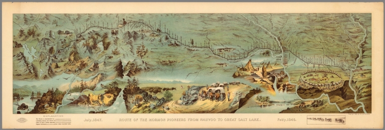


![1 [Explorez avec la Champlain + 70].](https://www.davidrumsey.com/rumsey/Size1/RUMSEY~8~1/205/14404002.jpg)
![2 [Explorez avec la Champlain + 70].](https://www.davidrumsey.com/rumsey/Size2/RUMSEY~8~1/205/14404003.jpg)
![3 [Explorez avec la Champlain + 70].](https://www.davidrumsey.com/rumsey/Size1/RUMSEY~8~1/205/14404004.jpg)
![4 [Explorez avec la Champlain + 70].](https://www.davidrumsey.com/rumsey/Size1/RUMSEY~8~1/205/14404005.jpg)
![5 [Explorez avec la Champlain + 70].](https://www.davidrumsey.com/rumsey/Size1/RUMSEY~8~1/205/14404006.jpg)
![6 [Explorez avec la Champlain + 70].](https://www.davidrumsey.com/rumsey/Size1/RUMSEY~8~1/205/14404007.jpg)
![7 [Explorez avec la Champlain + 70].](https://www.davidrumsey.com/rumsey/Size1/RUMSEY~8~1/205/14404008.jpg)
![8 [Explorez avec la Champlain + 70].](https://www.davidrumsey.com/rumsey/Size1/RUMSEY~8~1/205/14404009.jpg)
![9 [Explorez avec la Champlain + 70].](https://www.davidrumsey.com/rumsey/Size2/RUMSEY~8~1/205/14404010.jpg)
![10 [Explorez avec la Champlain + 70].](https://www.davidrumsey.com/rumsey/Size2/RUMSEY~8~1/205/14404011.jpg)
![11 [Explorez avec la Champlain + 70].](https://www.davidrumsey.com/rumsey/Size1/RUMSEY~8~1/205/14404012.jpg)
![12 [Explorez avec la Champlain + 70].](https://www.davidrumsey.com/rumsey/Size1/RUMSEY~8~1/205/14404013.jpg)
![13 [Explorez avec la Champlain + 70].](https://www.davidrumsey.com/rumsey/Size1/RUMSEY~8~1/205/14404014.jpg)
![14 [Explorez avec la Champlain + 70].](https://www.davidrumsey.com/rumsey/Size2/RUMSEY~8~1/205/14404015.jpg)
![15 [Explorez avec la Champlain + 70].](https://www.davidrumsey.com/rumsey/Size2/RUMSEY~8~1/205/14404016.jpg)
![16 [Explorez avec la Champlain + 70].](https://www.davidrumsey.com/rumsey/Size1/RUMSEY~8~1/205/14404017.jpg)
![17 [Explorez avec la Champlain + 70].](https://www.davidrumsey.com/rumsey/Size2/RUMSEY~8~1/205/14404018.jpg)
![18 [Explorez avec la Champlain + 70].](https://www.davidrumsey.com/rumsey/Size2/RUMSEY~8~1/205/14404019.jpg)
![19 [Explorez avec la Champlain + 70].](https://www.davidrumsey.com/rumsey/Size1/RUMSEY~8~1/205/14404020.jpg)
![20 [Explorez avec la Champlain + 70].](https://www.davidrumsey.com/rumsey/Size2/RUMSEY~8~1/205/14404021.jpg)
![21 [Explorez avec la Champlain + 70].](https://www.davidrumsey.com/rumsey/Size1/RUMSEY~8~1/205/14404022.jpg)
![22 [Explorez avec la Champlain + 70].](https://www.davidrumsey.com/rumsey/Size1/RUMSEY~8~1/205/14404023.jpg)


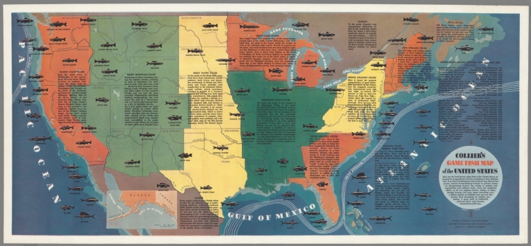


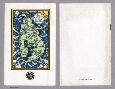


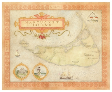
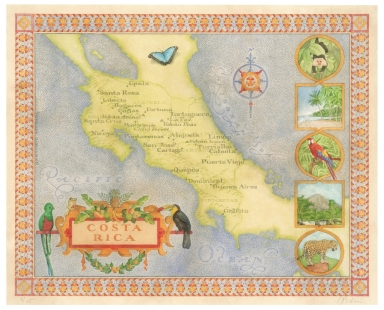

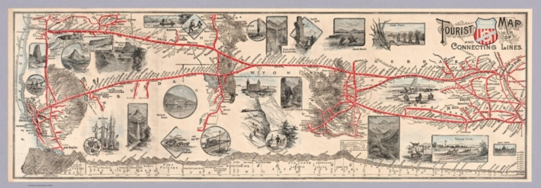
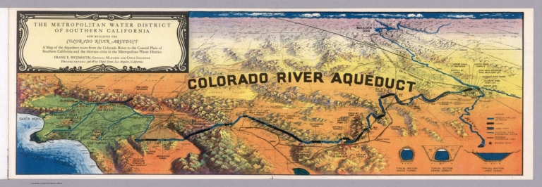


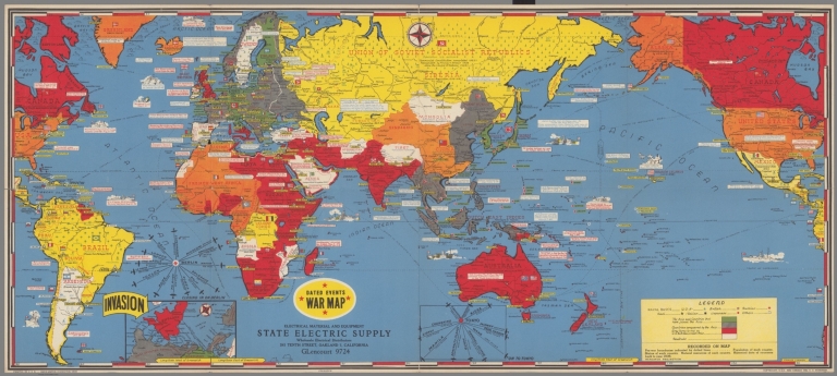


![Covers: PIANTA PANORAMICA DI ROMA [PANORAMA OF ROME]](https://www.davidrumsey.com/rumsey/Size2/RUMSEY~8~1/205/15434003.jpg)
![PIANTA PANORAMICA DI ROMA [PANORAMA OF ROME]](https://www.davidrumsey.com/rumsey/Size2/RUMSEY~8~1/205/15434001.jpg)
![Text: PIANTA PANORAMICA DI ROMA [PANORAMA OF ROME]](https://www.davidrumsey.com/rumsey/Size2/RUMSEY~8~1/205/15434002.jpg)


![[Pictorial Map Cutsheet Advertisement for] Map of the SUrface-Feeding Ducks, Swans and Geese of North America](https://media.davidrumsey.com/MediaManager/srvr?mediafile=/Size3/RUMSEY~8~1/199/15385002.jpg)


![[Hittin' the high spots in Montana].](https://www.davidrumsey.com/rumsey/Size2/RUMSEY~8~1/199/14466002.jpg)


![[Pictorial map of Europe].](https://www.davidrumsey.com/rumsey/Size2/RUMSEY~8~1/199/14469002.jpg)


