موغلا
ظاهر
موغلا | |
|---|---|
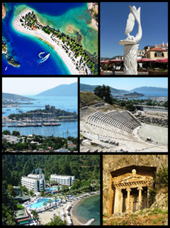
 Top left: Ölüdeniz, Top right: A sculpture in مارماریس, Middle left: Castle of St. Peter in Bodrum, Middle right: Halicarnassus Theatre, Bottom left: Otel Turunç, Bottom right: Tomb of Amyntas. | |
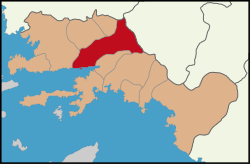
 Location of Muğla district within Muğla Province. | |
| موختصاتلار: 37°13′N 28°22′E / 37.217°N 28.367°Eموختصات: 37°13′N 28°22′E / 37.217°N 28.367°E | |
| اؤلکه | |
| بؤلگه | اژه |
| اوستان | Muğla |
| First cited | In 2nd century BC under the indigenous name of Mobolla during its passage from a Carian federation linked with Taba (تاواس) to Rhodian domination. |
| Lycian or Carian to Menteşe Turkish period (14th century) | Cited as Mobolla with an intermediate form Mogolla attested later. |
| Turkish period (13th century) to the present | Cited as Muğla and a Menteşe urban center, after 1426 center of an عثمانلی ایمپیراتورلوغو vilayet, after 1923 center of the homonymous province under the تورکیه |
| Municipalities | 5 |
| ایداره | |
| • بلدیه باشچیسی | Osman Gürün (CHP) |
| اراضی | |
| • District | ۱٬۶۶۰٫۵۵ km2 (۶۴۱٫۱۴ sq mi) |
| اوجالیق | ۶۶۰ m (۲٬۱۷۰ ft) |
| جمعیت (2012)[۲] | |
| • شهر | ۶۴٬۷۰۶ |
| • District | ۹۹٬۱۵۸ |
| • District density | ۶۰/km2 (۱۵۰/sq mi) |
| ساعات قورشاغی | یوتیسی +3 (EET) |
| • یای (DST) | یوتیسی +3 (EEST) |
| تیلفون کودلاری | (+90) 252 |
| Licence plate | 48 |
| وئب سایت | Muğla Municipality Governorship of Muğla |
موغلا تورکیه جۆمهوریتینین بير بؤیوک شهري دير. بو شهرين ۲۰۰۹ اينجي ايلد ۶۱٬۵۵۰نفر اهاليسي وارمیش[۳][۴].
بیرده باخ
[دَییشدیر]قایناقلار
[دَییشدیر]- ^ Area of regions (including lakes), km². Regional Statistics Database. Turkish Statistical Institute (2002). یوْخلانیلیب2013-03-05.
- ^ Population of province/district centers and towns/villages by districts - 2012. Address Based Population Registration System (ABPRS) Database. Turkish Statistical Institute. یوْخلانیلیب2013-02-27.
- ^ City, town and village population(rapor.tuik.gov.tr[دائمی اولو باغلانتیلی] STATISTICAL INSTITUTE، May 2012|کد دیل(en)
- ^ Turkey: largest cities and towns and statistics of their population(world-gazetteer.com[دائمی اولو باغلانتیلی] Gazetteer،6 May 2012دیل/(en)


