Regions de Nova Zelanda
Aparença
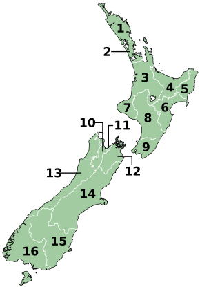
Les regions són la divisió principal del govern local de Nova Zelanda. N'hi ha 16 en total; dotze són governades per un consell electe local i quatre per autoritats territorials.[1]
Llista de regions
[modifica]| Regió | Capital | Àrea (km²) | Població(2)[2] | Codi ISO | 
| |
|---|---|---|---|---|---|---|
| 1 | Northland | Whangarei | 13.941 | 194.600 | NZ-NTL
| |
| 2 | Auckland | Auckland | 16.140 | 1.717.500 | NZ-AUK
| |
| 3 | Waikato | Hamilton | 25.598 | 496.700 | NZ-WKO
| |
| 4 | Bay of Plenty | Tauranga | 12.447 | 337.300 | NZ-BOP
| |
| 5 | Gisborne (1) | Gisborne | 8.351 | 50.700 | NZ-GIS
| |
| 6 | Hawke's Bay | Napier | 14.164 | 178.600 | NZ-HKB
| |
| 7 | Taranaki | Nou Plymouth | 7.273 | 124.600 | NZ-TKI
| |
| 8 | Manawatu-Wanganui | Palmerston North | 22.215 | 254.300 | NZ-MWT
| |
| 9 | Wellington | Wellington | 8.124 | 542.000 | NZ-WGN
| |
| 10 | Tasman (1) | Richmond | 56.400 | 46.500 | NZ-TAS
| |
| 11 | Nelson (1) | Nelson | 445 | 54.600 | NZ-NSN
| |
| 12 | Marlborough (1) | Blenheim | 12.484 | 50.200 | NZ-MBH
| |
| 13 | West Coast | Greymouth | 23.000 | 32.400 | NZ-WTC
| |
| 14 | Canterbury | Christchurch | 45.845 | 645.900 | NZ-CAN
| |
| 15 | Otago | Dunedin | 31.476 | 245.300 | NZ-OTA
| |
| 16 | Southland | Invercargill | 30.753 | 102.600 | NZ-STL
| |
|
(1) Aquestes regions són «Unitary Authorities». | ||||||
Territoris dependents
[modifica]Nova Zelanda també té responsabilitat per afers exteriors dels territoris dependents de les Illes Cook i Niue i administra la dependència de Tokelau.
| Bandera | Escut | Territori | Capital | Àrea | Població | Estatus |
|---|---|---|---|---|---|---|
| Illes Cook | Avarua | 240 km² | 17.434 (2016) | Estat lliure associat a Nova Zelanda | ||

|
Niue | Alofi | 262 km² | 1.612 (2016) | Estat lliure associat a Nova Zelanda | |
| - | Tokelau | - | 10.8 km² | 1.499 (2016) | Territori |
Referències
[modifica]- ↑ Chatham Islands Council Act 1995 Arxivat 2012-07-12 at Archive.is, Parlament de Nova Zelanda, 1995, Statute No 041, Commenced: 1 November 1995, consultat el 4 de febrer de 2008.
- ↑ «Subnational population estimates (RC, SA2), by age and sex, at 30 June 1996-2020 (2020 boundaries)» (en anglès). NZ.Stat. [Consulta: 12 novembre 2020].
