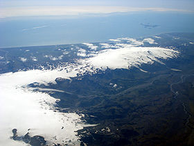
Eyjafjallajökull
Jump to navigation
Jump to search
Català: Eyjafjallajökull és la cinquena glacera més gran d'Islàndia. Es troba al nord de la regió d'Skógar i a l'oest d'una glacera de major mida Mýrdalsjökull. La capa de glaç de la glacera cobreix el volcà (del mateix nom que la glacera).
Deutsch: Eyjafjallajökull ist ein subglazialer Vulkan im Süden von Island. Seine letzten Ausbrüche fanden im Jahr 2010 statt.
English: Eyjafjallajökull is a subglacial volcano in the south of Iceland. The latest eruptions were in 2010.
Français : Eyjafjallajökull est un volcan sous-glaciaire dans le sud de l' Islande. Ses dernières éruptions furent en 2010.
Македонски: Ејафјадлајекидл
Русский: Эйяфьядлайёкюдль — подледникового вулкан на юге Исландии.
Pronounciation
[edit]-
Pronunciation
Maps and satellite pictures
[edit]-
One of the southernmost volcanoes of Iceland
-
Ash plume
-
Earthquakes indicating the second eruption series under Eyjafjallajökull in 2010 (source:IMO)
-
Eyjafjallajökull is part of the EVZ (East Volcanic Zone)
Approaching Eyjafjallajökull
[edit]Aerial views
[edit]-
To the right of Mýrdalsjökull/Katla
-
The aircraft here is over Mýrdalsjökull, Eyjafjallajökull in front and behind it to the right, the volcanic archipelagos of the Westman Islands (Vestmannaeyjar)
-
Þórsmörk with the glacial river Krossá in the foreground
From the archipelagos of Vestmannaeyjar
[edit]-
With a Danish inspection vessel in the foreground
From Mýrdalsjökull
[edit]Views of the glacier and dormant volcano
[edit]Volcanic eruptions in 2010
[edit]Fimmvörðuháls eruptions in March - April 2010
[edit]The first series of eruptions started in March 2010 and went on for about 3 weeks. The effusive eruptions on the mountain pass Fimmvörðuháls originated in volcanic fissures which are part of the Eyjafjallajökull volcanic system.
-
2010-04-01: aerial view of the vents (NASA)
-
2010-03-25: The first pyroclastic cone and the steam cloud from the lava flow in Hrunagil. Seen from Fauskheiði.
-
2010-03-25: eruptions begin in the Fimmvörðuháls pass area
-
2010-03-27: Fimmvörðuháls in the twilight
-
2010-03-29: The first fissure that opened on Fimmvörðuháls, as seen from Austurgígar.
-
2010-04-02: steaming second fissure on Fimmvörðuháls
-
2010-04-03: on Fimmvörðuháls
-
2010-04-03: on Fimmvörðuháls
-
Aerial views of the Fimmvörðuháls eruptions
Eyjafjallajökull subglacial eruptions in April - June 2010
[edit]The second series of eruptions started subglacially under Eyjafjallajökull himself the 14th of April 2010 and went on til the end of June. They were explosive, producing very fine grained tephra of a trachyandesite type which caused important disruptions of European airtravel during the next weeks and months.
-
Cross cutting through the neighbouring Eyjafjöll and Katla volcanic systems with indication of the eruption locations
-
Scheme of a subglacial eruption. 1. Water vapor cloud, 2. Lake, 3. Ice, 4. Layers of lava and ash, 5. Stratum, 6. Pillow lava, 7. Magma conduit, 8. Magma chamber, 9. Dike
-
2010-04-17: The ash plume from the second eruption in Eyjafjallajökull seen from Fljótshlíð 1
-
2010-04-17: ash plume from the erupting Eyjafjallajökull 2
-
2010-04-17: ash plume from the erupting Eyjafjallajökull 3
-
2010-04-20: The second eruption in Eyjafjallajökull seen from Fljótshlíð at night.
-
2010-04-15: The craters at beginning of second eruption series
-
2010-05-01: ash plume from the erupting Eyjafjallajökull seen from the Falcon scientific airplane
Air travel disruptions in Europe
[edit]Satellite images of ash distribution
[edit]-
Ash plume on April 17, 2010
-
April 17, 2010
-
Ash plume over the North Atlantic, April 15, 2010
-
May 10, 2010
-
Volcanic ash over Europe on April 16, 2010
Situation at some airports
[edit]-
At Charles de Gaulle airport in Paris
-
At Leed Bradford Airport
Developments re. airtravel between 17th and 20th April 2010
[edit]-
April 18, 2010
-
April 19, 2010
-
April 20, 2010
Before and after
[edit]Gígjökull
[edit]-
Eyjafjallajökull's outlet glacier Gígjökull in 2003 with the glacial lake in front
-
Outlet glacier in 2004
-
Outlet glacier and lake in 2007 (before the eruptions)
-
Gígjökull during the eruptions in May 2010
-
The same outlet glacier in 2011 after the eruptions
-
Also in 2011: The lake has not only disappeared, but has been replaced by a hill of volcanic ash and debris...
-
... placed there during jökulhlaup and eruption of lava flows, which trickled beneath the glacier down to the valley
Þorvaldseyri
[edit]From the nearby farmstead of Þorvaldseyri, changes in Eyjafjallajökull can be seen very clearly.
-
In the year 2008
-
During the second series of eruptions in 2010
Landscape recovery after the eruptions
[edit]Farmsteads in the vicinity
[edit]-
South coast of Iceland in 2012: Green again
-
Eyjafajallajökull in 2012: White again
Þórsmörk
[edit]-
Þórsmörk in 2010 and 2011
-
Seen from Þórsmörk in 2013


