
Evaluating the Performance of Hydrological Models for Flood Discharge Simulation in the Wangchu River Basin, Bhutan


Abstract
:1. Introduction
2. Materials and Methods
2.1. Study Area Description
2.2. Research Flow
2.3. Data Preparation
2.4. Description of the Selected Models and Parameter Setting
2.4.1. IFAS Model
2.4.2. Description and Processing of the HEC-HMS Model
- Loss model
- 2.
- Transform model
- 3.
- Routing model
2.4.3. Description of GEOGloWS MODEL
2.5. Model Performance Evaluation Metrics
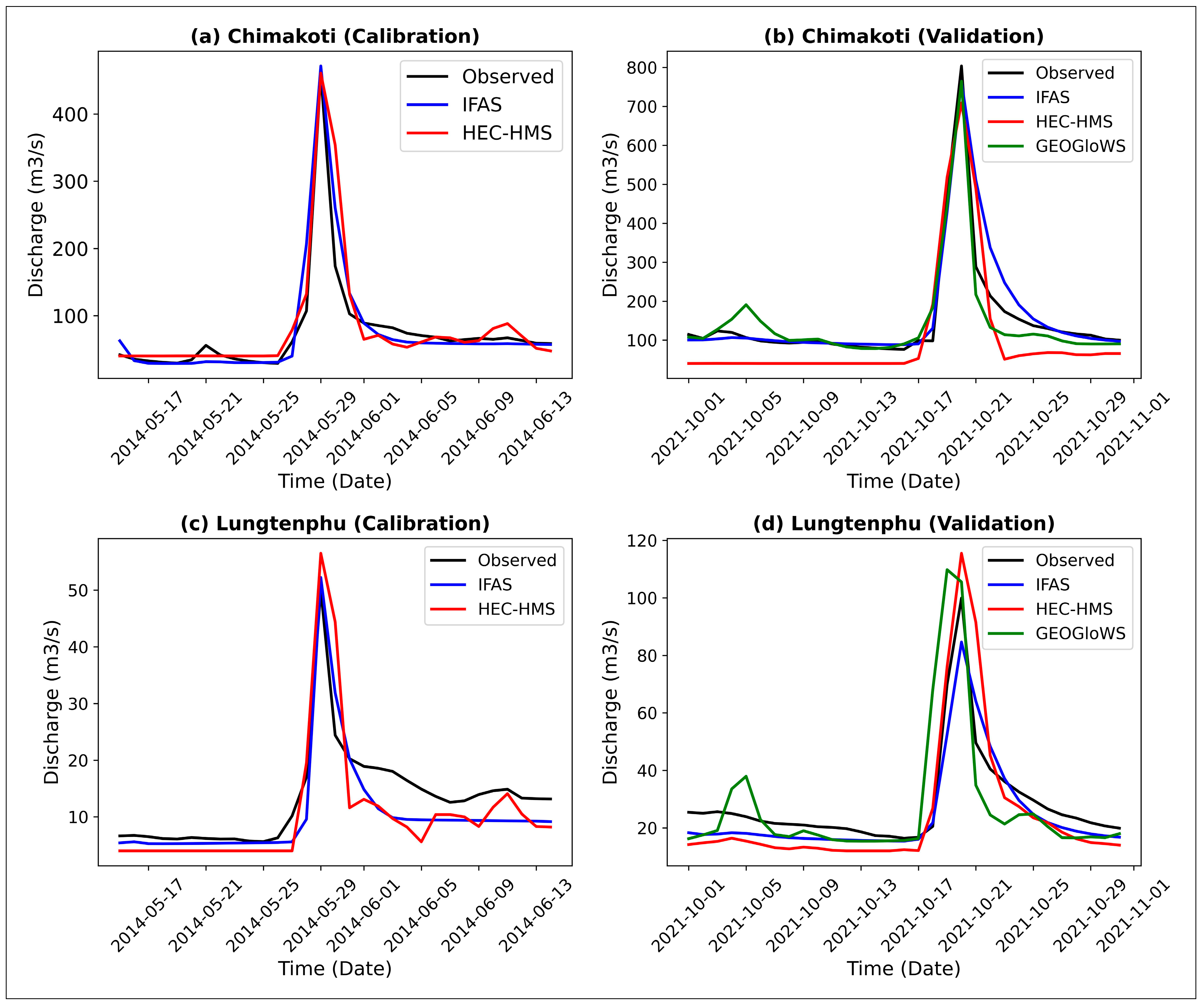
3. Results
3.1. Results of Model Performance
3.1.1. IFAS Model
3.1.2. HEC-HMS Model
3.1.3. GEOGloWS Model
3.2. Performance Based on Basin Size
4. Discussion
5. Conclusions
Supplementary Materials
Author Contributions
Funding
Data Availability Statement
Acknowledgments
Conflicts of Interest
References
- Winsemius, H.C.; Aerts, J.C.; Van Beek, L.P.; Bierkens, M.F.; Bouwman, A.; Jongman, B.; Ward, P.J. Global drivers of future river flood risk. Nat. Clim. Chang. 2016, 6, 381–385. [Google Scholar] [CrossRef]
- Jongman, B. Effective adaptation to rising flood risk. Nat. Commun. 2018, 9, 1986. [Google Scholar] [CrossRef]
- IPCC (International Panel on Climate Change). The Physical Science Basis. In Contribution of Working Group I to the Sixth Assess ment Report of the Intergovernmental Panel on Climate Change; Masson-Delmotte, V.P., Zhai, A., Pirani, S.L., Connors, C., Péan, S., Berger, N., Caud, Y., Chen, L., Goldfarb, M.I., Gomis, M., Eds.; Cambridge University Press: Cambridge, UK, 2021. [Google Scholar]
- Chow, M.F.; Jamil, M.M. Review of development and applications of Integrated Flood Analysis System (IFAS) for flood forecasting in insufficiently-gauged catchments. J. Eng. Appl. Sci. 2017, 12, 9210–9215. [Google Scholar]
- Shrestha, S.; Bae, D.H.; Hok, P.; Ghimire, S.; Pokhrel, Y. Future hydrology and hydrological extremes under climate change in Asian river basins. Sci. Rep. 2021, 11, 17089. [Google Scholar] [CrossRef]
- Nagamani, K.; Mishra, A.K.; Meer, M.S.; Das, J. Understanding flash flooding in the Himalayan Region: A case study. Sci. Rep. 2024, 14, 7060. [Google Scholar] [CrossRef] [PubMed]
- Mahanta, C.; Mahagaonkar, A.; Choudhury, R. Climate change and hydrological perspective of Bhutan. In Groundwater of South Asia; Springer: Singapore, 2018; pp. 569–582. [Google Scholar]
- Tempa, K. District flood vulnerability assessment using analytic hierarchy process (AHP) with historical flood events in Bhutan. PLoS ONE 2022, 17, e0270467. [Google Scholar] [CrossRef]
- NCHM (National Centre for Hydrology and Meteorology). Compendium of Climate and Hydrological Extremes in Bhutan Since 1968 from Kuensel; NCHM (National Centre for Hydrology and Meteorology): Thimphu, Bhutan, 2020. [Google Scholar]
- NCHM (National Centre for Hydrology and Meteorology). Report on the Analysis of Historical Climate and Climate Projection for Bhutan; NCHM (National Centre for Hydrology and Meteorology): Thimphu, Bhutan, 2019. [Google Scholar]
- Zam, P.; Shrestha, S.; Budhathoki, A. Assessment of climate change impact on hydrology of a transboundary river of Bhutan and India. J. Water Clim. Chang. 2021, 12, 3224–3239. [Google Scholar] [CrossRef]
- Syldon, P.; Shrestha, B.B.; Miyamoto, M.; Tamakawa, K.; Nakamura, S. Assessing the impact of climate change on flood inundation and agriculture in the Himalayan Mountainous Region of Bhutan. J. Hydrol. 2024, 52, 101687. [Google Scholar] [CrossRef]
- Paul, P.K.; Zhang, Y.; Ma, N.; Mishra, A.; Panigrahy, N.; Singh, R. Selecting hydrological models for developing countries: Perspective of global, continental, and country scale models over catchment scale models. J. Hydrol. 2021, 600, 126561. [Google Scholar] [CrossRef]
- Sahu, M.K.; Shwetha, H.R.; Dwarakish, G.S. State-of-the-art hydrological models and application of the HEC-HMS model: A review. Model. Earth Syst. Environ. 2023, 9, 3029–3051. [Google Scholar] [CrossRef]
- Lee, A.F.; Kawata, Y. Assessing the Influence of Cell Size on Flood Modelling by the PWRI-DH Model Using IFAS. J. Disaster Res. 2019, 14, 188–197. [Google Scholar] [CrossRef]
- Lee, A.F.; Saenz, A.V.; Kawata, Y. On the calibration of the parameters governing the PWRI distributed hydrological model for flood prediction. J. Saf. Sci. Resil. 2020, 1, 80–90. [Google Scholar] [CrossRef]
- Thielen, J.; Bartholmes, J.; Ramos, M.H.; De Roo, A. The European flood alert system—Part 1: Concept and development. Hydrol. Earth Syst. Sci. 2009, 13, 125–140. [Google Scholar] [CrossRef]
- Lozano, J.S.; Bustamante, G.R.; Hales, R.C.; Nelson, E.J.; Williams, G.P.; Ames, D.P.; Jones, N.L. A streamflow bias correction and performance evaluation web application for GEOGloWS ECMWF streamflow services. Hydrology 2021, 8, 71. [Google Scholar] [CrossRef]
- Fakhruddin, S.H.M. Development of flood forecasting system for the wangchhu river Basin in Bhutan. J. Geogr. Geol. 2017, 7, 70. [Google Scholar] [CrossRef]
- Tsering, K.; Shrestha, M.; Shakya, K.; Bajracharya, B.; Matin, M.; Lozano, J.L.S.; Bhuyan, M.A. Verification of two hydrological models for real-time flood forecasting in the Hindu Kush Himalaya (HKH) region. Nat. Hazards 2022, 110, 1821–1845. [Google Scholar] [CrossRef]
- Shahzad, A.; Gabriel, H.F.; Haider, S.; Mubeen, A.; Siddiqui, M.J. Development of a flood forecasting system using IFAS: A case study of scarcely gauged Jhelum and Chenab River basins. Arab. J. Geosci. 2018, 11, 383. [Google Scholar] [CrossRef]
- Umer, M.; Gabriel, H.F.; Haider, S.; Nusrat, A.; Shahid, M.; Umer, M. Application of precipitation products for flood modeling of transboundary river basin: A case study of Jhelum Basin. Theor. Appl. Climatol. 2021, 143, 989–1004. [Google Scholar] [CrossRef]
- Chen, Y.C.; Gao, J.J.; Bin, Z.H.; Qian, J.Z.; Pei, R.L.; Zhu, H. Application study of IFAS and LSTM models on runoff simulation and flood prediction in the Tokachi River basin. J. Hydroinformatics 2021, 23, 1098–1111. [Google Scholar] [CrossRef]
- Dinh, D.C.; Nguyen, T.T.T.; Tong, N.T.; Van, P.T.; Vu, V.M. Research on the applicability of IFAS model in flood analysis (Pilot at Bang Giang River basin in Cao Bang Province). In Proceedings of the 28th Conference on Environmental Informatics-Informatics for Environmental Protection, Sustainable Development and Risk Management, Oldenburg, Germany, 10–12 September 2014; pp. 317–324. [Google Scholar]
- Hafiz, I.; Sidek, L.M.; Basri, H.; Fukami, K.; Hanapi, M.N.; Livia, L.; Jaafar, A.S. Integrated flood analysis system (IFAS) for Kelantan river basin. In Proceedings of the 2014 IEEE 2nd International Symposium on Telecommunication Technologies (ISTT) 2014, Langkawi, Malaysia, 24–26 November 2014; pp. 159–162. [Google Scholar]
- Chow, M.F. An Overview of the Integrated Flood Analysis System (IFAS) Studies in Insufficiently Gauged Catchments: Approaches, Challenges, and Prospects. In Integrated Research on Disaster Risks: Contributions from the IRDR Young Scientists Programme; Springer: Cham, Switzerland, 2021; pp. 71–85. [Google Scholar]
- Dahal, D.; Kumar, P.; Chhetri, R.; Talchabhadel, R.; Rai, C.M. River discharge estimation in the Punatshangchu River Basin, Bhutan using an integrated flood analysis system. Int. J. Hydrol. Sci. Technol. 2024, 17, 117–133. [Google Scholar] [CrossRef]
- NWHS (Ministry of Works and Human Settlement). Flood assessment for Trongsa Dzongkhag. In Flood Engineering and Management Division, Department of Engineering Services; NWHS (Ministry of Works and Human Settlement): Thimphu, Bhutan, 2020. [Google Scholar]
- Tassew, B.G.; Belete, M.A.; Miegel, K. Application of HEC-HMS model for flow simulation in the Lake Tana basin: The case of Gilgel Abay catchment, upper Blue Nile basin, Ethiopia. Hydrology 2019, 6, 21. [Google Scholar] [CrossRef]
- Shakarneh, M.O.A.; Khan, A.J.; Mahmood, Q.; Khan, R.; Shahzad, M.; Tahir, A.A. Modeling of rainfall–runoff events using HEC-HMS model in southern catchments of Jerusalem Desert-Palestine. Arab. J. Geosci. 2022, 15, 127. [Google Scholar] [CrossRef]
- Verma, R.; Sharif, M.; Husain, A. Application of HEC-HMS for hydrological modeling of upper Sabarmati River Basin, Gujarat, India. Model. Earth Syst. Environ. 2022, 8, 5585–5593. [Google Scholar] [CrossRef]
- Dorji, L.; Sarkar, R.; Lhachey, U.; Sharma, V.; Tshewang; Dikshit, A.; Kurar, R. An Evaluation of Hydrological Modeling Using SCS-CN Method in Ungauged Om Chhu River Basin of Phuentsholing, Bhutan. In An Interdisciplinary Approach for Disaster Resilience and Sustainability; Springer: Singapore, 2020; pp. 111–121. [Google Scholar]
- Ashby, K.R.; Hales, R.C.; Nelson, J.; Ames, D.P.; Williams, G.P. Hydroviewer: A web application to localize global hydrologic forecasts. Open Water J. 2021, 7, 9. [Google Scholar]
- Hales, R.C.; Nelson, E.J.; Souffront, M.; Gutierrez, A.L.; Prudhomme, C.; Kopp, S.; Ames, D.P.; Williams, G.P.; Jones, N.L. Advancing global hydrologic modeling with the GEOGloWS ECMWF streamflow service. J. Flood Risk Manag. 2022, 18, e12859. [Google Scholar] [CrossRef]
- Souffront Alcantara, M.A.; Nelson, E.J.; Shakya, K.; Edwards, C.; Roberts, W.; Krewson, C.; Ames, D.P.; Jones, N.L.; Gutierrez, A. Hydrologic modeling as a service (HMaaS): A new approach to address hydroinformatic challenges in developing countries. Front. Environ. Sci. 2019, 7, 158. [Google Scholar] [CrossRef]
- Xue, X.; Hong, Y.; Limaye, A.S.; Gourley, J.J.; Huffman, G.J.; Khan, S.I.; Chen, S. Statistical and hydrological evaluation of TRMM-based Multi-satellite Precipitation Analysis over the Wangchu Basin of Bhutan: Are the latest satellite precipitation products 3B42V7 ready for use in ungauged basins? J. Hydrol. 2013, 499, 91–99. [Google Scholar] [CrossRef]
- Nash, J.E.; Sutcliffe, J.V. River flow forecasting through conceptual models part I—A discussion of principles. J. Hydrol. 1970, 10, 282–290. [Google Scholar] [CrossRef]
- Moriasi, D.N.; Arnold, J.G.; Van Liew, M.W.; Bingner, R.L.; Harmel, R.D.; Veith, T.L. Model evaluation guidelines for systematic quantification of accuracy in watershed simulations. Trans. ASABE 2007, 50, 885–900. [Google Scholar] [CrossRef]
- Lozano, J.S.; Lesmes, D.R.; Bustamante, E.R.; Hales, R.C.; Nelson, E.J.; Williams, G.P.; Ames, D.P.; Jones, N.L.; Gutierrez, A.L.; Almeida, C.C. Historical simulation performance evaluation and monthly flow duration curve quantile-mapping (MFDC-QM) of the GEOGLOWS ECMWF streamflow hydrologic model. Environ. Model. Softw. 2025, 183, 106235. [Google Scholar] [CrossRef]
- Sugiura, T.; Fukami, K.; Inomata, H. Development of integrated flood analysis system (IFAS) and its applications. In Proceedings of the World Environmental and Water Resources Congress 2008, Honolulu, HI, USA, 12–16 May 2008; pp. 1–10. [Google Scholar]
- ICHARM (International Centre for Water Hazard and Risk Management). IFAS ver.2.0 Technical Manual; International Centre for Water Hazards and Risk Management, Public Works Research Institute: Ibaraki-ken, Japan, 2014. [Google Scholar]
- Nusrat, A.; Gabriel, H.F.; Haider, S.; Siddique, M. Sensitivity analysis and optimization of land use/cover and aquifer parameters for improved calibration of hydrological model. Mehran Univ. Res. J. Eng. Technol. 2022, 41, 21–34. [Google Scholar] [CrossRef]
- Ben Khélifa, W.; Mosbahi, M. Modeling of rainfall-runoff process using HEC-HMS model for an urban ungauged watershed in Tunisia. Model. Earth Syst. Environ. 2021, 8, 1749–1758. [Google Scholar] [CrossRef]
- Ranjan, S.; Singh, V. HEC-HMS based rainfall-runoff model for Punpun river basin. Water Pract. Technol. 2022, 17, 986–1001. [Google Scholar] [CrossRef]
- Ren, D.F.; Cao, A.H. Precipitation-runoff simulation in Xiushui river basin using HEC-HMS hydrological model. Model. Earth Syst. Environ. 2023, 9, 2845–2856. [Google Scholar] [CrossRef]
- Cronshey, R. Urban Hydrology for Small Watersheds; No. 55; U.S. Department of Agriculture, Soil Conservation Service, Engineering Division: Washington, DC, USA, 1986. [Google Scholar]
- Guduru, J.U.; Jilo, N.B.; Rabba, Z.A.; Namara, W.G. Rainfall-runoff modeling using HEC-HMS model for Meki River watershed, rift valley basin, Ethiopia. J. Afr. Earth Sci. 2023, 197, 104743. [Google Scholar] [CrossRef]
- Gutenson, J.L.; Sparrow, K.H.; Brown, S.W.; Wahl, M.D.; Gordon, K.B. Case study of continental-scale hydrologic modeling’s ability to predict daily streamflow percentiles for regulatory application. JAWRA J. Am. Water Resour. Assoc. 2024, 60, 461–479. [Google Scholar] [CrossRef]
- Farmer, W.H.; Over, T.M.; Kiang, J.E. Bias correction of simulated historical daily streamflow at ungauged locations by using independently estimated flow duration curves. Hydrol. Earth Syst. Sci. 2018, 22, 5741–5758. [Google Scholar] [CrossRef]
- Rizwan, M.; Li, X.; Chen, Y.; Anjum, L.; Hamid, S.; Yamin, M.; Mehmood, Q. Simulating future flood risks under climate change in the source region of the Indus River. J. Flood Risk Manag. 2023, 16, e12857. [Google Scholar] [CrossRef]
- Riaz, M.; Aziz, A.; Hussain, S. Flood forecasting of an ungauged trans-boundary Chenab River basin using distributed hydrological model Integrated Flood Analysis System (IFAS). Pak. J. Meteorol. 2017, 13, 51–62. [Google Scholar]
- Aziz, A.; Tanaka, S. Regional parameterization and applicability of Integrated Flood Analysis System (IFAS) for flood forecasting of upper-middle Indus River. Pak. J. Meteorol. 2011, 8, 21–38. [Google Scholar]
- Chow, M.F.; Jamil, M.M.; Ros, F.C.; Yuzir, M.A.M.; Hossain, M.S. Evaluation of parameter regionalization methods for flood simulations in Kelantan river basin. Int. J. Innov. Technol. Explor. Eng. 2019, 8, 313–318. [Google Scholar]
- Gunathilake, M.B.; Panditharathne, P.; Gunathilake, A.S.; Warakagoda, N. Application of a HEC-HMS model on event-based simulations in a tropical watershed. Eng. Appl. Sci. Res. 2020, 47, 349–360.49. [Google Scholar]


| Station Name | Station ID | Latitude | Longitude | Elevation (m) |
|---|---|---|---|---|
| Meteorological stations | ||||
| Semtokha | 12700046 | 27.44 | 89.42 | 2504 |
| Begana | - | 27.57 | 89.64 | 2520 |
| Paro | 12510046 | 27.38 | 89.68 | 2402 |
| Drugyel Dzong | 12580046 | 27.50 | 89.33 | 2467 |
| Chapchu | 12390046 | 27.07 | 89.55 | 2620 |
| Haa | 12510046 | 27.39 | 89.28 | 2726 |
| Hydrological stations | ||||
| Lungtenphu | 12800045 | 27.45 | 89.66 | 2260 |
| Chimakoti | 12350073 | 27.11 | 89.53 | 2678 |
| Dataset | Elevation | Land Use | Soil |
|---|---|---|---|
| Product name | GTOPO30 | Land use land cover | Soil water-holding capacity |
| Resolution | 30 arc second (1 km) | 30 arc second (1 km mesh) | 1 degree |
| Format | Raster (Tiles) | Raster (bil) | bil |
| Coordinate | WGS84 | WGS84 | 90° N and 180° W |
| Coverage | World | World | World |
| Data source | https://earthexplorer.usgs.gov/ (accessed on 13 May 2023) | https://earthexplorer.usgs.gov/ (accessed on 15 May 2023) | https://www.fao.org/soils-portal/data-hub/soil-maps (accessed on 15 May 2023) |
| Model | Method | Parameters | Functions |
|---|---|---|---|
| Loss | SCS-CN | Initial abstraction (mm) | The initial amount of rainfall lost due to surface storage, interception, and infiltration. |
| Curve number | It reflects the basin’s runoff potential based on land use, soil type, and moisture conditions. | ||
| Imperviousness (%) | The percentage of the basin area that is impervious, which contributes to surface runoff without infiltration. | ||
| Transform | SCS-UN | Lag time (min) | The time delay between the peak rainfall and peak runoff. It affects the shape of the hydrograph. |
| Routing | Muskingum | Travel time | The time it takes for water to move through a stream. It affects how quickly runoff reaches the outlet. |
| Attenuation flood wave | It accounts for storage effects in the channel, leading to a flattened hydrograph and reduced peak discharge. |
| Sub-Basins | Area (km2) | Length (km) | Centroidal Flow Path (km) | Slope (Degree) | Drainage Density (km/km2) | Curve Numbers | Lag Time (hour) |
|---|---|---|---|---|---|---|---|
| Sub-basin1 | 418 | 34 | 12 | 60.03 | 0.066 | 83 | 2.55 |
| Sub-basin2 | 617 | 48 | 19 | 57.65 | 0.094 | 78 | 3.54 |
| Sub-basin3 | 432 | 42 | 21 | 57.65 | 0.089 | 86 | 3.67 |
| Sub-basin4 | 216 | 26 | 8 | 50.48 | 0.093 | 73 | 2.04 |
| Sub-basin5 | 533 | 39 | 15 | 50.96 | 0.088 | 65 | 3.84 |
| Sub-basin6 | 221 | 30 | 12 | 47.91 | 0.099 | 69 | 2.36 |
| Sub-basin7 | 544 | 54 | 23 | 54.39 | 0.084 | 78 | 4.18 |
| Sub-basin8 | 227 | 34 | 14 | 52.73 | 0.118 | 60 | 3.16 |
| Sub-basin9 | 148 | 20 | 6 | 52.21 | 0.109 | 68 | 2.16 |
| Sub-basin10 | 160 | 34 | 15 | 56.99 | 0.088 | 72 | 2.38 |
| Tank Model | Parameters | Notations | Units | Default Parameter | Calibrated Parameters |
|---|---|---|---|---|---|
| Surface tank | Final infiltration capacity | SKF | cm/s | 0.0005 | 0.005 |
| 0.00002 | 0.002 | ||||
| 0.00001 | 0.001 | ||||
| 0.000001 | 0.0001 | ||||
| 0.00001 | 0.0001 | ||||
| Surface roughness coefficient | SNF | m−1/3/s | 0.70 | 1.50 | |
| 2.00 | 2.00 | ||||
| 2.00 | 2.00 | ||||
| 0.10 | 1.00 | ||||
| 2.00 | 2.00 | ||||
| Aquifer tank | Runoff coefficient of unconfined aquifer | AUD | (1/mm/day)1/2 | 0.10 | 0.02 |
| Runoff coefficient of confined aquifer | AGD | 1/day | 0.003 | 0.001 | |
| River course tank | Coefficient for cross-section shape | RLCOF | Non-dimensional | 1.4 | 1.4 |
| Parameters | Calibrated Values |
|---|---|
| 0.2 |
| 1.9 |
| 7 |
| 0.1 |
Disclaimer/Publisher’s Note: The statements, opinions and data contained in all publications are solely those of the individual author(s) and contributor(s) and not of MDPI and/or the editor(s). MDPI and/or the editor(s) disclaim responsibility for any injury to people or property resulting from any ideas, methods, instructions or products referred to in the content. |
© 2025 by the authors. Licensee MDPI, Basel, Switzerland. This article is an open access article distributed under the terms and conditions of the Creative Commons Attribution (CC BY) license (https://creativecommons.org/licenses/by/4.0/).
Share and Cite
Dahal, D.; Kojima, T. Evaluating the Performance of Hydrological Models for Flood Discharge Simulation in the Wangchu River Basin, Bhutan. Hydrology 2025, 12, 51. https://doi.org/10.3390/hydrology12030051
Dahal D, Kojima T. Evaluating the Performance of Hydrological Models for Flood Discharge Simulation in the Wangchu River Basin, Bhutan. Hydrology. 2025; 12(3):51. https://doi.org/10.3390/hydrology12030051
Chicago/Turabian StyleDahal, Damudar, and Toshiharu Kojima. 2025. "Evaluating the Performance of Hydrological Models for Flood Discharge Simulation in the Wangchu River Basin, Bhutan" Hydrology 12, no. 3: 51. https://doi.org/10.3390/hydrology12030051
APA StyleDahal, D., & Kojima, T. (2025). Evaluating the Performance of Hydrological Models for Flood Discharge Simulation in the Wangchu River Basin, Bhutan. Hydrology, 12(3), 51. https://doi.org/10.3390/hydrology12030051