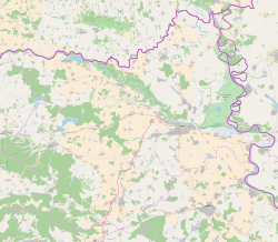
Kneževi Vinogradi (Hungarian: Hercegszöllős; Serbian Cyrillic: Кнежеви Виногради) is a village and municipality in Croatia. It is situated in the Osijek-Baranja County, on the southern slopes of Bansko Brdo, 11 km southeast of Beli Manastir. It lies at an altitude of 103 m. Chief occupations of villagers include farming, viticulture, livestock breeding and dairy industry. At the time of 2011 census, Kneževi Vinogradi was the only municipality in Croatia with a relative majority of Hungarians of Croatia.
Kneževi Vinogradi
| |
|---|---|
| Municipality of Kneževi Vinogradi Općina Kneževi Vinogradi | |
| Coordinates: 45°45′1″N 18°43′59″E / 45.75028°N 18.73306°E | |
| Country | |
| Region | Baranya (Podunavlje) |
| County | |
| Government | |
| • Municipal mayor | Deneš Šoja |
| Area | |
| 249.6 km2 (96.4 sq mi) | |
| • Urban | 144.2 km2 (55.7 sq mi) |
| Population (2021)[4] | |
| 3,357 | |
| • Density | 13/km2 (35/sq mi) |
| • Urban | 1,332 |
| • Urban density | 9.2/km2 (24/sq mi) |
| Time zone | UTC+1 (CET) |
| • Summer (DST) | UTC+2 (CEST) |
| Postal codes | 31309 Kneževi Vinogradi |
| Area code | 031 |
| Website | knezevi-vinogradi |
In Roman times, the Donatium colony was located here, so Suljoš, as people call Kneževe Vinograde, is one of the oldest places in Baranja.[5]
Name
editThe name of the village derived from Croatian words "knez" ("prince" in English) and "vinograd" ("vineyard" in English), hence the meaning of the name is "the prince's vineyards". The name of the village in Serbo-Croatian is plural.
In other languages, the village in German is known as Weingärten or Weingärten i.d.Braunau, in Hungarian as Hercegszöllős (earlier Herczeg-Szöllős) and in Serbian as Kneževi Vinogradi (Кнежеви Виногради).[6]
Geography
editThe municipality of Kneževi Vinogradi include following settlements:
History
editDuring the Croatian War of Independence the village became a part of the self proclaimed SAO Eastern Slavonia, Baranja and Western Syrmia. At the time of Operation Medak Pocket local population led by women organized resistance to mobilization of their husbands who were to be sent to Knin, capital of the self-proclaimed Republic of Serbian Krajina.[7] The group shouted paroles such as "we do not give our husbands", "we don't want them to defend Knin", "who will defend Baranja?"...[7] In the afternoon on the day of the protest, local residents erected barricades at the entrance to the village to prevent the mobilization.[7]
Features
editKneževi Vinogradi is underdeveloped municipality which is statistically classified as the First Category Area of Special State Concern by the Government of Croatia.[8]
Demographics
editMunicipality
editEthnic groups (2001)
According to the 2001 census, there are 5,186 inhabitants in the municipality, including:[9]
- Hungarians (40.9%)
- Croats (34.34%)
- Serbs (18.43%)
- Germans (1.95%)
- others (including Romani, Albanians, Macedonians, Slovenes, etc.).
Village
editAccording to the 2001 census, there are 1,715 inhabitants in the Kneževi Vinogradi village, including:
- Croats = 844
- Serbs = 535
- Hungarians = 275
- others = 61
Politics
editMinority councils
editDirectly elected minority councils and representatives are tasked with consulting the local or regional authorities, advocating for minority rights and interests, integration into public life and participation in the management of local affairs.[10] At the 2023 Croatian national minorities councils and representatives elections Hungarians and Serbs of Croatia each fulfilled legal requirements to elect 10 members municipal minority councils of the Kneževi Vinogradi Municipality.[11]
See also
editReferences
edit- ^ Government of Croatia (October 2013). "Peto izvješće Republike Hrvatske o primjeni Europske povelje o regionalnim ili manjinskim jezicima" (PDF) (in Croatian). Council of Europe. p. 36. Retrieved 30 November 2016.
- ^ "Statut Općine Kneževi Vinogradi" (PDF) (in Croatian). Article 15. Retrieved 7 August 2015.
- ^ Register of spatial units of the State Geodetic Administration of the Republic of Croatia. Wikidata Q119585703.
- ^ "Population by Age and Sex, by Settlements" (xlsx). Census of Population, Households and Dwellings in 2021. Zagreb: Croatian Bureau of Statistics. 2022.
- ^ "O Baranji". Visit Baranja (in Croatian). Retrieved 2023-04-10.
- ^ "Registar Geografskih Imena Nacionalnih Manjina Republike Hrvatske" (PDF). Archived from the original (PDF) on 2013-10-29. Retrieved 2013-03-08.
- ^ a b c Nikolić, Kosta (2023). Krajina: 1991.–1995 (in Serbo-Croatian). Zaprešić & Zagreb: Fraktura & Serb National Council. p. 191. ISBN 978-953-358-654-0.
- ^ Lovrinčević, Željko; Davor, Mikulić; Budak, Jelena (June 2004). "AREAS OF SPECIAL STATE CONCERN IN CROATIA- REGIONAL DEVELOPMENT DIFFERENCES AND THE DEMOGRAPHIC AND EDUCATIONAL CHARACTERISTICS". Ekonomski pregled, Vol.55 No.5-6. Archived from the original on 18 August 2018. Retrieved 25 August 2018.
- ^ "SAS Output". Dzs.hr. Retrieved 2012-06-27.
- ^ "Manjinski izbori prve nedjelje u svibnju, kreću i edukacije". T-portal. 13 March 2023. Retrieved 2 May 2023.
- ^ "Informacija o konačnim rezultatima izbora članova vijeća i izbora predstavnika nacionalnih manjina 2023. XIV. OSJEČKO-BARANJSKA ŽUPANIJA" (PDF) (in Croatian). Državno izborno povjerenstvo Republike Hrvatske. 2023. p. 30. Retrieved 3 June 2023.


