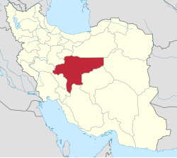
Nain County (Persian: شهرستان نائین) is in Isfahan province, Iran. Its capital is the city of Nain.[3]
Nain County
Persian: شهرستان نائین | |
|---|---|
 Location of Nain County in Isfahan province (right, green) | |
 Location of Isfahan province in Iran | |
| Coordinates: 33°22′N 53°29′E / 33.367°N 53.483°E[1] | |
| Country | |
| Province | Isfahan |
| Capital | Nain |
| Districts | Central, Anarak |
| Population (2016)[2] | |
• Total | 39,261 |
| Time zone | UTC+3:30 (IRST) |
History
editAfter the 2006 National Census, Khur and Biabanak District was separated from the county in the establishment of Khur and Biabanak County.[4] The village of Bafran was elevated to the status of a city.[5]
Demographics
editPopulation
editAt the time of the 2006 census, the county's population was 54,298 in 15,919 households.[6] The following census in 2011 counted 38,077 people in 12,123 households.[7] The 2016 census measured the population of the county as 39,261 in 13,378 households.[2]
Administrative divisions
editNain County's population history and administrative structure over three consecutive censuses are shown in the following table.
| Administrative Divisions | 2006[6] | 2011[7] | 2016[2] |
|---|---|---|---|
| Central District | 33,906 | 34,177 | 35,440 |
| Bafran RD | 3,603 | 1,782 | 1,483 |
| Baharestan RD | 1,603 | 1,444 | 1,302 |
| Kuhestan RD | 1,735 | 992 | 996 |
| Lay Siyah RD | 2,541 | 2,553 | 2,302 |
| Bafran (city) | 2,027 | 1,978 | |
| Nain (city) | 24,424 | 25,379 | 27,379 |
| Anarak District | 2,904 | 3,900 | 3,820 |
| Chupanan RD | 1,619 | 2,423 | 1,917 |
| Anarak (city) | 1,285 | 1,477 | 1,903 |
| Khur and Biabanak District[a] | 17,488 | ||
| Biabanak RD | 4,710 | ||
| Jandaq RD | 208 | ||
| Nakhlestan RD | 2,396 | ||
| Jandaq (city) | 3,958 | ||
| Khur (city) | 6,216 | ||
| Total | 54,298 | 38,077 | 39,261 |
| RD = Rural District | |||
See also
editMedia related to Nain County at Wikimedia Commons
Notes
edit- ^ Transferred to Khur and Biabanak County[4]
References
edit- ^ OpenStreetMap contributors (1 December 2024). "Nain County" (Map). OpenStreetMap (in Persian). Retrieved 1 December 2024.
- ^ a b c Census of the Islamic Republic of Iran, 1395 (2016): Isfahan Province. amar.org.ir (Report) (in Persian). The Statistical Center of Iran. Archived from the original (Excel) on 19 October 2020. Retrieved 19 December 2022.
- ^ Habibi, Hassan (c. 2024) [Approved 21 June 1369]. Approval of the organization and chain of citizenship of the elements and units of the national divisions of Isfahan province, centered in the city of Isfahan. lamtakam.com (Report) (in Persian). Ministry of the Interior, Defense Political Commission of the Government Board. Proposal 3233.1.5.53; Letter 93808-907; Notification 82838/T131K. Archived from the original on 4 February 2024. Retrieved 4 February 2024 – via Lam ta Kam.
- ^ a b Ahmadinejad, Mahmud (1 August 2009). "Khur and Biabanak County was added to the map of national divisions". moi.ir (in Persian). Ministry of the Interior, Council of Ministers. Archived from the original on 4 March 2016. Retrieved 21 November 2023 – via Ministry of the Interior.
- ^ Dostali, Majid (c. 2023) [Approved 25 September 1388]. Amendment letter of approval regarding the recognition of Farrokhi and Bafran villages from the functions of Nain County in Isfahan province as Farrokhi and Bafran cities. solh.ir (Report) (in Persian). Letter 185983/T37206K. Archived from the original on 21 November 2023. Retrieved 21 November 2023 – via Iranian Knowledge Authority, Iranian Legal Authority (Civilika).
- ^ a b Census of the Islamic Republic of Iran, 1385 (2006): Isfahan Province. amar.org.ir (Report) (in Persian). The Statistical Center of Iran. Archived from the original (Excel) on 20 September 2011. Retrieved 25 September 2022.
- ^ a b Census of the Islamic Republic of Iran, 1390 (2011): Isfahan Province. irandataportal.syr.edu (Report) (in Persian). The Statistical Center of Iran. Archived from the original (Excel) on 17 January 2023. Retrieved 19 December 2022 – via Iran Data Portal, Syracuse University.