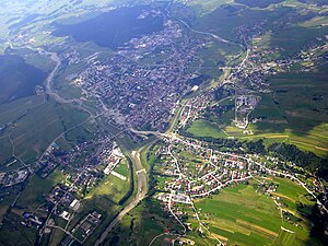
Podhale (Polish pronunciation: [pɔtˈxalɛ] ⓘ; lit. 'below the mountain pastures'), sometimes referred to as the Polish Highlands, is Poland's southernmost region. The Podhale is located in the foothills of the Tatra range of the Carpathian Mountains. It is the most famous[citation needed] region of the Goral Lands which are a network of historical regions inhabited by Gorals.[1]


Local folklore
editThe region is characterized by its unique folklore, which is distinct from other folk cultures in Poland. Its folklore was brought there mainly by settlers from the Lesser Poland region further north and partly by Wallachian (Vlach) settlers in the 14th–17th centuries during their migrations. The name Podhale literally translates as "below the mountains" in English.[2] The various Goral dialects of Polish as well as standard Polish are spoken in the region.
Regional attractions
editAmong the region's attractions are the popular mountain resort of Zakopane and the lake known as Morskie Oko ("The Eye of the Sea"), which local legend claims, is connected to the Adriatic by subterranean passageways. Nowy Targ along the Dunajec River, located in the valley beneath the Gorce Mountains, is the capital of the region. Ludzmierz is home to the area's oldest shrine, Our Lady of Ludźmierz also known as the Hostess of Podhale or in Goral Gaździna Podholańsko.[citation needed]
The people in this region are particularly famous for their oscypek, a cheese made from a mix of cow's and sheep's milk, their music, and their ski slopes. In the winter, it is the number one[citation needed] tourist site in Poland.
See also
editReferences
edit- ^ "Skarby Górali". Fundacja Mapa Pasji (in Polish). Retrieved 2021-12-05.
- ^ "Home -Geography - Podhale and Tatry". Archived from the original on 2016-09-28. Retrieved 2008-03-14.