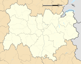
Dionay
Appearance
Dionay | |
|---|---|
Part of Saint-Antoine-l'Abbaye | |
 | |
| Coordinates: 45°12′14″N 5°13′14″E / 45.2039°N 5.2206°E | |
| Country | France |
| Region | Auvergne-Rhône-Alpes |
| Department | Isère |
| Arrondissement | Grenoble |
| Canton | Le Sud Grésivaudan |
| Commune | Saint-Antoine-l'Abbaye |
| Area 1 | 14.01 km2 (5.41 sq mi) |
| Population (2019)[1] | 113 |
| • Density | 8.1/km2 (21/sq mi) |
| Time zone | UTC+01:00 (CET) |
| • Summer (DST) | UTC+02:00 (CEST) |
| Postal code | 38160 |
| Elevation | 392–625 m (1,286–2,051 ft) (avg. 520 m or 1,710 ft) |
| 1 French Land Register data, which excludes lakes, ponds, glaciers > 1 km2 (0.386 sq mi or 247 acres) and river estuaries. | |
You can help expand this article with text translated from the corresponding article in French. (December 2009) Click [show] for important translation instructions.
|
Dionay (French pronunciation: [djɔnɛ]) is a former commune in the Isère department in southeastern France. On 31 December 2015, it was merged into the new commune of Saint-Antoine-l'Abbaye.[2]
Population
[edit]
|
|


Twin towns
[edit]Dionay is twinned with:
 Sermoneta, Italy, since 2007
See also
[edit]References
[edit]Wikimedia Commons has media related to Dionay.


