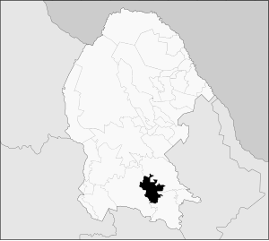
General Cepeda Municipality
Appearance
General Cepeda | |
|---|---|
 Municipality of General Cepeda in Coahuila | |
| Coordinates: 25°22′41″N 101°28′30″W / 25.37806°N 101.47500°W | |
| Country | |
| State | Coahuila |
| Municipal seat | General Cepeda |
| Area | |
| • Total | 3,517 km2 (1,358 sq mi) |
| Population (2005) | |
| • Total | 11,284 |
General Cepeda is one of the 38 municipalities of Coahuila, in north-eastern Mexico. The municipal seat lies at General Cepeda. The municipality covers an area of 3517 km².
As of 2005, the municipality had a total population of 11,284.[1]
References
[edit]- ^ "General Cepeda". Enciclopedia de los Municipios de México. Instituto Nacional para el Federalismo y el Desarrollo Municipal. Archived from the original on May 29, 2007. Retrieved November 8, 2008.


