
Habura
Habura | |
|---|---|
Municipality | |
 | |
 Habura Location of Habura in the Prešov Region  Habura Location of Habura in Slovakia | |
| Coordinates: 49°20′N 21°52′E / 49.333°N 21.867°E | |
| Country | |
| Region | Prešov |
| District | Medzilaborce |
| First mentioned | 1543 |
| Area | |
| • Total | 27.81[2] km2 (10.74[2] sq mi) |
| Elevation | 376[3] m (1,234[3] ft) |
| Population (2021) | |
| • Total | 462[1] |
| Time zone | UTC+1 (CET) |
| • Summer (DST) | UTC+2 (CEST) |
| Postal code | 067 52[3] |
| Area code | +421 57[3] |
| Car plate | ML |
| Website | www |
Habura (Rusyn: Габура; Hungarian: Laborcfő) is a village and municipality in the Medzilaborce District in the Prešov Region of far north-eastern Slovakia.
History
[edit]In historical records the village was first mentioned in 1543. Before the establishment of independent Czechoslovakia in 1918, it was part of Zemplén County within the Kingdom of Hungary.
Geography
[edit]The municipality lies at an altitude of 387 metres, and it covers an area of 27.82 km2. It has a population of about 470 people.
Genealogical resources
[edit]The records for genealogical research are available at the state archive "Statny Archiv in Presov, Slovakia"
- Greek Catholic church records (births/marriages/deaths): 1894-1896 (parish A)
Gallery
[edit]-
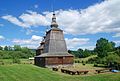
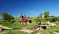 Wooden Church of Saint Nicholas the Miracle-worker in Habura
 -
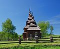
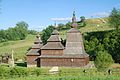 Wooden Church of Saint Nicholas in Habura
 -
 Wooden Church of Saint Nicholas in Habura (seen from the west)
 -
 Wooden Church of Saint Nicholas in Habura (seen from the east)
 -
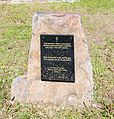 Dedication plaque next to the Church of Saint Nicholas in Habura
 -
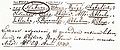 First written record of Habura from 1543
 -
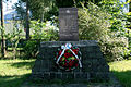
 Memorial to WWII victims from Habura
 -
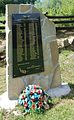
 Memorial to the Slovak National Uprising in Habura
 -
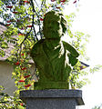 Cpt. Ľudovít Kukorelli memorial bust in Habura
 -
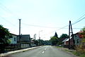 A street in Habura
 -
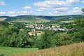 A view of Habura at noon (August 2016)
 -
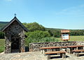 Small chapel, resting area and stopover of a local Slovak National Uprising educational trail
 -
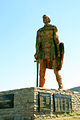 A statue of legendary early medieval prince Laborec on a hill near the village


.jpg)


See also
[edit]References
[edit]- ^ "Počet obyvateľov podľa pohlavia – obce (ročne)". statistics.sk (in Slovak). Statistical Office of the Slovak Republic. 31 March 2022. Retrieved 31 March 2022.
- ^ a b "Hustota obyvateľstva – obce [om7014rr_ukaz: Rozloha (Štvorcový meter)]". statistics.sk (in Slovak). Statistical Office of the Slovak Republic. 31 March 2022. Retrieved 31 March 2022.
- ^ a b c d "Základná charakteristika". statistics.sk (in Slovak). Statistical Office of the Slovak Republic. 17 April 2015. Retrieved 31 March 2022.
- ^ a b "Hustota obyvateľstva – obce". statistics.sk (in Slovak). Statistical Office of the Slovak Republic. 31 March 2022. Retrieved 31 March 2022.
External links
[edit] Media related to Habura at Wikimedia Commons
- Official website

- http://www.statistics.sk/mosmis/eng/run.html Archived 16 November 2007 at the Wayback Machine
- Surnames of living people in Habura
Municipalities of Medzilaborce District | ||
|---|---|---|
This Prešov Region geography article is a stub. You can help Wikipedia by expanding it. |