Hijkersmilde
Appearance
Hijkersmilde | |
|---|---|
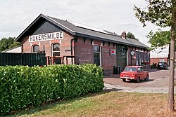
 Former train station of Hijkersmilde with a DAF 46 (2018) | |
 Hijkersmilde in the municipality of Midden-Drenthe. | |
| Coordinates: 52°56′7″N 6°25′52″E / 52.93528°N 6.43111°E | |
| Country | Netherlands |
| Province | Drenthe |
| Municipality | Midden-Drenthe |
| Time zone | UTC+1 (CET) |
| • Summer (DST) | UTC+2 (CEST) |
| Postal code | 9422 |
| Dialing code | 0592 |
Hijkersmilde is a hamlet in the Dutch province of Drenthe. It is a part of the municipality of Midden-Drenthe, and lies about 13 km southwest of Assen.[1] Between 1913 and 1933, it had a train station.[2]
References
[edit]- ^ ANWB Topografische Atlas Nederland, Topografische Dienst and ANWB, 2005.
- ^ "Hijkersmilde". Plaatsengids (in Dutch). Retrieved 12 March 2022.
Wikimedia Commons has media related to Hijkersmilde.


