Nové Město nad Metují: Difference between revisions
population, coordinates |
|||
| Line 17: | Line 17: | ||
| subdivision_type1 = |
| subdivision_type1 = |
||
| subdivision_name1 = |
| subdivision_name1 = |
||
| subdivision_type2 = Region |
| subdivision_type2 = [[Regions of the Czech Republic|Region]] |
||
| subdivision_name2 = Hradec Králové |
| subdivision_name2 = [[Hradec Králové Region|Hradec Králové]] |
||
| subdivision_type3 = District |
| subdivision_type3 = [[Districts of the Czech Republic|District]] |
||
| subdivision_name3 = [[Náchod District|Náchod]] |
| subdivision_name3 = [[Náchod District|Náchod]] |
||
| subdivision_type4 = |
| subdivision_type4 = |
||
| Line 29: | Line 29: | ||
| pushpin_relief = |
| pushpin_relief = |
||
| pushpin_map_caption = Location in Czech Republic |
| pushpin_map_caption = Location in Czech Republic |
||
| coordinates = {{coord|50|20|N|16| |
| coordinates = {{coord|50|20|41|N|16|9|6|E|display=inline,title}} |
||
| coordinates_footnotes = |
| coordinates_footnotes = |
||
<!-- government type, leaders --> |
<!-- government type, leaders --> |
||
| Line 48: | Line 48: | ||
| elevation_ft = |
| elevation_ft = |
||
<!-- population --> |
<!-- population --> |
||
| population_as_of = 2019-01-01<ref>{{cite web |title=Population of municipalities of the Czech republic|url=https://www.czso.cz/documents/10180/91917344/1300721903.pdf/ea01e710-2ae5-49f3-8792-ebb384754346?version=1.0|publisher=Czech Statistical Office|accessdate=2019-04-30}}</ref> |
|||
| population_as_of = 1.1.2012 |
|||
| population_footnotes = |
| population_footnotes = |
||
| population_total = |
| population_total = 9436 |
||
| population_density_km2 = auto |
| population_density_km2 = auto |
||
| population_density_sq_mi= |
| population_density_sq_mi= |
||
| Line 67: | Line 67: | ||
| iso_code = |
| iso_code = |
||
<!-- website, footnotes --> |
<!-- website, footnotes --> |
||
| website = {{URL|http://www.novemestonm.cz |
| website = {{URL|http://www.novemestonm.cz/}} |
||
| footnotes = |
| footnotes = |
||
}} |
}} |
||
'''Nové Město nad Metují''' ({{IPA-cs|ˈnovɛː ˈmɲɛsto ˈnad mɛtujiː}}; {{lang-de|Neustadt an der Mettau}}) is a town on the river [[Metuje]] in the [[Hradec Králové Region]] of the [[Czech Republic]]. Its population |
'''Nové Město nad Metují''' ({{IPA-cs|ˈnovɛː ˈmɲɛsto ˈnad mɛtujiː}}; {{lang-de|Neustadt an der Mettau}}) is a town on the river [[Metuje]] in the [[Hradec Králové Region]] of the [[Czech Republic]]. Its population is around 9,500. |
||
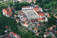
{{stack|[[File:Nové Město nM form air 3.jpg|thumb|Aerial view of the castle and the old town]]}} |
{{stack|[[File:Nové Město nM form air 3.jpg|thumb|Aerial view of the castle and the old town]]}} |
||
| Line 81: | Line 81: | ||
{{Expand section|date=December 2012}} |
{{Expand section|date=December 2012}} |
||
Jan Černčický of Kácov founded the town in 1501. It was destroyed by fire in 1526. Most of the houses on the square were then built after a uniform design in |
Jan Černčický of Kácov founded the town in 1501. It was destroyed by fire in 1526. Most of the houses on the square were then built after a uniform design in 1526–1548. The old town and its fortifications still retain their Renaissance style. [[Wallenstein]] purchased the town in 1623, then it passed to the Trčkas of Lípa and, following the assassination of both in 1634, to [[Walter Leslie (field marshal)|Walter Leslie]]. |
||
Nové Město became the seat of a district after the administrative reform of the [[Austrian Empire]] in mid-19th century. A post office was opened in 1850. Textile mills were founded before the end of the century, followed after 1950 by a factory building construction machinery and a [[watch]]-making factory ([[PRIM (watches)|PRIM]]). The industries and the entire town changed substantially after 1990. |
Nové Město became the seat of a district after the administrative reform of the [[Austrian Empire]] in mid-19th century. A post office was opened in 1850. Textile mills were founded before the end of the century, followed after 1950 by a factory building construction machinery and a [[watch]]-making factory ([[PRIM (watches)|PRIM]]). The industries and the entire town changed substantially after 1990. |
||
| Line 93: | Line 93: | ||
==References== |
==References== |
||
{{reflist}} |
|||
E. Poche (ed.), ''Umělecké památky Čech 2'', Praha: Academia 1978, pp. 492-497 |
* E. Poche (ed.), ''Umělecké památky Čech 2'', Praha: Academia 1978, pp. 492-497 |
||
| ⚫ | |||
| ⚫ | |||
==External links== |
|||
| ⚫ | |||
| ⚫ | |||
| ⚫ | |||
| ⚫ | |||
* [http://www.novemestonm.cz/ Municipal website] {{cs icon}} |
* [http://www.novemestonm.cz/ Municipal website] {{cs icon}} |
||
* [http://www.novemestonm.cz/en/ Municipal website] {{en icon}} |
* [http://www.novemestonm.cz/en/ Municipal website] {{en icon}} |
||
Revision as of 12:41, 27 May 2019
Nové Město nad Metují | |
|---|---|
Town | |
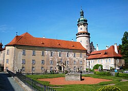
 The castle | |
| Coordinates: 50°20′41″N 16°9′6″E / 50.34472°N 16.15167°E | |
| Country | Czech Republic |
| Region | Hradec Králové |
| District | Náchod |
| Founded | 1501 |
| Government | |
| • Mayor | Petr Hable |
| Area | |
| • Total | 23.12 km2 (8.93 sq mi) |
| Elevation | 332 m (1,089 ft) |
| Population (2019-01-01[1]) | |
| • Total | 9,436 |
| • Density | 410/km2 (1,100/sq mi) |
| Time zone | UTC+1 (CET) |
| • Summer (DST) | UTC+2 (CEST) |
| Postal code | 549 01 |
| Website | www |
Nové Město nad Metují (Czech pronunciation: [ˈnovɛː ˈmɲɛsto ˈnad mɛtujiː]; German: Neustadt an der Mettau) is a town on the river Metuje in the Hradec Králové Region of the Czech Republic. Its population is around 9,500.
Location and geography
Nové Město nad Metují is located in the north of the Czech Republic, a few miles from the Polish border, south of the larger town of Náchod. The old town and the castle sit on a spur in a meander of the river, whence the name "New Town on the Metuje".
History
This section needs expansion. You can help by adding to it. (December 2012) |
Jan Černčický of Kácov founded the town in 1501. It was destroyed by fire in 1526. Most of the houses on the square were then built after a uniform design in 1526–1548. The old town and its fortifications still retain their Renaissance style. Wallenstein purchased the town in 1623, then it passed to the Trčkas of Lípa and, following the assassination of both in 1634, to Walter Leslie.
Nové Město became the seat of a district after the administrative reform of the Austrian Empire in mid-19th century. A post office was opened in 1850. Textile mills were founded before the end of the century, followed after 1950 by a factory building construction machinery and a watch-making factory (PRIM). The industries and the entire town changed substantially after 1990.
Twin towns — Sister cities
Nové Město nad Metují is twinned with:
References
- ^ "Population of municipalities of the Czech republic". Czech Statistical Office. Retrieved 2019-04-30.
- E. Poche (ed.), Umělecké památky Čech 2, Praha: Academia 1978, pp. 492-497
- Ottův slovník naučný nové doby, heslo Nové Město nad Metují. Vol. 7, p. 197
- KČT, Průvodce župou Aloise Jiráska, Náchod 1926
External links
- Municipal website Template:Cs icon
- Municipal website Template:En icon
- Municipal police Template:Cs icon


