Cape Nagasakibana, Kagoshima
Appearance
Cape Nagasakibana, Kagoshima
長崎鼻 長崎鼻岬 | |
|---|---|
 View from Cape Nagasakibana across Kagoshima Bay entrance to the end of the Ōsumi Peninsula | |
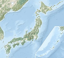
Location of Cape Nagasakibana in Japan | |
| Coordinates: 31°09′19″N 130°35′12″E / 31.15528°N 130.58667°E | |
| Location | Satsuma Peninsula |
| Offshore water bodies | Kagoshima Bay |
| Formed by | Volcanic action |
| Native name | 長崎鼻 |
Nagasakibana (長崎鼻, Nagasakibana), also known as Cape Nagasakibana (長崎鼻岬, Nagasakibana Misaki) or Cape Ryūgū,[1][2] is the most southern headland on the Satsuma Peninsula at the entrance to Kagoshima Bay. The cape has a lighthouse, is the location of a statue of Urashima Tarō, the fisherman in a Japanese fairy tale,[3] and the Ryūgū Shrine.[1]
Geology
[edit]The cape is volcanic in origin and is at the southern border of the Ibusuki Volcanic Field.[4]
Tourism
[edit]There are views from the cape, which is easy to access by car, or train,[1] of both Mount Kaimon and the Satsuma Peninsula and nearby are local botanical and zoological gardens.[3]
References
[edit]- ^ a b c "Ryugu Shrine". Japan RAIL & TRAVEL. KOTSU SHIMBUNSHA. 24 September 2019. Archived from the original on 12 April 2020. Retrieved 12 April 2020.
- ^ "Ryugu Shrine". KYUSHU x TOKYO. Archived from the original on 12 April 2020. Retrieved 12 April 2020.
- ^ a b "Cape Nagasakibana". Retrieved 2022-10-02.
- ^ Nakamura, Masato (1980). "Possibility of New Volcanic Activity at Ibusuki Volcanic Field, Kyushu, Japan". Bulletin of the Volcanological Society of Japan. Second Series. 25 (3): 195–205. doi:10.18940/kazanc.25.3_195. ISSN 2433-0590.

