Cheonho Bridge
Appearance
Cheonho Bridge 천호대교 Cheonho daegyo | |
|---|---|
 | |
| Coordinates | 37°32′34″N 127°06′43″E / 37.542878°N 127.112072°E |
| Crosses | Han River |
| Locale | Seoul, South Korea |
| Other name(s) | Cheonho Grand Bridge |
| Preceded by | Gwangjin Bridge |
| Followed by | Olympic Bridge |
| Characteristics | |
| Total length | 1,150 m (3,770 ft) |
| Width | 25.6 m (84 ft) |
| History | |
| Constructed by | Dong Ah Construction |
| Construction start | August 17, 1974 |
| Construction end | July 5, 1976 |
| Statistics | |
| Daily traffic | 101,633 (2009) |
| Location | |
 | |
| References | |
| [1][2] | |
The Cheonho Bridge[a] crosses the Han River in Seoul, South Korea. It connects Gangdong District and Gwangjin District.[3] The bridge was completed on July 5, 1976.[citation needed] The bridge was built to relieve the heavy traffic on the Gwangjin Bridge, but by 1986 the bridge was experiencing much traffic itself. This was resolved by building the Olympic Bridge in 1988.[1]
Gallery
[edit]-
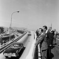
During the opening ceremony for the bridge
Notes
[edit]References
[edit]- ^ a b 천호대교. Naver / Encyclopedia of Korean Culture (in Korean). Naver. Retrieved 18 January 2014.
- ^ 천호대교[ 千戶大橋 ]. Doopedia (in Korean). Naver. Retrieved 18 January 2014.
- ^ 변, 근주, 천호대교 (千戶大橋), Encyclopedia of Korean Culture (in Korean), Academy of Korean Studies, retrieved 2024-07-14
37°32′34.36″N 127°6′43.46″E / 37.5428778°N 127.1120722°E

