Comuna 7
Comuna 7 | |
|---|---|
 | |
| Coordinates: 34°37′49″S 58°28′02″W / 34.63028°S 58.46722°W | |
| Country | |
| Province | |
| Area | |
• Total | 12.4 km2 (4.8 sq mi) |
| Population (2010)[1] | |
• Total | 220,591 |
| Time zone | UTC-3 (ART) |
| • Summer (DST) | UTC-2 |
| Climate | BSh |
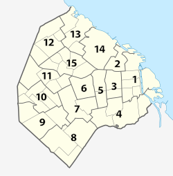
Comuna 7 is one of the 15 communes in which the Autonomous City of Buenos Aires is divided. It is made up of the neighborhoods of Flores and Parque Chacabuco. It is located in the mid-southwest of the city, has an area of 12.4 km²[2] and a total population of 220,591 according to the 2010 census[1] of which 102,481 are men and 118,110 are women, which represent 46.5% and 53.5% of the commune respectively. The 2001 census registered 197,333 inhabitants, which represents an increase of 11.8%.[1]
It is the commune with the third highest proportion of foreigners (18.6%), mostly from neighboring countries; 2 of which 47.8% are of Bolivian origin, followed by those of Peruvian (12.9%) and Paraguayan origin (12.1%). Also noteworthy is the proportion of foreigners of Asian origin (8.6% of the total number of foreigners).[3]
References
[edit]- ^ a b c "Viviendas, población por sexo e índice de masculinidad, según comuna. Año 2010". Archived from the original on 1 September 2012. Retrieved 2 May 2012.
- ^ GCBA. "Población total estimada por sexo, superficie y densidad poblacional según comuna. Ciudad de Buenos Aires. 1° de julio de 2009". Archived from the original (HTML) on 13 September 2011. Retrieved 2 May 2012.
- ^ INDEC. "Censo Nacional de Población, Hogares y Viviendas 2010. Análisis de datos" (PDF). Archived from the original (PDF) on 22 May 2012. Retrieved 10 May 2012.

