Detk
Appearance
Detk | |
|---|---|
Village (község) | |
 Roman Catholic church in Detk | |
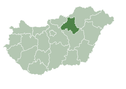
 Location of Heves County in Hungary | |
| Coordinates: 47°44′50.91″N 20°05′57.20″E / 47.7474750°N 20.0992222°E | |
| Country | Hungary |
| Region | Northern Hungary |
| County | Heves County |
| District | Gyöngyös |
| Government | |
| • Mayor | Tamás Stefanovszki (Ind.) |
| Area | |
| • Total | 28.08 km2 (10.84 sq mi) |
| Population (2015) | |
| • Total | 1,165 |
| • Density | 41/km2 (110/sq mi) |
| Time zone | UTC+1 (CET) |
| • Summer (DST) | UTC+2 (CEST) |
| Postal code | 3275 |
| Area code | 37 |
| Website | www.detk.hu |
Detk is a village (population 1,210 (2008 (est.)[1]) in Heves county in Hungary, situated near Gyöngyös on the north-western edge of the Great Hungarian Plain. The landscape to the north and west of the village is scarred by Mátrai Erőmű[2]'s large open-cast lignite mine. The village is most famous for its biscuit company, Detki Keksz Kft.,[3] whose factory is located in the neighbouring village of Halmajugra.

Notes
[edit]- ^ "GeoHive - Hungary population statistics". Archived from the original on 2011-06-10. Retrieved 2010-07-15.
- ^ de:Kraftwerk Mátra
- ^ "Detki Keksz – Együtt lenni jó".


