Freiensteinau
Freiensteinau | |
|---|---|
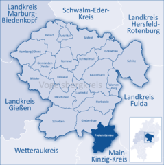
Location of Freiensteinau within Vogelsbergkreis district  | |
| Coordinates: 50°26′N 09°24′E / 50.433°N 9.400°E | |
| Country | Germany |
| State | Hesse |
| Admin. region | Gießen |
| District | Vogelsbergkreis |
| Government | |
| • Mayor (2020–26) | Sascha Spielberger[1] |
| Area | |
| • Total | 65.67 km2 (25.36 sq mi) |
| Elevation | 444 m (1,457 ft) |
| Population (2022-12-31)[2] | |
| • Total | 3,187 |
| • Density | 49/km2 (130/sq mi) |
| Time zone | UTC+01:00 (CET) |
| • Summer (DST) | UTC+02:00 (CEST) |
| Postal codes | 36399 |
| Dialling codes | 06666 |
| Vehicle registration | VB |
| Website | www.freiensteinau.de |
Freiensteinau is a municipality in the Vogelsbergkreis in Hesse, Germany.
Geography
[edit]Location
[edit]Freiensteinau lies on the southern slopes of the Vogelsberg Mountains.
Neighbouring communities
[edit]Freiensteinau borders in the north on the community of Grebenhain, in the northeast on the community of Hosenfeld (Fulda district), in the east on the community of Neuhof (Fulda district), in the south on the town of Steinau an der Straße (Main-Kinzig-Kreis) and in the west on the community of Birstein (Main-Kinzig-Kreis).
Constituent communities
[edit]The community consists of the twelve centres of Freiensteinau (administrative seat), Holzmühl, Fleschenbach, Salz, Ober-Moos, Nieder-Moos, Gunzenau, Reichlos, Weidenau, Reinhards, Hessisch Radmühl and Preußisch Radmühl.
Politics
[edit]Municipal council
[edit]The municipal elections on 26 March 2006 yielded the following results:
| Parties and voter coalitions | Share in % | Seats | |
| CDU | Christian Democratic Union | 25.1 | 5 |
| SPD | Social Democratic Party of Germany | 33.9 | 6 |
| FW | Freie Wähler | 41.0 | 8 |
| total | 100 | 19 | |
Elections in March 2016[3]
- CDU = 2 seats
- SPD = 3 seats
- FW = 8 seats
- UBL = 4 seats
- Bündnis = 2 seats
Mayors
[edit]In July 2014 Sascha Spielberger was elected the new mayor, he started in office in December 2014, and was re-elected in 2020.
Former mayors:
- 1971–1991: Johannes Karl
- 1991–2014: Friedel Kopp
Partnerships
[edit]Culture and sightseeing
[edit]Music
[edit]The organ at the Evangelical Church in Nieder-Moos was built in 1790-1791 by Johann-Markus Oestreich from Oberbimbach near Fulda. Every year, the Nieder-Mooser Sommerkonzerte (Nieder-Moos Summer Concerts) take place around the organ.

Sundry
[edit]A curious fact about the community's political history is that before Hesse's municipal reforms in the 1970s, the 12 constituent communities nowadays within Freiensteinau not only were not united, but even belonged to four different districts: Fulda, Gelnhausen, Lauterbach and Schlüchtern.
References
[edit]- ^ "Ergebnisse der letzten Direktwahl aller hessischen Landkreise und Gemeinden" (XLS) (in German). Hessisches Statistisches Landesamt. 5 September 2022.
- ^ "Bevölkerung in Hessen am 31.12.2022 nach Gemeinden" (XLS) (in German). Hessisches Statistisches Landesamt. June 2023.
- ^ "Ergebnis der Gemeindewahl am 6. März 2016". Hessisches Statistisches Landesamt. April 2016.


