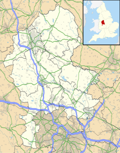
Horton, Staffordshire
| Horton | |
|---|---|
 Horton Hall | |
Location within Staffordshire | |
| Population | 781 (2011 Census) |
| District | |
| Shire county | |
| Region | |
| Country | England |
| Sovereign state | United Kingdom |
| Post town | Leek |
| Postcode district | ST13 |
| Police | Staffordshire |
| Fire | Staffordshire |
| Ambulance | West Midlands |
| UK Parliament | |
Horton is a village and civil parish in the English county of Staffordshire.[1] The population of the civil parish as taken at the 2011 census was 781.[2] It is situated about 3 miles (5 km) W of Leek.
It is first attested as Horten(e) in 1226. The place-name Horton is a common one in England. It derives from Old English horu 'dirt' and tūn 'settlement, farm, estate', presumably meaning 'farm on muddy soil'.[3]
Horton Hall is a Jacobean manor house,[4] built on the site of an earlier house dating back to the 12th Century. It was in the ownership of the Edge family from the 1330s until 1710. It was damaged in the English Civil War, and rebuilt by Timothy Edge from 1653; his initials with the date occur on the lintel of the gateway in the garden.[5]
See also
[edit]References
[edit]- ^ "Secretive 'hidden village' where 'supermodels enjoy lavish champagne parties'". 21 May 2023.
- ^ "Civil Parish population 2011". Retrieved 9 December 2015.
- ^ Victor Watts (ed.), The Cambridge Dictionary of English Place-Names, Based on the Collections of the English Place-Name Society (Cambridge: Cambridge University Press, 2004), s.v. HORTON.
- ^ "Horton Hall, Staffordshire". Daily Telegraph. Archived from the original on 26 January 2013.
- ^ C R J Currie, M W Greenslade (Editors), A P Baggs, M F Cleverdon, D A Johnston, N J Tringham (1996). "Horton". A History of the County of Stafford: Volume 7: Leek and the Moorlands. Institute of Historical Research. Retrieved 11 September 2012.
{{cite web}}:|author=has generic name (help)CS1 maint: multiple names: authors list (link)
External links
[edit]- GENUKI(tm) page
- Map sources for Horton, Staffordshire
53°06′46″N 2°05′17″W / 53.11285°N 2.08810°W

