Kargow
Appearance
Kargow | |
|---|---|
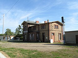
 Train station in Kargow | |
| Coordinates: 53°30′35″N 12°46′47″E / 53.50972°N 12.77972°E | |
| Country | Germany |
| State | Mecklenburg-Vorpommern |
| District | Mecklenburgische Seenplatte |
| Municipal assoc. | Seenlandschaft Waren |
| Government | |
| • Mayor | Manfred Schlüter |
| Area | |
• Total | 69.08 km2 (26.67 sq mi) |
| Elevation | 68 m (223 ft) |
| Population (2023-12-31)[1] | |
• Total | 672 |
| • Density | 9.7/km2 (25/sq mi) |
| Time zone | UTC+01:00 (CET) |
| • Summer (DST) | UTC+02:00 (CEST) |
| Postal codes | 17192 |
| Dialling codes | 03991 |
| Vehicle registration | MÜR |
| Website | www |
Kargow is a municipality in the Mecklenburgische Seenplatte district, in Mecklenburg-Vorpommern, Germany.
References
[edit]- ^ "Bevölkerungsstand der Kreise, Ämter und Gemeinden 2023" (XLS) (in German). Statistisches Amt Mecklenburg-Vorpommern. 2023.


