
Kirvi

Kirvi is a mountain in Suðuroy,[1] near the village Lopra. Kirvi is 236m high and its shape resembles that of a pyramid. The mountain is visible from the villages Lopra. The top of the mountain is called Kirviskollur. The mountain is located in the municipality of Sumba.
Gallery
[edit]-
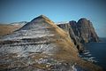
 Kirvi seen from Porkeri
 -
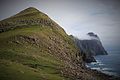 Kirvi, right the cliff Beinisvørð
 -
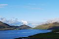
 Kirvi is in the center of this photo
 -


References
[edit]- ^ US.fo Archived 2011-07-20 at the Wayback Machine
External links
[edit]- Visitsuduroy.fo Archived 2010-03-16 at the Wayback Machine, The Tourist Information Center
- Sumba.fo, The municipality of Sumba (Faroe Islands).
61°26′19″N 6°46′57″W / 61.4387°N 6.7826°W
This Faroe Islands location article is a stub. You can help Wikipedia by expanding it. |