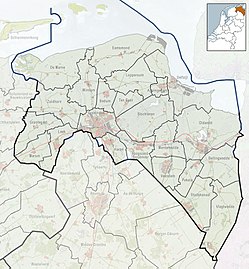
Krewerd
Krewerd | |
|---|---|
 Maria Church in Krewerd | |
| Coordinates: 53°21′14″N 6°50′56″E / 53.35389°N 6.84889°E | |
| Country | Netherlands |
| Province | Groningen |
| Municipality | Eemsdelta |
| Area | |
| • Total | 0.07 km2 (0.03 sq mi) |
| Elevation | 0.3 m (1.0 ft) |
| Population (2021)[1] | |
| • Total | 75 |
| • Density | 1,100/km2 (2,800/sq mi) |
| Postal code | 9904[3] |
| Dialing code | 0596[4] |
Krewerd (Dutch pronunciation: [ˈkreːʋərt]; Gronings: Kraiwerd [ˈkrɑiʋət]) is a village with a population of around 75[1] in the municipality of Eemsdelta in the province of Groningen in the Netherlands. The medieval village church houses a gothic organ from 1531, which is still largely in its original state.
History
[edit]The village was first mentioned in 1280 as Crewerth, and means "crow (Corvus corone) terp".[5] Krewerd is a terp (artificial living hill) village with radial structure which dates from between 800 and 1100.[6][7] In the late middle ages, a canal was dug to the Damsterdiep.[6]
The monastery Nijenklooster used to be located near Krewerd. It was a Premonstratensian monastery which was an outpost of Bloemhof, and the official name was "Campus Rosarum". It was demolished in 1574.[8] The Dutch Reformed church was built around 1280, and the tower was added 1400. A western entrance was built in the tower in 1782.[6]
Krewerd was home to 85 people in 1840.[7]
Geography
[edit]Krewerd is located in the municipality of the Delfzijl in the north of the province of the Groningen in the northeast of the Netherlands.
Krewerd lies directly northwest of Delfzijl and about 24 km northeast of the city of Groningen.
Gallery
[edit]-
Former location of the monastery Nijenklooster
-
Bonnemaheerd
-
Former pub Maathuis (1900-1905)
References
[edit]- ^ a b c "Kerncijfers wijken en buurten 2021". Central Bureau of Statistics. Retrieved 7 April 2022.
- ^ "Postcodetool for 9904PA". Actueel Hoogtebestand Nederland (in Dutch). Het Waterschapshuis. Retrieved 7 April 2022.
- ^ (in Dutch) Zoekresultaten, Postcode.nl. Retrieved on 12 April 2015.
- ^ (in Dutch) Netnummer 0596 Krewerd, Netnummer.info. Retrieved on 12 April 2015.
- ^ "Krewerd - (geografische naam)". Etymologiebank (in Dutch). Retrieved 7 April 2022.
- ^ a b c Ronald Stenvert & Redmer Alma (1998). "Krewerd" (in Dutch). Zwolle: Waanders. ISBN 90 400 9258 3. Retrieved 7 April 2022.
- ^ a b "Krewerd". Plaatsengids (in Dutch). Retrieved 7 April 2022.
- ^ "Over Kreweld". Nieuwsblad van het Noorden (in Dutch). 10 October 1936. Retrieved 7 April 2022.
External links
[edit] Media related to Krewerd at Wikimedia Commons


