Lea Newbold
Appearance
| Lea Newbold | |
|---|---|
 Lea Hall Farm | |
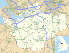
Location within Cheshire | |
| Population | 8 (2001) |
| OS grid reference | SJ432589 |
| Civil parish | |
| Unitary authority | |
| Ceremonial county | |
| Region | |
| Country | England |
| Sovereign state | United Kingdom |
| Post town | MALPAS |
| Postcode district | CH3 |
| Dialling code | 01244 |
| Police | Cheshire |
| Fire | Cheshire |
| Ambulance | North West |
| UK Parliament | |
Lea Newbold is a former civil parish, now in the parish of Aldford and Saighton, in the borough of Cheshire West and Chester and ceremonial county of Cheshire in England. In 2001 it has a population of 8.[1] Lea-Newbold was formerly a township in the parish of St Oswald,[2] in 1866 Cotton Edmunds became a separate civil parish,[3] on 1 April 2015 the parish was abolished to form Aldford and Saighton.[4]
See also
[edit]References
[edit]- ^ Office for National Statistics : Census 2001 : Parish Headcounts : Chester Retrieved 2009-12-19
- ^ "History of Lea Newbold, in Chester and Cheshire". A Vision of Britain through Time. Retrieved 23 September 2024.
- ^ "Relationships and changes Lea Newbold CP/Tn through time". A Vision of Britain through Time. Retrieved 23 September 2024.
- ^ "Aldford & Saighton". GENUKI. Retrieved 23 March 2018.
External links
[edit]![]() Media related to Lea Newbold at Wikimedia Commons
Media related to Lea Newbold at Wikimedia Commons

