Leni
Appearance
You can help expand this article with text translated from the corresponding article in Italian. (January 2022) Click [show] for important translation instructions.
|
Leni
Lenós (Greek) | |
|---|---|
 | |
| Coordinates: 38°33′N 14°50′E / 38.550°N 14.833°E | |
| Country | Italy |
| Region | Sicily |
| Metropolitan city | Messina (ME) |
| Frazioni | Rinella, Valdichiesa |
| Government | |
| • Mayor | Giacomo Montecristo |
| Area | |
| • Total | 8.79 km2 (3.39 sq mi) |
| Elevation | 202 m (663 ft) |
| Population (31 October 2023)[2] | |
| • Total | 679 |
| • Density | 77/km2 (200/sq mi) |
| Demonym | Lenesi |
| Time zone | UTC+1 (CET) |
| • Summer (DST) | UTC+2 (CEST) |
| Postal code | 98050 |
| Dialing code | 090 |
| Website | Official website |
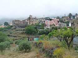
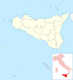
Leni is a comune (municipality) and one of the main towns on Salina, one of the Aeolian Islands, in the Metropolitan City of Messina, Sicily, southern Italy. It is located about 140 kilometres (87 mi) northeast of Palermo and about 70 kilometres (43 mi) northwest of Messina.
Leni lies on the slope of the hill on the south of the island, 200 metres (660 ft) above the sea, between the volcanoes of Monte Fossa and Monte dei Porri.
Leni borders the municipalities of Malfa and Santa Marina Salina.

People
[edit]- Nino Randazzo (born 1932)
Twin towns
[edit] Ischia, since 2013
References
[edit]- ^ "Superficie di Comuni Province e Regioni italiane al 9 ottobre 2011". Italian National Institute of Statistics. Retrieved 16 March 2019.
- ^ All demographics and other statistics: Italian statistical institute Istat.
Wikimedia Commons has media related to Leni.
External links
[edit]


