Municipality of Kungota
Appearance
Municipality of Kungota
Občina Kungota | |
|---|---|
 | |
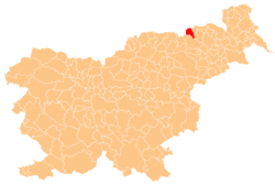
 Location of the Municipality of Kungota in Slovenia | |
| Coordinates: 46°25′N 15°47′E / 46.417°N 15.783°E | |
| Country | |
| Government | |
| • Mayor | Tamara Šnofl |
| Area | |
• Total | 49.0 km2 (18.9 sq mi) |
| Population (2002)[1] | |
• Total | 4,317 |
| • Density | 88/km2 (230/sq mi) |
| Time zone | UTC+01 (CET) |
| • Summer (DST) | UTC+02 (CEST) |
| Website | www |
The Municipality of Kungota (pronounced [ˈkuːŋɡɔta]; Slovene: Občina Kungota) is a municipality in the western part of the Slovene Hills (Slovene: Slovenske gorice) in northeastern Slovenia. Its seat is the village of Zgornja Kungota.[2] It borders Austria.
Settlements
[edit]In addition to the municipal seat of Zgornja Kungota, the municipality also includes the following settlements:
References
[edit]External links
[edit] Media related to Municipality of Kungota at Wikimedia Commons
- Municipality of Kungota on Geopedia


