
Mystery Mountain (Idaho)
| Mystery Mountain | |
|---|---|
.jpg) Northeast aspect, centered | |
| Highest point | |
| Elevation | 9,830 ft (2,996 m)[1] |
| Prominence | 626 ft (191 m)[1] |
| Parent peak | McGowan Peak (9,878 ft)[1] |
| Isolation | 0.80 mi (1.29 km)[1] |
| Coordinates | 44°12′22″N 115°04′05″W / 44.206°N 115.068°W[2] |
| Geography | |
 Mystery Mountain Location in Idaho  Mystery Mountain Mystery Mountain (the United States) | |
| Country | United States |
| State | Idaho |
| County | Custer |
| Protected area | Sawtooth Wilderness |
| Parent range | Sawtooth Range Rocky Mountains |
| Topo map | USGS Stanley Lake |
| Geology | |
| Age of rock | Eocene[3] |
| Mountain type | Fault block |
| Type of rock | Granodiorite, Granite[3] |
| Climbing | |
| Easiest route | class 2[1] |
Mystery Mountain is a 9,830-foot-elevation (2,996 m) summit in Custer County, Idaho, United States.
Description
[edit]Mystery Mountain is part of the Sawtooth Range which is a subrange of the Rocky Mountains.[4] It is situated seven miles (11 km) west of Stanley, Idaho, in the Sawtooth Wilderness on land managed by Sawtooth National Forest.[2] The mountain can be seen from Highway 21 and from Stanley Lake. Precipitation runoff from the mountain drains to the Salmon River via Crooked Creek and Valley Creek. Topographic relief is significant as the summit rises over 3,000 feet (914 meters) above Crooked Creek in one mile (1.6 km). This mountain's toponym has not been officially adopted by the United States Board on Geographic Names.
Climate
[edit]Based on the Köppen climate classification, Mystery Mountain is located in an alpine subarctic climate zone with long, cold, snowy winters, and cool to warm summers.[5] Winter temperatures can drop below 0 °F with wind chill factors below −10 °F. Climbers can expect afternoon rain and lightning from summer thunderstorms.
See also
[edit]Gallery
[edit]-
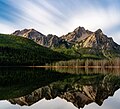 Mystery Mountain (left) and McGowan Peak (right) illuminated by moonlight and reflected in Stanley Lake
 -
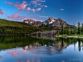 Mystery Mountain (left) and McGowan Peak (right) seen from Stanley Lake


References
[edit]- ^ a b c d e "Mystery Mountain - 9,830' ID". listsofjohn.com. Retrieved 2024-07-22.
- ^ a b "Mystery Mountain, Idaho". Peakbagger.com. Retrieved 2024-07-22.
- ^ a b Geologic Map of Idaho, Reed S. Lewis, Idaho Geological Survey, 2012.
- ^ Exploring the Sawtooths, Matt Leidecker, Idaho River Publications, 2012, ISBN 9780615654485.
- ^ Peel, M. C.; Finlayson, B. L.; McMahon, T. A. (2007). "Updated world map of the Köppen−Geiger climate classification". Hydrol. Earth Syst. Sci. 11: 1633–1644. ISSN 1027-5606.
Places adjacent to Mystery Mountain (Idaho) | ||||||||||||||||
|---|---|---|---|---|---|---|---|---|---|---|---|---|---|---|---|---|
| ||||||||||||||||