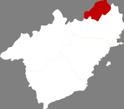
Nanpiao District
Appearance
Nanpiao
南票区 | |
|---|---|
 Nanpiao in Huludao | |
 Huludao in Liaoning | |
| Country | People's Republic of China |
| Province | Liaoning |
| Prefecture-level city | Huludao |
| Time zone | UTC+8 (China Standard) |
Nanpiao District (simplified Chinese: 南票区; traditional Chinese: 南票區; pinyin: Nánpiào Qū) is a district under the administration of the city of Huludao, Liaoning province, People's Republic of China. It is a mostly rural district containing no large urban centres, and comprises an area of 512 square kilometres (198 sq mi),[1] in the northernmost part of Huludao City.
The administrative center of the district is Nanpiao town, which is linked to central Huludao by bus and train services.
Administrative divisions
[edit]There are seven subdistricts, two towns, and two townships within the district.[2]
Subdistricts:
- Jiulong Subdistrict, Jiulong Subdistrict (九龙街道), Qiupigou Subdistrict (邱皮沟街道), Xiaolinghe Subdistrict (小凌河街道), Zhaojiatun Subdistrict (赵家屯街道), Weizigou Subdistrict (苇子沟街道), Shaguotun Subdistrict (沙锅屯街道), Sanjiazi Subdistrict (三家子街道)
Towns:
- Nuanchitang (暖池塘镇), Gangyaoling (缸窑岭镇)
Townships:
- Shaguotun Township (沙锅屯乡), Huangtukan Township (黄土坎乡)
References
[edit]- ^ "Huludao Administrative Districts". Huludao Municipal Government. Archived from the original on 2009-10-05. Retrieved 2010-01-08.
- ^ 葫芦岛市-行政区划网
External links
[edit]41°06′25″N 120°45′00″E / 41.10694°N 120.75000°E
