Ninfield
| Ninfield | |
|---|---|
 Church of St Mary The Virgin, Ninfield | |
Location within East Sussex | |
| Area | 10.6 km2 (4.1 sq mi) [1] |
| Population | 1,562 (2011)[2] |
| • Density | 372/sq mi (144/km2) |
| OS grid reference | TQ706124 |
| • London | 49 miles (79 km) NNW |
| District | |
| Shire county | |
| Region | |
| Country | England |
| Sovereign state | United Kingdom |
| Post town | BATTLE |
| Postcode district | TN33 |
| Dialling code | 01424 |
| Police | Sussex |
| Fire | East Sussex |
| Ambulance | South East Coast |
| UK Parliament | |
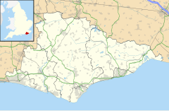
Ninfield is a village and civil parish in the Wealden District of East Sussex, England. The village is quite linear and centred 4 miles (6.4 km) north of Bexhill-on-Sea where two roads cross: the A269 from Bexhill to Battle and the A271 to Hailsham. The parish covers 2,500 acres (1,010 ha); approximately the northern half of which is in the High Weald AONB.
To the west of the village is Standard Hill, said to be the place that William the Conqueror placed his flag (2 lions of Normandy standard) before the Battle of Hastings.[3] As with many other Wealden villages, it was involved in the iron industry: that fact is commemorated by the presence in the village of a set of iron stocks. Smuggling was also rife in the eighteenth century.
The village name is said to come from the fact that it was originally composed of nine and three quarter fields.[citation needed] A legal record, of 1452, mentioning a Sussex village as "Nempnefeld", may refer to Ninfield. [4]
Civil parish and civic events
[edit]The parish council consists of nine councillors.[5] They put on several events, including a gala with professional cabaret, each year to raise money for nominated charities such as Alzheimers and Sussex Ambulance.
Amenities
[edit]Ninfield has a primary school,[6] a shop and two pubs- The Kings Arms and the Blacksmiths Inn. It has two churches, its medieval parish church dedicated to St Mary the Virgin; and the Methodist church.
Cultural references and former residents
[edit]Ninfield was once featured in an episode of the classic comedy The Goon Show entitled The Nadger Plague and first broadcast by the BBC in October 1956. In the episode, set in the 16th century, the residents of Ninfield were left terrified when two carriers of the titular plague, which caused the seats of peoples' trousers to "burn out", arrived in the village. The episode was written by Spike Milligan, a sometime resident of East Sussex.
James T.A. Osborne (d. 1979), painter, artistic print maker, etcher and engraver long settled in Ninfield.
Local government
[edit]Ninfield is currently drawn, for the purposes of the fair apportionment of District Councillors as part of electoral ward: Ninfield and Hooe with Wartling. The population of this ward at the 2011 Census was 2,543.[7]
Built-up component
[edit]The central, contiguous area of 558 homes on 65 hectares has been identified as a small Built-up Area, in the statistical government bodies definition (ONS and GSS) and had in 2011 a total of 1,307 residents.[8] Population density of this area was 20.1 persons per hectare.
Notable people
[edit]eSports participant and sim-racer Jimmy Broadbent is from Ninfield.
References
[edit]- ^ "East Sussex in Figures". East Sussex County Council. Retrieved 26 April 2008.
- ^ "Civil Parish population 2011". Retrieved 11 October 2015.
- ^ Historical notes, Vision of Britain website
- ^ Plea Rolls of the Court of Common Pleas; National Archives; image seen at: 4th entry down; Sussex in the margin; http://aalt.law.uh.edu/AALT3/H6/CP40no764/aCP40no764fronts/IMG_0391.htm
- ^ "The Parish Council representatives". Archived from the original on 29 October 2007. Retrieved 12 May 2008.
- ^ Ninfield CE Primary School website
- ^ "Ninfield and Hooe with Wartling ward population 2011". Retrieved 11 October 2015.
- ^ "Custom report - Nomis - Official Labour Market Statistics".
External links
[edit]![]() Media related to Ninfield at Wikimedia Commons
Media related to Ninfield at Wikimedia Commons

