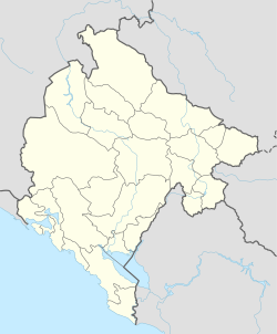
Njeguši
Appearance
Njeguši
Његуши | |
|---|---|
 View over Njeguši with the Bay of Kotor in the background, 2012 | |
| Coordinates: 42°25′59″N 18°49′42″E / 42.4331°N 18.8283°E | |
| Country | |
| Municipality | |
| Population (2011) | |
• Total | 35 |
| Time zone | UTC+1 (CET) |
| • Summer (DST) | UTC+2 (CEST) |
Njeguši (Montenegrin Cyrillic: Његуши) is a village in the Cetinje Municipality of southern Montenegro, located on the slopes of Mount Lovćen, within the Lovćen national park. It is part of the historical territory of the Njeguši tribe.
Demographics
[edit]According to the 2003 census, the village had 17 inhabitants, of whom 15 declared as Montenegrins, 1 as Serb, and 1 Unknown. According to 2011 census, there were 35 inhabitants, 33 of whom were Montenegrins, one did not want to reveal ethnicity and one was a Russian.[1][2]
References
[edit]- ^ Zavod za Statistiku Crne Gore. 2011. "Popis na nivou nasejla." http://www.monstat.org/cg/page.php?id=536&pageid=322
- ^ Становништво, национална или етничка припадност, подаци по насељима. Подгорица: Републички завод за статистику (2004). ISBN 978-86-84433-00-0.

