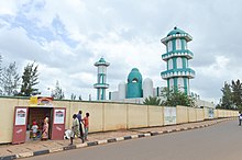
Nyamirambo
Appearance
This article has multiple issues. Please help improve it or discuss these issues on the talk page. (Learn how and when to remove these messages)
|
Nyamirambo Sector | |
|---|---|
 Shown within Kigali Province and Rwanda | |
| Country | Rwanda |
| Province | Kigali Province |
| District | Nyarugenge District |
| Sector | Nyamirambo Sector |
Nyamirambo is a sector (umurenge) in Nyarugenge District, Kigali Province, Rwanda.
Location
[edit]It is located in the southwest part of the city of Kigali. The coordinates of Nyamirambo Sector are:1°59'37.0"S, 30°02'39.0"E (Latitude:-1.993611; Longitude:30.044167).[1]
Overview
[edit]
It is a mixed residential and commercial sector, with many mosques.[2] AB Bank Rwanda, a microfinance bank maintains a branch in the sector.[3]
Sectors of Nyarugenge District
[edit]Nyarugenge district is divided into 10 sectors (imirenge): Gitega, Kanyinya, Kigali, Kimisagara, Mageragere, Muhima, Nyakabanda, Nyamirambo, Nyarugenge, and Rwezamenyo.

References
[edit]- ^ "Location of Nyamirambo Sector At Google Maps". Google Maps. Retrieved 3 August 2014.
- ^ Inga (1 February 2011). "Living In Nyamirambo". LivingInKigali.Com. Retrieved 3 August 2014.
- ^ Gasore, Ben (13 June 2014). "AB Bank Rwanda Loan Book Hits RWF:1 Billion". The New Times (Rwanda). Archived from the original on 10 August 2014. Retrieved 3 August 2014.
