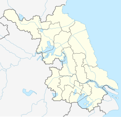
Runzhou, Zhenjiang
Appearance
Runzhou
润州区 | |
|---|---|
 Runzhou District in July 2017 | |
| Coordinates: 32°11′30″N 119°24′45″E / 32.1916°N 119.4125°E[1] | |
| Country | People's Republic of China |
| Province | Jiangsu |
| Prefecture-level city | Zhenjiang |
| Area | |
• Total | 132.68 km2 (51.23 sq mi) |
| Population (2020 census) | |
• Total | 299,956 |
| • Density | 2,300/km2 (5,900/sq mi) |
| Time zone | UTC+8 (China Standard) |
| Postal code | 212004 |
Runzhou District (simplified Chinese: 润州区; traditional Chinese: 潤州區; pinyin: Rùnzhōu Qū) is one of three districts of Zhenjiang, Jiangsu Province, China.
To the east of Runzhou lies the Grand Canal and Jingkou District with Zhenjiang New District to the southeast. The district has an area of 132.68 km2. By the end of 2020, the total population was 299,956 people.[2]
Administrative divisions
[edit]At present, Runzhou District has 7 subdistricts.[3]
- 7 subdistricts
|
References
[edit]- ^ "Runzhou" (Map). Google Maps. Retrieved 2014-07-02.
- ^ "Rùnzhōu Qū (District, China) - Population Statistics, Charts, Map and Location". www.citypopulation.de. Retrieved 2024-11-20.
- ^ "镇江市-行政区划网 www.xzqh.org" (in Chinese). XZQH. Retrieved 2012-05-24.
External links
[edit]

