
Rush, Colorado
Rush, Colorado | |
|---|---|
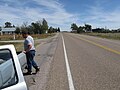
 Looking west down Highway 94, Pikes Peak is in the distance | |
 Rush Location in El Paso County and the state of Colorado  Rush Rush (the United States) | |
| Coordinates: 38°50′24″N 104°05′32″W / 38.84000°N 104.09222°W | |
| Country | |
| State | |
| County | El Paso County[1] |
| Elevation | 6,017 ft (1,834 m) |
| Time zone | UTC-7 (MST) |
| • Summer (DST) | UTC-6 (MDT) |
| ZIP code | 80833[2] |
| Area code | 719 |
| GNIS feature ID | 193570[1] |
Rush is an unincorporated community and a U.S. Post Office located in El Paso County, Colorado, United States.
Named for Christopher Rush, a homesteader from Missouri who settled there in 1907.[3]
Education
[edit]Miami-Yoder School District 60JT serves Rush.
Geography
[edit]-
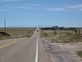
 Rush Colorado, looking east
 -
 Pikes Peak from Rush, Colorado


Rush is located east of Yoder along State Highway 94 about 2 miles (3 km) west of the El Paso - Lincoln County line.
See also
[edit]References
[edit]- ^ a b c U.S. Geological Survey Geographic Names Information System: Rush, Colorado
- ^ "ZIP Code Lookup" (JavaScript/HTML). United States Postal Service. January 2, 2007. Retrieved January 2, 2007.
- ^ Bright, William (2004). Colorado Place Names. Johnson Books. ISBN 9781555663339.
Municipalities and communities of El Paso County, Colorado, United States | ||
|---|---|---|
| Cities |  | |
| Towns | ||
| CDPs | ||
| Unincorporated communities | ||
| Ghost towns | ||
| Footnotes | ‡This populated place also has portions in an adjacent county or counties | |