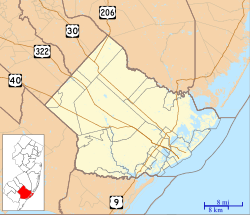
Sweetwater, New Jersey
Appearance
Sweetwater, New Jersey | |
|---|---|
Location in Atlantic County Location in New Jersey | |
| Coordinates: 39°37′16″N 74°38′17″W / 39.62111°N 74.63806°W | |
| Country | |
| State | |
| County | Atlantic |
| Township | Mullica |
| Area | |
| • Total | 3.74 sq mi (9.69 km2) |
| • Land | 3.56 sq mi (9.23 km2) |
| • Water | 0.18 sq mi (0.46 km2) |
| Elevation | 7 ft (2 m) |
| Population | |
| • Total | 805 |
| • Density | 225.81/sq mi (87.18/km2) |
| ZIP Code | 08037 |
| FIPS code | 34-71880[3] |
| GNIS feature ID | 0881058[4] |
| Census | Pop. | Note | %± |
|---|---|---|---|
| 2020 | 805 | — | |
| U.S. Decennial Census[5] | |||
Sweetwater is an unincorporated community and census-designated place (CDP)[6] located within Mullica Township in Atlantic County, in the U.S. state of New Jersey.[7] The community is situated on the Mullica River about 20 miles (32 km) from Atlantic City.
References
[edit]- ^ "ArcGIS REST Services Directory". United States Census Bureau. Retrieved October 11, 2022.
- ^ "Census Population API". United States Census Bureau. Retrieved October 11, 2022.
- ^ Geographic Codes Lookup for New Jersey, Missouri Census Data Center. Accessed June 9, 2023.
- ^ "Sweetwater". Geographic Names Information System. United States Geological Survey, United States Department of the Interior. Retrieved September 20, 2012.
- ^ "Census of Population and Housing". Census.gov. Retrieved June 4, 2016.
- ^ State of New Jersey Census Designated Places - BVP20 - Data as of January 1, 2020, United States Census Bureau. Accessed December 1, 2022.
- ^ Locality Search, State of New Jersey. Accessed June 9, 2016.


