Swinden
Appearance
| Swinden | |
|---|---|
 Swinden Hall, built in 1657 | |
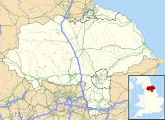
Location within North Yorkshire | |
| Population | 20 |
| OS grid reference | SD861543 |
| Civil parish | |
| Unitary authority | |
| Ceremonial county | |
| Region | |
| Country | England |
| Sovereign state | United Kingdom |
| Post town | Skipton |
| Postcode district | BD23 |
| Police | North Yorkshire |
| Fire | North Yorkshire |
| Ambulance | Yorkshire |
| UK Parliament | |
Swinden is a village in the civil parish of Hellifield, in North Yorkshire, England. It is near Halton West and Nappa and about 7 miles (11 km) north of Barnoldswick. The population was estimated at 20 in 2010.[1]
Swinden was historically a township in the ancient parish of Gisburn in the West Riding of Yorkshire.[2] It became a separate civil parish in 1866.[3] It was transferred to the new county of North Yorkshire in 1974. The civil parish was abolished on 1 April 2014 and amalgamated with the parish of Hellifield.[4][5] From 1974 to 2023 it was in Craven district.
References
[edit]- ^ "Population Estimates". North Yorkshire County Council. 2010. Archived from the original on 13 January 2012. Retrieved 27 June 2013.
- ^ Genuki. Parish of Gisburn
- ^ Vision of Britain website
- ^ "The Craven District Council (Reorganisation of Community Governance) Order 2011". Retrieved 27 August 2014.
- ^ "North Yorkshire Registration District". UKBMD. Retrieved 25 November 2023.
External links
[edit]![]() Media related to Swinden at Wikimedia Commons
Media related to Swinden at Wikimedia Commons

