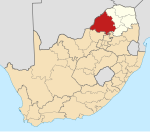
Tshamahansi
Appearance
Tshamahansi | |
|---|---|
| Coordinates: 24°04′41″S 28°58′44″E / 24.078°S 28.979°E | |
| Country | South Africa |
| Province | Limpopo |
| District | Waterberg |
| Municipality | Mogalakwena |
| Area | |
• Total | 6.21 km2 (2.40 sq mi) |
| Population (2011)[1] | |
• Total | 14,274 |
| • Density | 2,300/km2 (6,000/sq mi) |
| Racial makeup (2011) | |
| • Black African | 99.8% |
| • Indian/Asian | 0.1% |
| First languages (2011) | |
| • Tsonga | 75.9% |
| • Northern Sotho | 15.9% |
| • S. Ndebele | 4.3% |
| • Other | 3.9% |
| Time zone | UTC+2 (SAST) |
| PO box | 0659 |
Tshamahansi is a large, populated semi-urban rural township in the Mogalakwena Local Municipality of the Capricorn District Municipality of the Limpopo province in South Africa. It's located about 15,1 km north of the town of Mokopane on the N11 road.[2]
References
[edit]- ^ a b c d "Main Place Tshamahansi". Census 2011.
- ^ SABC (16 September 2012). "SABC News - Tshamahansi". Sabc.co.za. Retrieved 11 April 2017.


