Tzurit
Appearance
Tzurit | |
|---|---|
 Tzurit in 1984 | |
| Coordinates: 32°54′7″N 35°15′2″E / 32.90194°N 35.25056°E | |
| Country | Israel |
| District | Northern |
| Council | Misgav |
| Affiliation | Mishkei Herut Beitar |
| Founded | April 1981 |
| Population (2022)[1] | 949 |
| Website | www.zurit.co.il |
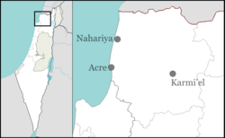
Tzurit (Hebrew: צוּרִית) is a community settlement in northern Israel. Located in the western Galilee region, west of Karmiel, it falls under the jurisdiction of Misgav Regional Council. In 2022 it had a population of 949.[1]
History
[edit]The gar'in that founded Tzurit was formed in central Israel in 1979, with the village established by thirteen families in April 1981.[2] The village is named the wildflower Sedum (Tzurit in Hebrew) that is found nearby.[3]
Notable residents
[edit]References
[edit]- ^ a b "Regional Statistics". Israel Central Bureau of Statistics. Retrieved 21 March 2024.
- ^ Villages of Israel
- ^ "Zurit homepage". Archived from the original on 2018-10-15.
- ^ Lev-Ari, Shiri (August 2, 2006). "The Pen - Mightier Than the Sword?". Haaretz. Retrieved May 27, 2019.
External links
[edit]- Village website (in Hebrew)

