Upper Gravenhurst
Appearance
| Upper Gravenhurst | |
|---|---|
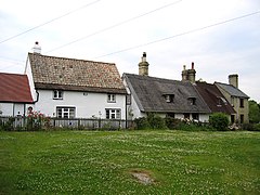
 Cottages in Upper Gravenhurst, viewed from the churchyard next to the church | |
Location within Bedfordshire | |
| OS grid reference | TL113360 |
| Civil parish | |
| Unitary authority | |
| Ceremonial county | |
| Region | |
| Country | England |
| Sovereign state | United Kingdom |
| Post town | BEDFORD |
| Postcode district | MK45 |
| Dialling code | 01462 |
| Police | Bedfordshire |
| Fire | Bedfordshire and Luton |
| Ambulance | East of England |
| UK Parliament | |
Upper Gravenhurst is a village and former civil parish, now in the parish of Gravenhurst, in the Central Bedfordshire district of the ceremonial county of Bedfordshire, England. In 1881 the parish had a population of 354.[1] On 24 March 1888 the parish was abolished and merged with Lower Gravenhurst to form "Gravenhurst".[2]
The Church of St Giles has been established in the village since the 12th Century. The first school in the village was built in 1870, today known as Gravenhurst Academy.[3]
References
[edit]- ^ "Population statistics Upper Gravenhurst AP/Ch/CP through time". A Vision of Britain through Time. Retrieved 31 January 2023.
- ^ "Ampthill Registration District". UKBMD. Retrieved 31 January 2023.
- ^ "'Gravenhurst history timeline'". Galaxy.bedfordshire.gov.uk. 15 March 2007. Archived from the original on 22 February 2012. Retrieved 6 August 2012.
External links
[edit]

