Grana (AT)
Aspetto
| Grana comune tagliàne | |||
|---|---|---|---|
 | |||
| |||
| State | |||
| Reggione | |||
| Provinge | Asti | ||
| Coordinate | 44°59′57″N 8°18′02″E | ||
| Altitudine | 289 m s.l.m. | ||
| Superficie | 6,03 km² | ||
| Crestiàne | 610 (31-05-2007 (fonte Istat)) | ||
| Denzetà | 101 cr./km² | ||
| Comune 'nzeccate | Calliano, Casorzo, Castagnole Monferrato, Grazzano Badoglio, Moncalvo, Montemagno, Penango | ||
| CAP | 14031 | ||
| Prefisse | 0141 | ||
| Codece ISTAT | 005056 | ||
| Cod. catastale | E134 | ||
| Nome javetande | granesi | ||
| Patrone | Santa Maria Assunta | ||
| Sciurne festive | 15 agosto | ||
| Site istituzionale | |||
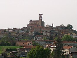
Grana éte 'nu comune tagliáne de 615 crestiáne.
Categorije:
- Pagine con argomenti di formatnum non numerici
- Stub
- P625 uguale sus Uicchidate
- Prefisso telefonico locale uguale a Wikidata
- Codice ISTAT uguale a Wikidata
- P18 lette da Uicchidate
- P41 assende sus Uicchidate
- P94 differende sus Uicchidate
- P281 uguale sus Uicchidate
- P806 uguale sus Uicchidate
- P856 differende sus Uicchidate
- P2044 uguale sus Uicchidate
- P2046 differende sus Uicchidate
- Comune d'u Piemonte
- Comune d'a provinge de Asti
- Pàggene cu le mappe

