Allumiere
Allumiere | |
|---|---|
| Comune di Allumiere | |
| Coordinates: 42°9′N 11°54′E / 42.150°N 11.900°E | |
| Kintra | Italy |
| Region | Lazio |
| Province | Province o Roum (RM) |
| Govrenment | |
| • Mayor | Augusto Battilocchio |
| Area | |
| • Total | 92.2 km2 (35.6 sq mi) |
| Elevation | 522 m (1,713 ft) |
| Population (2008[1]) | |
| • Total | 4,247 |
| • Density | 46/km2 (120/sq mi) |
| Demonym(s) | Allumieraschi |
| Time zone | UTC+1 (CET) |
| • Summer (DST) | UTC+2 (CEST) |
| Postal code | 00051 |
| Diallin code | 0766 |
| Patron saunt | St. Mary o Graces (Madonna delle Grazie) |
| Saunt day | September 8 |
| Website | Offeecial wabsteid |
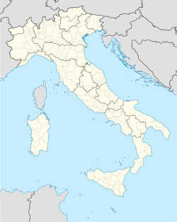
Allumiere is a comune (municipality) in the Province o Roum in the Italian region Latium, locatit aboot 60 km northwast o Roum.
Allumiere is tradeetionally dividit intae the contrade o Burò, Ghetto, La Bianca, Nona, Polveriera, an Sant'Antonio.
History
[eedit | eedit soorce]Awtho evidence o human dounsets in the local aurie date back tae the Neolithic age, the oreegins o the modern toun o Allumiere are relatively recent. Allumiere wis foondit in the late 15t century tae hoose the wirkers an the admeenistrators o the important mines o alunite o the nearbi Monti della Tolfa range. The exploitation lastit till 1941. The mines in question wur foond shortly efter the faw o the Eastren Roman Empire (1453). Before that date, the State o the Kirk uised tae buy alunite frae thare, but follaein the Turkis conquest, they haed tae fynd alternatives.
Twin touns
[eedit | eedit soorce] Puçol, Spain
 Deutschkreutz, Austrick
 Eglfing, Germany
References
[eedit | eedit soorce]Freemit airtins
[eedit | eedit soorce]- www.allumiere.org/ Archived 2021-04-25 at the Wayback Machine
- Aircheological steids

